야르칸드현: 두 판 사이의 차이
내용 삭제됨 내용 추가됨
잔글 봇: 틀 이름 및 스타일 정리 |
|||
| 13번째 줄: | 13번째 줄: | ||
[[파일:Street scene in Yarkand in the 1870s.jpg|섬네일|360px|야르칸드 1870년대]] |
[[파일:Street scene in Yarkand in the 1870s.jpg|섬네일|360px|야르칸드 1870년대]] |
||
야르칸드 오아시스는 적어도 [[기원전 2세기]]에 중국에 알려져 있었다. 그러나 야르칸드에 대한 구체적인 기술은 [[후한서]]에 기록되어 남았다. |
야르칸드 오아시스는 적어도 [[기원전 2세기]]에 중국에 알려져 있었다. 그러나 야르칸드에 대한 구체적인 기술은 [[후한서]]에 기록되어 남았다. |
||
== 인구 == |
|||
{{Historical populations|align=left |
|||
|type=China |
|||
|percentages = pagr |
|||
|2000|620329 |
|||
|2010|762385 |
|||
|footnote = <ref name="xzqhyarkant"/> |
|||
|}}{{-}} |
|||
== 기후 == |
|||
{{Weather box |
|||
|metric first=y |
|||
|single line=y |
|||
|location = Yarkhant (1981−2010 normals) |
|||
|Jan high C = 0.8 |
|||
|Feb high C = 6.5 |
|||
|Mar high C = 15.2 |
|||
|Apr high C = 23.1 |
|||
|May high C = 27.6 |
|||
|Jun high C = 31.2 |
|||
|Jul high C = 32.6 |
|||
|Aug high C = 31.0 |
|||
|Sep high C = 26.8 |
|||
|Oct high C = 20.4 |
|||
|Nov high C = 11.5 |
|||
|Dec high C = 2.4 |
|||
|Jan mean C = −5.2 |
|||
|Feb mean C = 0.2 |
|||
|Mar mean C = 8.5 |
|||
|Apr mean C = 15.9 |
|||
|May mean C = 20.2 |
|||
|Jun mean C = 23.8 |
|||
|Jul mean C = 25.3 |
|||
|Aug mean C = 23.8 |
|||
|Sep mean C = 19.1 |
|||
|Oct mean C = 11.9 |
|||
|Nov mean C = 3.8 |
|||
|Dec mean C = −3.2 |
|||
|Jan low C = −10.3 |
|||
|Feb low C = −5.3 |
|||
|Mar low C = 2.3 |
|||
|Apr low C = 9.0 |
|||
|May low C = 13.4 |
|||
|Jun low C = 16.9 |
|||
|Jul low C = 18.6 |
|||
|Aug low C = 17.3 |
|||
|Sep low C = 12.0 |
|||
|Oct low C = 4.7 |
|||
|Nov low C = −2.1 |
|||
|Dec low C = −7.5 |
|||
|Jan precipitation mm = 1.9 |
|||
|Feb precipitation mm = 1.7 |
|||
|Mar precipitation mm = 4.8 |
|||
|Apr precipitation mm = 4.9 |
|||
|May precipitation mm = 8.2 |
|||
|Jun precipitation mm = 9.9 |
|||
|Jul precipitation mm =10.2 |
|||
|Aug precipitation mm = 9.1 |
|||
|Sep precipitation mm = 5.9 |
|||
|Oct precipitation mm = 1.7 |
|||
|Nov precipitation mm = 1.8 |
|||
|Dec precipitation mm = 1.0 |
|||
|Jan humidity = 65 |
|||
|Feb humidity = 55 |
|||
|Mar humidity = 45 |
|||
|Apr humidity = 39 |
|||
|May humidity = 43 |
|||
|Jun humidity = 43 |
|||
|Jul humidity = 49 |
|||
|Aug humidity = 56 |
|||
|Sep humidity = 60 |
|||
|Oct humidity = 59 |
|||
|Nov humidity = 60 |
|||
|Dec humidity = 69 |
|||
|unit precipitation days = 0.1 mm |
|||
|Jan precipitation days = 1.7 |
|||
|Feb precipitation days = 1.6 |
|||
|Mar precipitation days = 1.2 |
|||
|Apr precipitation days = 1.1 |
|||
|May precipitation days = 2.4 |
|||
|Jun precipitation days = 3.2 |
|||
|Jul precipitation days = 3.5 |
|||
|Aug precipitation days = 3.2 |
|||
|Sep precipitation days = 1.5 |
|||
|Oct precipitation days = 0.9 |
|||
|Nov precipitation days = 0.3 |
|||
|Dec precipitation days = 1.5 |
|||
|Jan sun = 181.6 |Jan percentsun = 60 |
|||
|Feb sun = 182.8 |Feb percentsun = 61 |
|||
|Mar sun = 205.0 |Mar percentsun = 56 |
|||
|Apr sun = 231.4 |Apr percentsun = 59 |
|||
|May sun = 262.9 |May percentsun = 60 |
|||
|Jun sun = 303.6 |Jun percentsun = 69 |
|||
|Jul sun = 296.6 |Jul percentsun = 66 |
|||
|Aug sun = 268.2 |Aug percentsun = 64 |
|||
|Sep sun = 257.7 |Sep percentsun = 69 |
|||
|Oct sun = 261.4 |Oct percentsun = 75 |
|||
|Nov sun = 222.8 |Nov percentsun = 74 |
|||
|Dec sun = 186.3 |Dec percentsun = 63 |
|||
|source 1 = China Meteorological Administration (precipitation days and sunshine 1971–2000)<ref name="cma graphical">{{cite web|url=http://data.cma.cn/data/weatherBk.html |script-title=zh:中国气象数据网 - WeatherBk Data |publisher=[[China Meteorological Administration]] |language = zh-cn |access-date=2020-04-15}}</ref><ref name="CMA old"> |
|||
{{cite web|url=http://old-cdc.cma.gov.cn/shuju/search1.jsp?dsid=SURF_CLI_CHN_MUL_MMON_19712000_CES&tpcat=SURF&type=table&pageid=3 |script-title=zh:中国地面国际交换站气候标准值月值数据集(1971-2000年)|publisher=[[China Meteorological Administration]] |access-date=2010-05-25 |url-status=dead |archive-url=https://web.archive.org/web/20130921055035/http://old-cdc.cma.gov.cn/shuju/search1.jsp?dsid=SURF_CLI_CHN_MUL_MMON_19712000_CES&tpcat=SURF&type=table&pageid=3 |archive-date=2013-09-21 |
|||
}}</ref> |
|||
}} |
|||
== 각주 == |
|||
{{각주}} |
|||
{{신장 위구르 자치구}} |
{{신장 위구르 자치구}} |
||
2021년 2월 13일 (토) 13:47 판


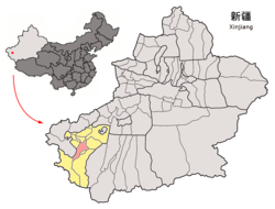
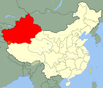
야르칸드현(위구르어: يەكەن ناھىيىسى, Yerkent) 혹은 사처현(중국어: 莎车县, 병음: Shāchē Xiàn)은 신장 위구르 자치구 카슈가르 지구의 현급 행정구역이다. 넓이는 9037km2이고, 인구는 2007년 기준으로 710,000명이다.
해발고도는 약 1,189m이며 무상일수는 177일이다. 야르칸드는 타림 분지 내의 타클라마칸 사막의 남쪽 주변의 신장 위구르 자치구의 현이었다. 그곳은 카슈가르 지구의 11개 현 중의 하나이다. 야르칸드는 실크로드에 있었던 고대 불교국가 사차의 위치이다.
비옥한 오아시스는 쿤룬 산맥에서 북쪽으로 흐르는 야르칸드 강에 의해 물이 공급된다. 오아시스는 약 3,210km²의 면적에 물을 공급한다.
주민과 경제
오늘날 야르칸드는 위구르족이 우세하다. 관개된 오아시스의 경지에서 면화, 밀, 옥수수, 과일(특히 석류, 배, 살구)와 호두가 생산된다. 야크와 양이 고지에서 방목된다. 광물 자원으로 석유, 천연 가스, 금, 구리, 납, 보크사이트, 화강암, 석탄이 포함된다.
역사

야르칸드 오아시스는 적어도 기원전 2세기에 중국에 알려져 있었다. 그러나 야르칸드에 대한 구체적인 기술은 후한서에 기록되어 남았다.
인구
| 연도 | 인구 | ±% p.a. |
|---|---|---|
| 2000 | 620,329 | — |
| 2010 | 762,385 | +2.08% |
| [1] | ||
기후
| Yarkhant (1981−2010 normals)의 기후 | |||||||||||||
|---|---|---|---|---|---|---|---|---|---|---|---|---|---|
| 월 | 1월 | 2월 | 3월 | 4월 | 5월 | 6월 | 7월 | 8월 | 9월 | 10월 | 11월 | 12월 | 연간 |
| 평균 일 최고 기온 °C (°F) | 0.8 (33.4) |
6.5 (43.7) |
15.2 (59.4) |
23.1 (73.6) |
27.6 (81.7) |
31.2 (88.2) |
32.6 (90.7) |
31.0 (87.8) |
26.8 (80.2) |
20.4 (68.7) |
11.5 (52.7) |
2.4 (36.3) |
19.1 (66.4) |
| 일 평균 기온 °C (°F) | −5.2 (22.6) |
0.2 (32.4) |
8.5 (47.3) |
15.9 (60.6) |
20.2 (68.4) |
23.8 (74.8) |
25.3 (77.5) |
23.8 (74.8) |
19.1 (66.4) |
11.9 (53.4) |
3.8 (38.8) |
−3.2 (26.2) |
12.0 (53.6) |
| 평균 일 최저 기온 °C (°F) | −10.3 (13.5) |
−5.3 (22.5) |
2.3 (36.1) |
9.0 (48.2) |
13.4 (56.1) |
16.9 (62.4) |
18.6 (65.5) |
17.3 (63.1) |
12.0 (53.6) |
4.7 (40.5) |
−2.1 (28.2) |
−7.5 (18.5) |
5.8 (42.4) |
| 평균 강수량 mm (인치) | 1.9 (0.07) |
1.7 (0.07) |
4.8 (0.19) |
4.9 (0.19) |
8.2 (0.32) |
9.9 (0.39) |
10.2 (0.40) |
9.1 (0.36) |
5.9 (0.23) |
1.7 (0.07) |
1.8 (0.07) |
1.0 (0.04) |
61.1 (2.4) |
| 평균 강수일수 (≥ 0.1 mm) | 1.7 | 1.6 | 1.2 | 1.1 | 2.4 | 3.2 | 3.5 | 3.2 | 1.5 | 0.9 | 0.3 | 1.5 | 22.1 |
| 평균 상대 습도 (%) | 65 | 55 | 45 | 39 | 43 | 43 | 49 | 56 | 60 | 59 | 60 | 69 | 54 |
| 평균 월간 일조시간 | 181.6 | 182.8 | 205.0 | 231.4 | 262.9 | 303.6 | 296.6 | 268.2 | 257.7 | 261.4 | 222.8 | 186.3 | 2,860.3 |
| 가능 일조율 | 60 | 61 | 56 | 59 | 60 | 69 | 66 | 64 | 69 | 75 | 74 | 63 | 65 |
| 출처: China Meteorological Administration (precipitation days and sunshine 1971–2000)[2][3] | |||||||||||||
각주
- ↑ 인용 오류:
<ref>태그가 잘못되었습니다;xzqhyarkant라는 이름을 가진 주석에 텍스트가 없습니다 - ↑ 中国气象数据网 - WeatherBk Data (중국어 (중국)). China Meteorological Administration. 2020년 4월 15일에 확인함.
- ↑ 中国地面国际交换站气候标准值月值数据集(1971-2000年). China Meteorological Administration. 2013년 9월 21일에 원본 문서에서 보존된 문서. 2010년 5월 25일에 확인함.


