
사용자:Aspere/미국의 영토 변화
이 문서는 다른 언어판 위키백과의 문서(en:Territorial evolution of the United States)를 번역 중이며, 한국어로 좀 더 다듬어져야 합니다. |


미국은 1776년 7월 4일 북아메리카의 13개 식민지가 대영 제국으로부터 독립선언을 함으로서 만들어졌다. 이틀 전 이루어진 제2차 대륙회의에서 통과된 리 결의안에서 각 식민지는 자유롭고 독립된 주라고 결의하였으며, 1781년 3월 1일 13개 주 모두가 연합규약을 비준하며 합중국 체계가 갖춰졌다. 영국은 1783년 파리 조약을 통해 미국의 독립을 인정하였으며, 이를 통해 미국 독립 전쟁이 종전을 맞이했다. 식민지의 서쪽 경계는 1763년 선언의 경계선에서 미시시피강까지 확대되어, 면적이 거의 두 배 가량 증가하였다. 새로 얻은 땅은 준주를 거쳐 주로 만들어졌으며, 간혹 주에서 연방정부에 토지를 할양하기도 하였다.
미국 역사 최초의 대규모 영토 확장은 1803년 루이지애나 매입이었으며, 이 때 면적이 약 두 배 가량 증가하였다. 동남쪽의 스페인령 플로리다와의 국경은 분쟁 지역이었으나, 1821년 스페인이 플로리다와 오리건 컨트리를 미국에 할양하며 종결되었다. 비록 이 시기에는 영국과 오리건을 공유하기는 하였으나. 미국은 오리건을 통해 태평양에 진입할 수 있었다.[2] 1845년 텍사스 공화국 합병으로 인해 멕시코-미국 전쟁이 발발하였으며, 미국은 승전국으로서 멕시코 영토의 북쪽 절반을 획득하였다. 이 시기 획득한 영토는 캘리포니아주 등 빠르게 주로 편입되었다.[3]
미국 국내 산업 개발이 서쪽으로 이동함에 따라, 새로 획득한 영토에서 노예 제도가 허가되어야 하는지에 대한 논란이 지속되었으며, 미주리 타협이나 피의 캔자스 등 여러 사건이 발생하였다. 이 논쟁은 1861년 초 미국 남부가 합중국을 탈퇴한 후 아메리카 연합국의 성립을 선포하며 극에 달하였으며, 이어진 남북 전쟁을 통해 1865년 연합국은 패배하여 미국 의회의 결정에 따라 남부 주는 결국 합중국으로 재편입되었다. 19세기 내내 이루어진 서부로의 확장은 명백한 운명이 주요한 동기로 작용하였다.
1856년 구아노 제도법을 통해 미국이 북아메리카 바깥으로 확장하기 시작하였으며, 미국이 카리브해와 태평양에 있는 경제적 가치를 가지는 작은 무인도 여럿의 영유권을 주장하기 시작하였는데,[4] 이 중 대다수는 다른 국가와의 영유권 경쟁으로 인해 결국 영유권 주장을 철회하였다. 태평양 확장은 1893년 하와이 왕국 정부가 전복된 5년 후인 1898년 하와이가 합병되며 끝을 맞았다. 1867년 러시아로부터 알래스카를 구매함으로서 북아메리카에서의 마지막 대규모 영토 획득이 이루어졌다. 쿠바 독립 전쟁에 대한 지지와 USS 메인의 침몰이 배경이 되어 1898년 미국-스페인 전쟁이 발발하였으며, 여기서 미국은 푸에르토리코, 괌, 필리핀을 획득하였으며, 쿠바를 몇 년 간 점령하였다. 1900년 제2차 사모아 내전을 통해서는 아메리칸사모아를 획득하였으며,[5] 1917년에는 덴마크로부터 미국령 버진아일랜드를 구매하였다.[6] 푸에르토리코와 괌은 영토로 계속 남아 있으나, 필리핀은 제2차 세계 대전에서 주요 전장으로 발전한 후 1946년 독립하였다.
제2차 세계 대전 이후 유엔은 태평양의 여러 섬을 미국에 신탁통치로 넘겼으며,[7] 이 중 북마리아나 제도는 미국 영토가 되었으나 마셜 제도, 미크로네시아, 팔라우는 독립하였다. 미국 역사상 마지막으로 이루어진 국제적 영토 변화는 1904년 획득한 파나마 운하 지대로, 파나마 운하를 관리하기 위해 미국이 획득한 운하 주변의 영토였다. 이 지역은 1979년 최초 반환을 거쳐 1999년 최종적으로 파나마에 완전히 반환되었다.
주는 대체로 만들어진 후 경계를 그대로 유지하는 경향이 있다. 주 3개(켄터키, 메인, 웨스트버지니아)만이 다른 주에 속한 땅에서 바로 형성되었으며, 다른 주는 모두 연방 직할지나 새로 획득한 영토에서 만들어졌다. 주 4개(루이지애나, 미주리, 네바다, 펜실베이니아)는 성립 이후 연방 영토를 획득하여 상당 수준 확장되었다. 1912년 애리조나주가 미국 본토에서 생겨난 마지막 48번째 주가 되었으며, 1959년 마지막 50번째로 하와이주가 생겨났다.
지도 범례
[편집]- 지도 속 색 범례
- 미국의 주 (국내 지도), 영유권 분쟁이 없는 미국 영토 (분쟁 지도)
- 미국의 준주 또는 영토 (국내 지도)
- 미국이 영유권을 주장한 분쟁 지역
- 어떠한 사건에 의해 변화한 영역
1776~1784 (독립 전쟁)
[편집]| 날짜 | 사건 | 지도 |
|---|---|---|
| 1776년 7월 4일 | 그레이트브리튼 왕국의 북아메리카 식민지인 13개 식민지가 아메리카 합중국으로서 독립을 선언하였다.[a] 일부 식민지는 이 날짜 전에도 스스로 독립을 선언하기도 하였다.[8]
당시 수도는 명문화하지 않았으나, 대륙회의는 필라델피아에서 개최되었다.[25][26] 주 다수는 서로 간의 경계가 명확하게 정의되지 않았었으며, 토지 조사도 이루어지지 않아 실제로 분쟁이 일어나기 전까지는 지도에 표시하지도 않았었다. 특히 노스캐롤라이나의 경계는 조사가 거의 이루어지지 않았는데, 사우스캐롤라이나와의 경계는 여러 번에 나눠 조사하여 결과가 서로 일치하지 않는 문제가 있었으며,[27][28] 버지니아와의 경계 조사는 바다에서 시작해 내륙으로 절반 정도만 들어가고 종료되었다. 동북쪽 주인 코네티컷, 메사추세츠만, 뉴욕은 모두 경계 서쪽의 영유권을 주장하였는데 주장 범위가 서로 겹쳤으며, 버지니아의 서쪽 영유권 주장은 방대하게 펼쳐져 있었다. 세 주 중 코네티컷만 진지하게 영유권을 주장하였으며, 버지니아만 실질적으로 군(카운티)을 설치하여 제한적으로나마 행정을 펼쳤다. 영국은 새로 생긴 아메리카 합중국 전역의 영유권을 주장하였으며, 이 중 동북쪽 해안에 있는 작은 섬인 마키아스실섬과 노스록은 현재까지 영유권 분쟁 중에 있다.[29] |
 분쟁:
|
| 1776년 9월 20일 | 델라웨어의 뉴캐슬, 켄트, 서섹스군이 1776년 델라웨어 헌법을 채택하며 이름을 델라웨어주로 바꾸었다.[30] | 
|
| 1776년 9월 28일 | 펜실베이니아주가 1776년 펜실베이니아 헌법을 채택하며 이름을 펜실베이니아 코먼웰스로 바꾸었다.[31] | (지도 상의 변화 없음) |
| 1776년 12월 20일 | 필라델피아로 진격 중이던 영국군을 피하기 위해 대륙회의가 발티모어에서 개최되었다.[25][26] | 
|
| 1777년 1월 15일 | 뉴욕주 동북부의 뉴햄프셔 불하지가 뉴코네티컷이라는 이름으로 독립하였다.[32][33][34] | 분쟁:
|
| 1777년 3월 4일 | 영국군의 위협이 사라짐에 따라 대륙회의가 필라델피아로 복귀하였다.[25][26] | 
|
| 1777년 6월 4일 | 뉴코테니컷의 이름이 버몬트로 바뀌었다.[34][32] | 분쟁:
|
| 1777년 9월 27일 | 미국군의 브랜디와인 전투 패배로 인해 대륙회의가 필라델피아를 탈출해 랭커스터로 이동하였다.[25][26] | 
|
| 1777년 9월 30일 | 대륙회의가 지속적으로 필라델피아에서 멀어지며 요크에 정착하였다.[25][26] | 
|
| 1778년 6월 11일 | 버몬트가 '동부 연합'이라고 불리던 뉴햄프셔 마을 일부가 버몬트에 합류하였다고 주장하였다. 이 지역은 뉴햄프셔 정부가 해안 지방에만 집중한다는 불만을 이유로 3월 12일 버몬트 공화국에 참여하겠다는 서명을 제출한 바 있었다. 버몬트는 끝까지 이 지역에서 완전한 주권을 행사하지 못하였다.[32][35][36][37][b] | 분쟁:
|
| 1778년 10월 21일 | 버몬트가 대륙회의의 압력으로 인해 동부 연합 합병을 철회하였다. 1779년 2월 12일에 입법부에서는 동부 연합 합병이 처음부터 무효였던 것으로 간주하기로 결정하였다.[35][36][37] | 분쟁:
|
| 1779년 7월 2일 | 영국군의 철수에 따라 대륙회의가 필라델피아로 복귀하였다.[25][26] | 
|
| 1779년 8월 31일 | 버지니아가 서남쪽 웨스트어구스타 지구를 영유권을 주장하던 펜실베이니아에 넘겼다.[20][38] | 
|
| 1780년 3월 | 노스캐롤라이나와 버지니아가 내륙 지방의 경계선을 조사하였다. 버지니아 측의 조사는 테네시강에 도달했으나 노스캐롤라이나 측은 컴벌랜드고개까지밖에 가지 못했으며, 두 조사팀의 거리는 약 2마일 떨어져 있었기 때문에 두 주 모두가 영유권을 주장하는 얇은 영역이 생겼다. 경계 자체는 북위 36°30′ 선을 따라갈 예정이었으나, 조사 시의 문제로 인해 경로가 북쪽으로 틀어져, 테네시강에 도착했을 때는 약 10마일 정도의 오차가 생겨 있었다.[39][24] | 
|
| 1780년 10월 25일 | 매사추세츠만주가 매사추세츠 헌법을 채택하며 이름을 매사추세츠 코먼웰스로 바꾸었다. | 
|
| 1781년 3월 1일 | 연합규약이 발효되었다.[40] | (지도 상의 차이 없음) |
| 1781년 4월 4일 | 버몬트가 다시 뉴햄프셔 부근의 여러 동부 연합 마을을 합병하였다고 주장하였다. 1778년 최초 시도에 비해 버몬트에 합류하고자 한 마을의 수는 증가하였으나, 마찬가지로 정확한 경계선은 불분명하며, 버몬트는 끝까지 이 지역에서 완전한 주권을 행사하지 못하였다.[32][41][36][37][c] | 분쟁:
|
| 1781년 6월 16일 | 버몬트가 동부 확장의 균형을 맞추기 위해 '서부 연합'이라고 부르는 뉴욕의 여러 마을을 합병하였다고 주장하였다. 버몬트는 끝까지 이 지역에서 완전한 주권을 행사하지 못하였다.[32][36][42][43] 합병 주장이 이루어진 정확한 날짜는 불분명하며, 6월 16일, 6월 26일, 7월 18일이라는 주장이 각각 존재한다.[d] | 분쟁:
|
| 1782년 2월 22일 | 버몬트가 뉴햄프셔의 동부 연합과 뉴욕의 서부 연합 합병 시도를 철회하였다.[32][37][43][44] | 분쟁:
|
| 1782년 10월 29일 | 1780년 2월 29일 뉴욕이 연방정부에 할양한 서부 영유권 주장을 연방정부가 수용하였다. 뉴욕은 새 서부 경계선을 온타리오호 서쪽 끝에서 남쪽으로 그은 선으로 정하였다. 당초 뉴욕은 이리호, 휴런호, 미시간호로 둘러싸여 일리노이강, 미시시피강, 테네시강까지 이어지는 영역 전체를 주장했으며, 북쪽 경계는 펜실베이니아와 닿는 애팔래치아산맥이었다.[45] 이 영유권 주장이 어디서 유래하였는지는 명확하지 않다. 주장을 포기하였다는 자료는 다수 존재하나, 처음에 어떻게 생겨났는지에 대한 언급은 거의 나타나지 않는다. 이에 대해 당초 해당 지역을 점령했던 이로쿼이 연맹이 할양한 것이라는 주장이 있다.[46] 하지만 뉴욕은 이 지역의 영유권을 진지하게 주장하지는 않았다. 할양된 부분 중에는 펜실베이니아 북부의 작은 땅이 포함되어 있는데, 이 지역을 이리 트라이앵글이라고 부른다.[47][18] | 
|
| 1782년 12월 30일 | 연합회의가 코네티컷이 영유권을 주장한 펜실베이니아 북부의 땅이 펜실베이니아의 일부라고 선포함으로서 양키-펜실베이니아 전쟁을 끝내려고 시도하였다.[48][20] 이 영유권 주장은 코네티컷의 북쪽 및 남쪽 경계를 뉴저지와 뉴욕은 건너뛰고 서쪽으로 확장한 것에서 나온 것으로, 분쟁은 이후에도 지속되었으나 코네티컷의 공식적 영유권 주장은 이를 통해 막을 내렸다. | 
|
| 1783년 6월 30일 | 1783년 펜실베이니아 반란과 이에 대한 펜실베이니아 정부의 대응을 이유로 연합회의가 필라델피아를 떠나 프린스턴으로 이동하였다.[25] | 
|
| 1783년 11월 26일 | 연합회의가 아나폴리스에서 재결성되었다.[25] | 
|
| 1784년 3월 1일 | 버지니아가 오하이오강 서북부의 영유권 주장을 연방정부에 할양하였다.[49][24] 코네티컷은 버지니아의 할양 부분과 겹치는 지역의 영유권 주장을 지속하였다. | 
|
| 1784년 5월 12일 | 그레이트브리튼 왕국이 파리 조약을 통해 아메리카 합중국의 독립을 인정하였으며, 영유권 주장을 포기하였다.[50][51][e] 비록 1781년 10월 19일 요크타운 전투 이후 군사 행동은 실질적으로 이루어지지 않고 있었으나, 파리 조약을 통해 미국 독립 전쟁이 공식적으로 종전을 맞이하였다.
파리 조약에서는 애매하게 쓰인 조문과 지리 조사의 부족으로 인해 불분명한 점이 몇 존재하였다.
파리에서 맺어진 평화 조약 중에는 프랑스 및 스페인과의 조약도 포함되어 있었으며, 이 때 영국이 플로리다를 스페인에 할양하였다. 영국은 서플로리다 통치 기간 중 서플로리다의 경계를 북쪽으로 옮겼으며, 스페인에게 할양할 때 이를 반영하여 서플로리다 전체를 할양하는 것으로 해석하였다. 하지만 영국과 미국 간의 조약에서는 서플로리다의 확대된 부분, 정확히는 북위 31°선 북쪽을 조지아에 할양하였으며, 이는 경계 조정 이전의 서플로리다만을 스페인에 할양하겠다는 것으로 해석할 수 있다. 스페인 총독 일부는 미시시피강에 위치한 요새를 점령해 테네시강 남쪽의 영토 전체에 대한 영유권을 주장하였는데, 이 영유권 주장이 얼마나 강했는지는 불분명하며, 다른 서플로리다 경계 주장과 겹쳤기 때문에 지도에는 표시하지 않았다.[52] |
 분쟁: 
|


1784~1803 (영토 정비)
[편집]| 날짜 | 사건 | 지도 |
|---|---|---|
| 1784년 8월 23일 | 노스캐롤라이나 중부(현재의 테네시 동부)에서 주 정부의 행정에 불만을 갖고 프랭클랜드주로서 독립을 선포하였다.[f][53] 프랭클린주 정부는 해당 지역에서 어느 정도 행정력을 행사하였고, 주의 지위를 얻기 위한 청원을 벌여 필요치인 9개 주 중 7개 주의 동의를 얻어냈으나, 존속 기간은 몇 년밖에 되지 않았다.[54][55] | 비공식 변경:
|
| 1784년 11월 1일 | 연합회의가 잠시 동안 트렌턴으로 이동하였다.[25] | 
|
| 1785년 1월 11일 | 연합회의가 뉴욕으로 이동하여 5년 동안 머물렀다.[25] | 
|
| 1785년 4월 19일 | 매사추세츠가 연방정부에 할양한 극서 지역 영유권 주장을 연방정부가 수용하였다. 매사추세츠가 이 지역의 영유권을 진지하게 주장한 적은 없었다.[g][45][14] | 서류 상의 변경:
|
| 1785년 6월 | 프랭클랜드주가 이름을 프랭클린주로 바꾸었다. 이는 벤저민 프랭클린의 지지를 얻기 위해서였으나, 벤저민 프랭클린은 지지 선언을 거부하였다.[54] | 비공식 변경:
|
| 1786년 9월 13일 | 코네티컷이 웨스턴 리저브를 제외하고 연방정부에 할양한 서부 지역 영유권 주장을 연방정부가 수용하였다. 코네티컷이 실제로 이 지역에서 얼마나 행정력을 행사하였는지는 알려지지 않았다.[h][9][56] | 서류 상의 변경:
|
| 1786년 12월 16일 | 매사추세츠가 뉴욕 서부의 영유권 주장을 할양하였다. 매사추세츠의 영유권 주장은 "주권이 아니라 땅"에 대한 것이었다는 점에서, 실제로 행정을 펼친 적 자체가 있는지조차 밝혀지지 않았다.[i][45][14] 이 지역은 이후 펠프스 및 고램 매매의 대상이 되었다. | 서류 상의 변경:
|
| 1787년 7월 13일 | 버지니아가 할양하였던 오하이오강 서북쪽 영토가 조례를 통해 북서부 준주노스우가 되었다.[57][58] | 
|
| 1787년 8월 9일 | 사우스캐롤라이나가 연방정부에 서부 영유권을 할양하였는데,[23][59] 실제로 사우스캐롤라이나는 이 지역의 영유권을 주장한 적이 없으며 부정확한 토지 조사로 인해 생겨난 오류였다. 영유권 주장 지역은 "노스캐롤라이나와의 경계부터 투갈루강의 발원지 사이에 놓인 땅"이었는데, 실제로 투갈루강의 발원지는 노스캐롤라이나 안에 있었으나 당시에는 이 사실이 알려지지 않았었다. 이 지역은 현실적으로 이미 조지아에 속해 있었으며, 1802년 공식적으로 할양되었다.[60] | 서류 상의 변경:
|
| 1787년 12월 7일 | 델라웨어가 첫 번째로 미국의 헌법을 비준하였다.[61] | (지도 상의 변화 없음) |
| 1787년 12월 12일 | 펜실베이니아가 두 번째로 헌법을 비준하였다.[62] | |
| 1787년 12월 18일 | 뉴저지가 세 번째로 헌법을 비준하였다.[63] | |
| 1788년 1월 2일 | 조지아가 네 번째로 헌법을 비준하였다..[64] | |
| 1788년 1월 9일 | 코네티컷이 다섯 번째로 헌법을 비준하였다. | |
| 1788년 2월 6일 | 매사추세츠가 여섯 번째로 헌법을 비준하였다. | |
| 1788년 4월 28일 | 메릴랜드가 일곱 번째로 헌법을 비준하였다.[67] | |
| 1788년 5월 23일 | 사우스캐롤라이나가 여덞 번째로 헌법을 비준하였다.[68] | |
| 1788년 6월 21일 | 뉴햄프셔가 아홉 번째로 헌법을 비준하였다.[69] 9개 주가 비준하였기 때문에 이 시점부터 헌법 제7조에 따라 헌법이 공식 행정 문서로서의 자격을 취득하였다. | |
| 1788년 6월 25일 | 버지니아가 열 번째로 헌법을 비준하였다.[70] | |
| 1788년 7월 26일 | 뉴욕이 열한 번째로 헌법을 비준하였다.[71] | |
| 1789년 2월 | 프랭클린주의 주지사 존 시비어가 노스캐롤라이나에게 충성을 맹세하였으며, 프랭클린주의 독립이 실질적으로 끝났다.[54][72] | 비공식 변경:
|
| 1789년 8월 7일 | 헌법에 따라 북서부 준주가 재법인화되었다.[73] | (지도 상의 변화 없음) |
| 1789년 11월 21일 | 노스캐롤라이나가 열두 번째로 헌법을 비준하였다.[74] | |
| 1790년 4월 2일 | 노스캐롤라이나가 영토의 서쪽 절반을 연방정부에 할양하였다.[j][75][55] | 
|
| 1790년 5월 26일 | 노스캐롤라이나가 할양한 영토가 오하이오강 이남 준주로 법인화되었다. 이 지역은 흔히 남서부 준주라고 부른다.[55][76] | 
|
| 1790년 5월 29일 | 로드아일랜드가 열세 번째로 헌법을 비준하였다.[77] | (지도 상의 변화 없음) |
| 1790년 12월 6일 | 거주지법에 따라 미국 의회가 연방구 건설이 완료될 때까지 10년 간 필라델피아로 이동하였다.[25][26][78] | 
|
| 1791년 3월 4일 | 1777년 이후 독립적으로 행동하였음에도 불구하고 뉴욕의 일부로 간주되던 버몬트가 14번째 주로 편입되었다.[k][32][79] |  분쟁: 
|
| 1791년 3월 30일 | 1800년 연방정부가 입주할 예정인 연방구 컬럼비아구가 메릴랜드와 버지니아가 할양한 영토에서 성립되었다.[80][81] 컬럼비아구는 넓이 100 제곱마일의 마름모 모양의 땅으로, 남쪽 모서리는 포토맥강에 걸쳐 있다. 당시에는 컬럼비아구라는 이름이 정해지지 않았으며, 공식적으로는 '연방구'로만 칭하였다. 1791년 9월 공사 현장에서는 도시의 이름을 '컬럼비아 준주'로 칭하였고, 이후에 제정된 법 중 일부에서는 비공식적으로 컬럼비아구라는 이름을 사용하기도 하였으나, '컬럼비아구'라는 이름이 공식적으로 등장한 것은 1871년 컬럼비아구 기본법이 최초이다.[82] 지도에서는 컬럼비아라는 이름 자체는 비공적이나마 지속적으로 사용한 점을 고려하여 이 지역을 컬럼비아구로 칭하고 있다. | 
|
| 1792년 3월 3일 | 펜실베이니아가 연방정부로부터 이리 트라이앵글을 구매하였다.[20] | 
|
| 1792년 6월 1일 | 1789년 버지니아가 연방정부에 할양하였던 서부 영토가[83] 15번째 주 켄터키로 편입되었다.[l][85][84] | 
|
| 1792년 6월 12일 | 델라웨어주(Delaware State)가 새 헌법을 제정하며 이름을 델라웨어주(State of Delaware)로 바꾸었다.[86] | (지도 상의 변화 없음) |
| 1795년 8월 3일 | 미국이 서부 연맹과 그린빌 조약을 체결함으로서 북서 인디언 전쟁이 막을 내렸으며, 현재 오하이오 대부분에 해당하는 지역이 미국 영토가 되었다.[87] | |
| 1796년 2월 29일 | 영국이 제이 조약을 통해 디트로이트 등 서북부에 점거하고 있던 여러 요새를 포기하였다. 제이 조약에는 우즈호의 최서북단 지점과 미시시피강의 발원지 사이 국경이 어디인지, 또 어느 강을 세인트크루아강으로 볼지와 관련한 위원회를 설치한다는 내용도 담겼다.[88] | |
| 1796년 4월 25일 | 스페인이 핑크니 조약을 통해 서플로리다 북쪽 절반을 할양함으로서 영토 분쟁이 해결되었다.[89][90] | 분쟁:
|
| 1796년 6월 1일 | 남서부 준주가 16번째 주인 테네시로서 편입되었다.[55][91] | 
|
| 1798년 4월 7일 | 야주 토지 사기에 대응하여 존 애덤스 대통령이 조지아와 서부 영토 할양에 대해 협상할 위원단을 구성하였다. 이를 통해 서플로리다가 조지아에 할양한 영토는 미시시피 준주가 되었으며, 동시에 조지아는 이 지역의 관할권을 계속 소유하였다.[92][93] | 
|
| 1798년 10월 25일 | 위원회에서 세인트크루아강의 발원지에 대한 합의가 이루어졌다. 이로써 매사추세츠와 영국 사이의 아래쪽 경계선이 확실하게 정해졌다.[94] |  분쟁: 
|
| 1800년 6월 9일 | 코네티컷이 웨스턴 리저브를 연방정부에 할양하였으며, 연방정부는 이 토지를 북서부 준주에 배정하였다.[95] 이 내용을 담은 법령 자체는 의회에서 4월 28일에 통과되었으며, 6월 9일은 코네티컷이 이를 비준한 날짜이다.[96] | 
|
| 1800년 7월 4일 | 북서부 준주 서쪽에서 인디애나 준주가 만들어졌다.[m][98][97] | 
|
| 1800년 11월 17일 | 미국 의회가 새로 지어진 수도인 컬럼비아구 내 워싱턴으로 이동하였다.[25] 이 날짜는 거주지법에 정해진 날짜인 12월 1일보다 2주 앞선 것이었는데, 이는 존 애덤스 대통령이 대통령 재선을 위해 남부 유권자 표를 얻고자 예정을 앞당기게끔 의회를 압박했기 때문이었다. 존 애덤스 대통령은 재선에 실패하였다.[99] | 
|
| 1801년 1월 1일 | 그레이트브리튼 왕국이 아일랜드 왕국과 연합하여 그레이트브리튼 아일랜드 연합왕국이 되었다.[100] | 분쟁:
|
| 1801년 2월 27일 | 컬럼비아구가 법인화되었다.[81][101] | (지도 상의 변화 없음) |
| 1802년 4월 26일 | 조지아가 야주 토지라고 부르는 영토 서쪽 절반을 연방정부에 할양하였다.[n] 이와 동시에 연방정부는 기존에 사우스캐롤라이나가 연방정부에 할양하였던 영토를 조지아에 할양하였다. 다만 이 지역은 이미 실질적으로 조지아가 관리하고 있었으며, 사우스캐롤라이나의 영유권 주장은 부정확한 토지 조사로 비롯된 오해에 불과하였다.[12] | 
|
| 1803년 3월 1일 | 북서부 준주의 남쪽 절반과 인디애나 준주의 일부가 17번째 주인 오하이오주로 편입되었다. 북서부 준주의 나머지 영토는 인디애나 준주로 편입되었다.[102][57] 서쪽 경계는 그레이트마이애미강 하구에서 북쪽으로 이어지는 선이었다. 연방정부는 북쪽 경계를 미시간호 남쪽 모서리에서 서쪽으로 그은 선으로 본 반면, 오하이오 헌법에서는 미시간호에서 이리호 서쪽 모서리인 마우메만까지 이어지는 선으로 보았는데, 이 설명 차이로 인해 이후 털리도 전쟁이 발발하게 된다. | 
|
| 1803년 11월 3일 | 테네시와 버지니아 사이의 경계에 관한 토지 조사가 완료되어 영토 분쟁이 막을 내렸다. 테네시와 켄터키 사이의 경계는 조사 결과에도 불구하고 모호한 상태 그대로 남아 있었다.[39][103] | 
|
| 1803년 11월 30일 | 사우스윅 인근 토지가 코네티컷에서 매사추세츠로 할양되며 장기간 지속된 두 주 간의 경계 분쟁이 막을 내렸다.[14] 11월 30일은 위원회의 최종 보고서가 전달된 날로,[104] 공식 토지 교환이 어느 날 이루어졌는지는 알려져 있지 않다. | 
|
1803~1818 (루이지애나 매입)
[편집]| 날짜 | 사건 | 지도 |
|---|---|---|
| 1803년 12월 20일 | 미국이 프랑스로부터 루이지애나를 매입하였다. 매입 절차 자체는 4월 30일에 완료되었으며, 12월 20일은 뉴올리언스에서 공식 영토 이양식이 진행된 날짜이다.[105] 이듬해 3월 10일 세인트루이스에서 영토 이양이 정식으로 승인되었으며, 이 날을 세 국기의 날이라고 부른다.
루이지애나 매입을 통해 미국의 영토는 미시시피강 분지 전역으로 확대되었다.[o] 루이지애나 남부에서 미국은 서플로리다 중 페르디도강 서쪽에 있는 영토까지 구매한 것이라고 주장하였으나, 스페인은 서플로리다 국경선까지만 구매한 것이라고 주장하였으며,[p][106] 서남쪽 누에바에스파냐와의 국경도 미국은 사빈강이 국경이라고 주장하였으나 스페인은 칼카슈강이라는 관점을 고수하여 영토 분쟁이 발생하였다.[105] |
 분쟁:
|
| 1804년 3월 27일 | 기존에 연방정부에 할양되었던 테네시와 미시시피 준주 사이의 영토가 미시시피 준주에게 할당되었다.[93][107] | 
|
| 1804년 10월 1일 | 루이지애나 매입을 통해 얻은 영토 중 북위 33°선 남쪽의 영토가 올리언스 준주가 되었다. 나머지 영토는 루이지애나구로 지정되어 인디애나 준주의 관리를 받았다.[108][109] | 
|
| 1805년 6월 30일 | 인디애나 준주에서 미시간 준주가 생겨났다. 미시간 준주의 영토 범위는 미시간호 남쪽 모서리에서 동쪽으로 그은 선의 북쪽과, 미시간호 북쪽 모서리에서 북쪽으로 그은 선의 동쪽이었다.[110][111] 경계선 동남쪽은 엄밀한 의미에서는 경계 북쪽 털리도 지대의 영유권을 주장한 오하이오와 겹쳤으나, 당시 미시간호의 정확한 위치가 알려지지 않은 상태였다. | 
|
| 1805년 7월 4일 | 루이지애나구가 루이지애나 준주로 법인화되었다.[109][112] | 
|
| 1809년 3월 1일 | 인디애나 준주 서쪽 절반에서 일리노이 준주가 생겨났다.[q][114][113] | 
|
| 1810년 9월 26일 | 서플로리다 공화국이 페르디도강 서쪽의 서플로리다 지역의 영유권을 주장하며 스페인으로부터 독립을 선포하였다.[115] | 분쟁:
|
| December 10, 1810 | Armed forces led by William C. C. Claiborne took possession of the portion of West Florida west of the Pearl River, following a proclamation on October 27, 1810, by President James Madison to do so. The United States had considered the region part of the Louisiana Purchase, including the area which had revolted against Spanish Florida and formed the Republic of West Florida. Madison's proclamation stated that it was to be "taken as part" of Orleans Territory.[106][105][116] The land west of Mobile Bay to the Pearl River was occupied and annexed de facto by the military in 1811.[117]:2a(map) | Disputes:
|
| 1812년 4월 30일 | 올리언스 준주 대부분이 18번째 주인 루이지애나로 편입되었다.[r][109][118] 동남부의 나머지 영토는 짧은 기간 아무런 소속 없이 비법인영토로 존재하였다. | 
|
| May 14, 1812 | The claimed portion of West Florida east of the Pearl River was assigned to Mississippi Territory, though the area around Mobile Bay remained under the control of Spanish Florida.[93][119] The United States militarily occupied Mobile and the surrounding area up to the Perdido River in April 1813. | 
|
| 1812년 6월 4일 | 루이지애나 준주가 이름이 루이지애나주와 겹침을 이유로 이름을 미주리 준주로 바꾸었다.[120][121] | 
|
| August 4, 1812 | The remaining claimed portion of West Florida, west of the Pearl River, was added to Louisiana, following the assent of that state to an act passed by Congress on April 14, 1812.[122][123] | 
|
| August 16, 1812 | During the War of 1812, the garrison at Fort Detroit surrendered, leading the United Kingdom to occupy Detroit, the capital and population center of Michigan Territory.[124] | Disputes:
|
| September 29, 1813 | The British withdrew from Fort Detroit following the Battle of Lake Erie, allowing American forces to regain control over Michigan Territory.[124][125] | Disputes:
|
| August 24, 1814 | British forces capture and burn Washington, but are forced to withdraw the next day. The functions of the capital were only momentarily suspended, though President James Madison took refuge in Brookville, Maryland.[126] | (지도 상의 변화 없음) |
| December 11, 1816 | The southern part of Indiana Territory, along with small parts of Illinois Territory and Michigan Territory, were admitted as the nineteenth state, Indiana.[s] The remainder of Indiana Territory across Lake Michigan became unorganized territory.[97][127] | 
|
| March 3, 1817 | Alabama Territory was organized from the eastern half of Mississippi Territory.[t][129][128] | 
|
| December 10, 1817 | Mississippi Territory was admitted as the twentieth state, Mississippi.[93][130] | 
|
| February 6, 1818 | Alabama Territory created Tuskaloosa County with a description that inadvertently overlapped with Mississippi. It described the border of the county as running "a due west course to, the Tombeckbe river; thence up the same to the Cotton Gin Port".[131] Unknown at the time, the origin of the Tombigbee River and Cotton Gin Port were in Mississippi. | Change on paper only:
|
| June 30, 1818 | Per the terms of the Treaty of Ghent ending the War of 1812, the United Kingdom returned Moose Island to Massachusetts, and the United States returned Campobello Island, Deer Island, and Grand Manan Island to the United Kingdom, all of which were captured from the other side during the war.[132] | no change to map |
| December 3, 1818 | The half of Illinois Territory south of 42°30′ north was admitted as the twenty-first state, Illinois. The remainder of the territory, along with the unorganized territory that was recently part of Indiana Territory, was assigned to Michigan Territory.[113][133] | 
|

1819–1845 (Northwest expansion)
[편집]| Date | Event | Change Map |
|---|---|---|
| January 30, 1819 | The Treaty of 1818 went into effect, setting 49° north as the border with the United Kingdom west of the Lake of the Woods, and also establishing the Oregon Country as a shared region with the United Kingdom.[2][134][135] Oregon Country had no defined northern limit, but it can be assumed that it did not encroach much upon Russian-held lands; this map uses the later-established line at 54°40′ north for simplicity. |  Northwestern North America: 
|
| July 4, 1819 | Arkansaw Territory was organized from the southern slice of Missouri Territory.[u][136][137] | 
|
| December 14, 1819 | Alabama Territory was admitted as the twenty-second state, Alabama.[128][138] The statehood act provided for a survey of the southern part of the border with Mississippi, which was intended to be north–south, for adjustment if it was discovered to encroach upon Mississippi's established counties; it was later discovered to do so. | 
|
| March 15, 1820 | As part of the Missouri Compromise, the District of Maine, the northern and separate part of Massachusetts, was admitted as the twenty-third state, Maine.[139][140] | 
|
| April 21, 1820 | This is the earliest known date of the name "Arkansas Territory" being officially used instead of "Arkansaw Territory".[141] | 
|
| May 12, 1820 | The border between Kentucky and Tennessee was established. To make up for the fact that the border between the Cumberland Gap and the Tennessee River veered north as much as almost 10 miles from 36°30′ north, a new survey was conducted starting at that latitude on the Mississippi River and moving east to the Tennessee River, hence guaranteeing this last bit of border would fit the original ideal.[39] | 
|
| July 19, 1820 | The overlap of the longitudinal southern border between Alabama and Mississippi was resolved, as per the act admitting Alabama as a state, because the provisional border encroached on Mississippi.[128][142] As the result of a survey, the southern border terminus was moved about 3.8 miles to the east, which changed the border up to the then-northwest corner of Alabama's Washington County. The date when this happened is unclear; the sources available give either an unpublished report dated May 29, 1820, or the completion of the demarcation of the new line on July 19, 1820. | Change on paper only:
|
| December 19, 1820 | Alabama redefined some county borders, ending its erroneous overlap of Mississippi created on February 6, 1818.[143] | Change on paper only:
|
| February 22, 1821 | The Adams–Onís Treaty with Spain took effect.[106] The many changes included:
|
 Disputes: 
|
| July 10, 1821 | East Florida was formally transferred to the United States by Spain.[144] | 
|
| July 17, 1821 | West Florida was formally transferred to the United States by Spain.[144] | 
|
| August 10, 1821 | The southeastern corner of Missouri Territory was admitted as the twenty-fourth state, Missouri, the rest becoming unorganized territory.[w][121][145] | 
|
| March 30, 1822 | The former East Florida and West Florida were organized as Florida Territory.[146][147] | 
|
| May 26, 1824 | The half of Arkansas Territory west of a line south from a point 40 miles west of Missouri's western border was returned to unorganized territory.[137][148] | 
|
| January 12, 1825 | A treaty with the Russian Empire established 54°40′ north as the northern border of Oregon Country for American purposes; a separate treaty created the same border between Russia and the United Kingdom.[149] As this was likely the de facto border anyway, the region is already mapped with this line. | (지도 상의 변화 없음) |
| May 6, 1828 | A treaty with the Cherokee moved the western border of Arkansas Territory, returning part of it to unorganized territory.[x][137][151] | 
|
| January 20, 1831 | King William I of the Netherlands, having been asked per the Treaty of Ghent to arbitrate the disputed border between Maine and the United Kingdom, rendered his decision: since reconciling the treaty with the maps given was too difficult, he drew a compromise line. The British government accepted it, but Maine protested, and on January 19, 1832, the American government rejected it.[152] | (지도 상의 변화 없음) |
| July 9, 1832 | The region of New Hampshire north of the Connecticut Lakes, which was disputed with the United Kingdom, declared independence as the Republic of Indian Stream.[153] While tiny, it does appear to have maintained some control over its territory. | Disputes:
|
| June 28, 1834 | Michigan Territory gained a large parcel of land from unorganized territory, extending west to the Missouri River and White Earth River.[111][154] | 
|
| August 5, 1835 | The Republic of Indian Stream recognized the jurisdiction of New Hampshire, thus ending its claimed independence. The date given is of a communication sent to British authorities;[155] other sources note a resolution passed by the citizens of Indian Stream on April 2, 1836.[153] | Disputes:
|
| June 15, 1836 | Arkansas Territory was admitted as the twenty-fifth state, Arkansas.[137][156] | 
|
| July 3, 1836 | Wisconsin Territory was organized from the western bulk of Michigan Territory.[y][157][158] The two large peninsulas between the Great Lakes remained in Michigan Territory; the upper peninsula was included in exchange for the territory abandoning its claim to the Toledo Strip. The territory initially rejected this plan, but would accept it on December 14. | 
|
| December 14, 1836 | Michigan Territory agreed to abandon its claim to the Toledo Strip, ending its dispute with Ohio.[159] | 
|
| January 26, 1837 | Michigan Territory was admitted as the twenty-sixth state, Michigan.[111][160] | 
|
| March 28, 1837 | The Platte Purchase, obtained from several nations including the Potawatomi, Ioway, Missouria, Otoe, and Sac and Fox,[161] transferred some land from unorganized territory to northwest Missouri, extending its northern border west to the Missouri River.[121][162] | 
|
| July 3, 1838 | Iowa Territory was organized from Wisconsin Territory west of the Mississippi River.[163][164] | 
|
| February 11, 1839 | Missouri claimed an area north of its border with Iowa Territory, initiating the long dispute known as the Honey War.[165] | 
|
| May 21, 1840 | Surveying conducted along the border with Texas concluded that the area claimed by Arkansas for Miller County belonged to Texas.[166] | 
|
| November 10, 1842 | The Webster–Ashburton Treaty defined the border with the United Kingdom east of the Rocky Mountains.[167][168] One source also mentions it very slightly altering the maritime boundary between Michigan and Wisconsin Territory.[169] The treaty resolved the disputes over the northern borders of Maine and New Hampshire,[z] the northeastern border of Wisconsin Territory,[aa] and Sugar Island with Michigan.
The border between New York and Vermont on the one side, and the United Kingdom on the other, was clarified by the treaty. In 1816, construction began on an unnamed fort nicknamed "Fort Blunder" on a peninsula in Lake Champlain that, while south of the surveyed border, was discovered to be north of 45° north, which was the border set by the Treaty of Paris and thus in British territory. Consequently, construction on the fort was abandoned. The Webster–Ashburton Treaty specified that section of the border was to follow the surveyed line, rather than the exact parallel, thus moving the fort's area into the United States, and a new fort, Fort Montgomery, would be built on the spot in 1844.[171] As the earlier line was surveyed, even though it did not match the definition, it was deemed to be the legitimate border. |
 Disputes: 
|
| July 5, 1843 | Local settlers created a provisional government for Oregon Country. While not official, it did maintain some jurisdiction over the area.[172] | Unofficial change: 
|
| March 3, 1845 | Florida Territory was admitted as the twenty-seventh state, Florida.[147][173] | 
|
1845–1860 (Southwest expansion)
[편집]| Date | Event | Change Map |
|---|---|---|
| December 29, 1845 | The Republic of Texas was annexed and admitted as the twenty-eighth state, Texas, extending the United States southwest to the Rio Grande.[174][175] All of Texas was claimed by Mexico. While many sources state that Mexico recognized the independence of the eastern portion of Texas, the treaties were rejected by the Mexican government. Texas formally handed over sovereignty to the United States in a ceremony on February 19, 1846.[176] The annexation led to the beginning of the Mexican–American War a few months later.[176] |  Disputes: 
|
| June 15, 1846 | The Oregon Treaty established 49° north west of the Lake of the Woods as the continental border (so it did not include Vancouver Island) with land held by the United Kingdom. The sharing of Oregon Country ended, and the United States portion became unorganized territory.[177]
The treaty was vague on which strait should be the border between Vancouver Island and the continent, thus causing a dispute over ownership of the San Juan Islands.[178] It specified "through the middle of the said channel and of Fuca Straits, to the Pacific Ocean". |
 Northwestern North America:  Disputes: 
|
| September 22, 1846 | Following the capture on August 18, 1846, of Santa Fe, the capital of the Mexican territory of Santa Fe de Nuevo México,[179] a code of laws known as the Kearny Code was created for the area.[180][181] The region overlapped with Texas' claim, though Texas had little to no control over the area outside of its eastern quarter. | Unofficial change:
|
| December 28, 1846 | The portion of Iowa Territory south of 43°30′ north and east of the Big Sioux River was admitted as the twenty-ninth state, Iowa. The remainder became unorganized territory.[164][182] | 
|
| March 13, 1847 | The District of Columbia retroceded Alexandria County back to Virginia.[81] Congress passed the act on July 9, 1846,[183] residents of Alexandria County were proclaimed by the president to have agreed to it on September 7, 1846,[184] and Virginia took possession of the land on this date.[185] | 
|
| May 29, 1848 | The southern bulk of Wisconsin Territory was admitted as the thirtieth state, Wisconsin.[ab] The remainder became unorganized territory.[158][186] However, the citizens of the remainder decided to continue on with a civil government, and even elected a delegate to the United States House of Representatives who would be seated on January 15, 1849, essentially making this region a de facto continuation of Wisconsin Territory.[187] | 
|
| July 4, 1848 | The Treaty of Guadalupe Hidalgo ended the Mexican–American War and ceded a large parcel of land from Mexico, consisting of its territories of Alta California and Santa Fe de Nuevo México, and its claim to Texas.[ac][189] A border dispute began over a disagreement about the southern border of Santa Fe de Nuevo México.[188] |  Disputes: 
|
| August 14, 1848 | Oregon Territory was organized from the unorganized territory that was formerly part of Oregon Country.[190][191] | 
|
| February 13, 1849 | The boundary dispute between Iowa and Missouri known as the Honey War was resolved by the Supreme Court of the United States. The resulting border was the Sullivan Line that existed before the dispute, roughly splitting the two claims.[192] | 
|
| March 3, 1849 | Minnesota Territory was organized from the region that had been operating as de facto Wisconsin Territory, and unorganized territory east of the Missouri and White Earth Rivers.[193][170] | 
|
| March 12, 1849 | A local government formed the State of Deseret and claimed a vast portion of the southwest, including most of the Mexican Cession. Though it petitioned to be admitted to the United States, the proposal was rejected and, in 1850, Utah Territory was formed instead.[194] The claimed area overlapped slightly with Texas' claimed area, as well as part of Oregon Territory. | Unofficial change:
|
| November 24, 1849 | Texas, with consent from the United States Congress,[195] extended its border with Louisiana from the west bank of the Sabine River to the middle of the river.[195][196][197][198] | (지도 상의 변화 없음) |
| September 9, 1850 | The western portion of the Mexican Cession was admitted as the thirty-first state, California.[ad][3][199] The portion of the remainder north of 37° north and west of the summit of the Rocky Mountains was organized as Utah Territory.[200][201] Part of Utah Territory overlapped with the portion of Texas that would be purchased on December 13, 1850, but the law authorizing the purchase was passed on this day, so the borders of Utah Territory assumed that the purchase would go through. | 
|
| December 9, 1850 | The United Kingdom ceded less than one acre of underwater rock for a lighthouse in Lake Erie near Buffalo, New York; although it was on Middle Reef, it was named for the nearby Horseshoe Reef.[202] It was surrounded by British waters, thus creating a form of enclave.[203] | 
|
| December 13, 1850 | The federal government purchased the western claims of Texas.[ae][175] New Mexico Territory was organized from the part of this land east of the Rio Grande, along with the remaining unorganized territory from the Mexican Cession.[af][205][204] New Mexico Territory included all of the area that had been governed under the Kearny Code. | 
|
| April 5, 1851 | The State of Deseret dissolved itself, its functions and territory largely having been superseded by Utah Territory.[206] | Unofficial change:
|
| March 2, 1853 | Washington Territory was organized from the half of Oregon Territory north of 46° north and the Columbia River.[207][208] | 
|
| May 30, 1854 | Kansas Territory was organized from unorganized territory north of 37° north, and Nebraska Territory was organized north of 40° north.[209][210][211] Much of the remaining unorganized territory, east of 100° west, became known as Indian Territory, designated as a place to resettle Indian tribes.
A small strip between the Texas Panhandle and Kansas Territory was unclaimed because it fell south of Kansas Territory's border but north of 36°30′ north, which had been established in the Missouri Compromise as the northern limit of slavery, and thus Texas could not have it. This became known as the Public Land Strip, or sometimes "No Man's Land".[212] |

|
| June 30, 1854 | The United States purchased a large parcel from Mexico known as the Gadsden Purchase, as it offered a much better route for a southern transcontinental railroad.[ag][213][214] This resolved the border dispute, since the disputed land was included in the purchase.[188] |  Disputes: 
|
| August 4, 1854 | The recently obtained Gadsden Purchase was assigned to New Mexico Territory.[204][215] | 
|
| January 11, 1855 | Boston Corner was transferred from Massachusetts to New York because it was inaccessible from the rest of the Massachusetts.[216][217][218] | 
|
| March 6, 1855 | The Supreme Court ruled in favor of Florida in a boundary dispute with Georgia, setting the state boundary line along McNeil's line.[219] | (지도 상의 변화 없음) |
| October 28, 1856 | Baker Island and Jarvis Island were claimed under the Guano Islands Act.[4] | Pacific Ocean:
|
| May 11, 1858 | The eastern half of Minnesota Territory was admitted as the thirty-second state, Minnesota.[ah] The remainder became unorganized territory.[170][220] | 
|
| August 31, 1858 | Navassa Island was claimed under the Guano Islands Act.[4] | Caribbean Sea:
|
| December 3, 1858 | Howland Island was claimed under the Guano Islands Act.[4] | Pacific Ocean:
|
| February 14, 1859 | The western half of Oregon Territory was admitted as the thirty-third state, Oregon.[ai] The remainder was transferred to Washington Territory.[191][221] | 
|
| July 6, 1859 | A team of surveyors created the "Middleton Offset", a small notch in the border between Kentucky and Tennessee. It is unknown exactly why this was done, though one theory is a local landowner wanted his property in Tennessee.[222][223] | 
|
| September 6, 1859 | Johnston Atoll was claimed under the Guano Islands Act,[4] though it had been claimed by Hawaii in 1858.[224] | Pacific Ocean:
|
| November 7, 1859 | A local government was set up encompassing parts of the territories of Kansas, Nebraska, New Mexico, Utah, and Washington, with the name of Jefferson Territory.[aj] While never recognized by the federal government, it generally held control over the area until Colorado Territory was established, which adopted most of its laws.[225] | Unofficial change:
|
| December 27, 1859 | Enderbury Island, McKean Island, Phoenix Island, and Starbuck Island were claimed under the Guano Islands Act.[4] | Pacific Ocean:
|
| December 29, 1859 | Christmas Island and Malden Island were claimed under the Guano Islands Act.[4] | Pacific Ocean:
|
| February 8, 1860 | Texas created Greer County, claiming part of Indian Territory based on a different understanding from the federal government of which fork of the Red River was the border between the two.[226]
Atafu, Birnie Island, Butaritari, Caroline Island, Fanning Island, Flint Island, Gardner Island, Canton Island, Kingman Reef, Manihiki, Marakei, Nukunono, Palmyra Atoll, Penrhyn, Pukapuka, Rakahanga, Swains Island, Sydney Island, Vostok Island, and Washington Island were all claimed under the Guano Islands Act.[4] Many additional islands were listed as bonded on this date, but based on the coordinates they were either phantoms or duplicates. In addition, Sarah Ann Island was claimed, which may have existed and would be sighted as late as 1917, but has since disappeared.[227] |
 Pacific Ocean: 
|
1860–1865 (Civil War)
[편집]| Date | Event | Change Map |
|---|---|---|
| December 20, 1860 | In response to the election of Abraham Lincoln, South Carolina proclaimed its secession from the Union, withdrawing from the Congress of the United States.[228] |  Disputes: 
|
| January 9, 1861 | Mississippi proclaimed its secession from the Union, withdrawing from Congress.[228] |  Disputes: 
|
| January 10, 1861 | Florida proclaimed its secession from the Union, withdrawing from Congress.[228] |  Disputes: 
|
| January 11, 1861 | Alabama proclaimed its secession from the Union, withdrawing from Congress.[228] |  Disputes: 
|
| January 19, 1861 | Georgia proclaimed its secession from the Union, withdrawing from Congress.[228] |  Disputes: 
|
| January 26, 1861 | Louisiana proclaimed its secession from the Union, withdrawing from Congress.[228] However, the 1st and 2nd congressional districts, around New Orleans, maintained representation in Congress. |  Disputes: 
|
| January 29, 1861 | The bulk of Kansas Territory east of 25° west from Washington was admitted as the thirty-fourth state, Kansas. The remainder became unorganized territory.[210][229] | 
|
| February 8, 1861 | The Confederate States of America was formed by representatives of the seceded states of Alabama, Georgia, Florida, Louisiana, Mississippi, and South Carolina.[230] | Disputes:
|
| February 28, 1861 | Colorado Territory was organized from portions of Nebraska Territory, New Mexico Territory, and Utah Territory, along with unorganized territory.[ak][232][231] | 
|
| March 2, 1861 | Texas proclaimed its secession from the Union and was admitted to the Confederate States,[228][233] withdrawing from Congress.
Dakota Territory was organized from Nebraska Territory and the unorganized territory north of it.[al] Nebraska Territory's western border was moved to 33° west from Washington, gaining small portions of Utah Territory and Washington Territory.[211][234][235] Nevada Territory was organized from Utah Territory west of 39° west from Washington.[236][237] |
 Disputes: 
|
| March 28, 1861 | Representatives in the southern half of New Mexico Territory proclaimed an independent Arizona Territory south of 34° north.[238] | Disputes:
|
| April 17, 1861 | Following the Battle of Fort Sumter and President Abraham Lincoln's call for troops to respond, Virginia proclaimed its secession from the Union, withdrawing from Congress.[228] However, the 1st (along the Eastern Shore), 7th (near Washington, D.C.), and 10th, 11th, and 12th (in the northwest of the state) congressional districts maintained representation in Congress. |  Disputes: 
|
| May 6, 1861 | Arkansas proclaimed its secession from the Union, withdrawing from Congress.[228] |  Disputes: 
|
| May 7, 1861 | Virginia was admitted to the Confederate States.[239] | Disputes:
|
| May 16, 1861 | Kentucky declared itself neutral in the American Civil War. | no change to map |
| May 20, 1861 | Arkansas was admitted to the Confederate States.[240]
North Carolina proclaimed its secession from the Union, withdrawing from Congress.[228] |
 Disputes: 
|
| May 21, 1861 | North Carolina was admitted to the Confederate States. The law admitting the state required a presidential proclamation before it was to take effect,[241] which sources say took place on this date;[242] the only primary source found so far is a statement from Jefferson Davis on July 20 stating that the proclamation had been made.[243] | Disputes:
|
| June 6, 1861 | Robert Williamson Steele, governor of Jefferson Territory, declared the territory disbanded and handed over the government to the first governor of Colorado Territory.[225] | Unofficial change:
|
| June 8, 1861 | Tennessee proclaimed its secession from the Union, withdrawing from Congress.[228] However, the 2nd, 3rd, and 4th congressional districts in the central part of the state maintained representation in Congress. |  Disputes: 
|
| June 25, 1861 | The federal government recognized the Restored Government of Virginia in Wheeling as the legitimate government of Virginia.[244] | 
|
| July 2, 1861 | Tennessee was admitted to the Confederate States.[245] | Disputes:
|
| August 1, 1861 | Following Confederate victory in the First Battle of Mesilla, Arizona Territory was proclaimed as part of the Confederate States.[246] | Disputes:
|
| September 13, 1861 | Following the Confederate occupation of Columbus, Kentucky, on September 3, 1861, the state abandoned neutrality and aligned with the Union government.[247] | (지도 상의 변화 없음) |
| October 31, 1861 | A splinter government in Neosho, Missouri, proclaimed the secession of the state from the United States.[228] | Disputes:
|
| November 20, 1861 | A convention in Russellville, Kentucky, proclaimed the formation of a splinter government in Bowling Green and the secession of Kentucky from the United States.[228] | Disputes:
|
| November 28, 1861 | The splinter Neosho government of Missouri was admitted to the Confederate States. The Confederate States never held much power over the state, but it was given full representation in the legislature.[248] | Disputes:
|
| December 10, 1861 | The splinter Bowling Green government of Kentucky was admitted to the Confederate States. The Confederate States never held much power over the state, but it was given full representation in the legislature.[249] | Disputes:
|
| December 21, 1861 | The Confederate States ratified treaties with the Osage, and the Seneca and Shawnee.[250][251] | Disputes:
|
| December 23, 1861 | The Confederate States ratified treaties with the Cherokee, granting them a delegate to the Congress of the Confederate States, and with the Seminole, granting them a delegate to be shared with the Creek.[250][251] | Disputes:
|
| December 31, 1861 | The Confederate States ratified treaties with the Choctaw and Chickasaw, granting them a delegate in the Congress of the Confederate States; with the Comanche; with the Creek, granting them a delegate to be shared with the Seminole; and the Quapaw.[250][251] | Disputes:
|
| March 1, 1862 | A decree by the Supreme Court of the United States took effect, modifying the border between Massachusetts and Rhode Island.[am][14][252] | 
|
| April 15, 1862 | Palmyra Atoll was annexed by Hawaii, and the American claim falls dormant.[253] | Pacific Ocean:
|
| July 14, 1862 | The slice of Utah Territory west of 38° west from Washington was transferred to Nevada Territory.[237][254] | 
|
| December 30, 1862 | The Swan Islands were claimed under the Guano Islands Act.[4] | Caribbean Sea:
|
| February 24, 1863 | Arizona Territory was organized from the half of New Mexico Territory west of 32° west from Washington.[255][256] | 
|
| March 3, 1863 | Idaho Territory was organized from the parts of Dakota Territory and Nebraska Territory west of 27° west from Washington, and the half of Washington Territory east of the Snake River and a line north from the mouth of the Clearwater River.[257][258] | 
|
| March 4, 1863 | Because of a disruption in voting and low turnout, no one was allowed to take the seats in the United States House of Representatives held by the Unionist areas of Louisiana, Tennessee, and Virginia, effectively expelling the states.[259] | 
|
| June 20, 1863 | The northwestern counties of Virginia, represented by the Restored Government of Virginia in Wheeling, were split from the rest of Virginia and admitted to the Union as the thirty-fifth state, West Virginia.[an][261][260] The Restored Government of Virginia was relocated to Alexandria. | 
|
| August 5, 1863 | Berkeley County was transferred by the federal government from Virginia to West Virginia.[262] | 
|
| November 2, 1863 | Jefferson County was transferred from Virginia to West Virginia.[263] | 
|
| May 26, 1864 | Montana Territory was organized from the northeast third of Idaho Territory,[ao] and the southeast third of Idaho Territory was transferred to Dakota Territory.[ap][264][235][265] | 
|
| October 15, 1864 | Malden Island was claimed by the United Kingdom.[266] | Pacific Ocean:
|
| October 31, 1864 | Nevada Territory was admitted as the thirty-sixth state, Nevada.[237][267] | 
|
| May 5, 1865 | The Confederate States cabinet met in Washington, Georgia, and dissolved.[268] Military surrenders were scattered throughout 1865, but the most important is regarded as that of the Army of Northern Virginia following the Battle of Appomattox Court House on April 9. | Disputes:
|
1866–1897 (Reconstruction and western statehood)
[편집]| Date | Event | Change Map |
|---|---|---|
| May 5, 1866 | The slice of Utah Territory west of 37° west from Washington was transferred to Nevada.[269] | 
|
| July 24, 1866 | Tennessee was readmitted to Congress.[270] | 
|
| December 26, 1866 | Starbuck Island was claimed by the United Kingdom.[266] | Pacific Ocean:
|
| January 18, 1867 | The northwestern corner of Arizona Territory, west of the Colorado River and 37° west from Washington, was transferred to Nevada. The law transferring the land was approved May 5, 1866, but unlike the Utah Territory transfer of that day, this transfer was contingent on the state accepting it.[269][271] | 
|
| March 1, 1867 | Nebraska Territory was admitted as the thirty-seventh state, Nebraska.[211][272] | 
|
| July 1, 1867 | Canada was formed from several British colonies, including New Brunswick, thus inheriting the dispute over Machias Seal Island and North Rock. | Disputes:
|
| August 28, 1867 | Midway Atoll was claimed.[273] An attempt had been made at the time of its discovery in 1859 to claim it under the Guano Islands Act.[274] | Pacific Ocean:
|
| October 18, 1867 | Alaska was purchased from the Russian Empire and designated the Department of Alaska.[aq][276][277] A vague description and lack of quality surveying made the southeastern border with British holdings unclear and disputed.[275] | Northwestern North America:
|
| June 22, 1868 | Arkansas was readmitted to Congress.[278] | 
|
| June 25, 1868 | Florida was readmitted to Congress.[279] | 
|
| July 4, 1868 | North Carolina was readmitted to Congress.[280] | 
|
| July 9, 1868 | Louisiana and South Carolina were readmitted to Congress.[281]
Caroline Island was claimed by the United Kingdom.[266] |
 Pacific Ocean: 
|
| July 13, 1868 | Alabama was readmitted to Congress.[282] | 
|
| July 25, 1868 | Georgia was readmitted to Congress.[283]
Wyoming Territory was organized from portions of Dakota, Idaho, and Utah Territories.[ar][285][284] The territory would remain under the jurisdiction of the Dakota Territory until its own government was organized on May 19, 1869.[286] The act organizing Wyoming Territory became law on this date, but it is unclear if the territory could be considered "organized" until May 19, 1869, as the act specifies it was not to take effect until a government is organized; however, all sources use this date as the creation, and most use it for the organization, of the territory. A tiny portion of the Dakota Territory was erroneously left behind on the western side of Wyoming Territory.[287] |

|
| August 12, 1868 | The list of bonded guano island claims mentions "Islands in Caribbean Sea not named" bonded on this date, but it is unknown to what this is referring.[4] | (지도 상의 변화 없음) |
| December 11, 1868 | Serrana Bank was claimed under the Guano Islands Act.[4] Colombia has claimed it throughout its history. | Caribbean Sea:
|
| March 3, 1869 | Georgia was again expelled from Congress following failures of Reconstruction in the state.[288] | 
|
| November 22, 1869 | Bajo Nuevo Bank, Pedro Cays, Quita Sueño Bank, and Roncador Bank were claimed under the Guano Islands Act.[4][273] Except for Pedro Cays, Colombia has claimed them throughout its history. | Caribbean Sea:
|
| January 26, 1870 | Virginia was readmitted to Congress.[289] | 
|
| February 23, 1870 | Mississippi was readmitted to Congress.[290] | 
|
| March 30, 1870 | Texas was readmitted to Congress.[291] | 
|
| July 15, 1870 | Georgia was again readmitted to Congress.[292]
The North-Western Territory was transferred by the United Kingdom to Canada, thus transferring its portion of the Alaska boundary dispute.[293] |
 Northwestern North America: 
|
| February 9, 1871 | A small parcel was transferred from Dakota Territory to Nebraska following a sudden change in course of the Missouri River.[211][294] | 
|
| July 20, 1871 | British Columbia joined Canada, transferring the dispute over the San Juan Islands as well as its portion of the Alaska boundary dispute.[295] | Disputes: Northwestern North America: 
|
| October 21, 1872 | The dispute with Canada over the San Juan Islands was resolved in the favor of the United States claim.[178] | Disputes:
|
| 1873 | Vostok Island was claimed by the United Kingdom.[296] | Pacific Ocean:
|
| February 17, 1873 | The small portion of Dakota Territory that was left behind when Wyoming Territory was created was transferred to Montana Territory.[287][297] | 
|
| August 1, 1876 | Colorado Territory was admitted as the thirty-eighth state, Colorado.[231][298] | 
|
| August 13, 1877 | The United Kingdom created the British Western Pacific Territories, including Atafu and Nukunono.[299] | Pacific Ocean:
|
| March 3, 1879 | The border across the Chesapeake Bay between Maryland and Virginia was decided via arbitration. It is unknown if any land actually changed hands.[13] | too vague to map |
| September 8, 1879 | Arenas Key, claimed by Mexico; the Morant Cays; and Serranilla Bank, claimed by Colombia, were claimed by the United States under the Guano Islands Act;[4] according to the Office of Insular Affairs, Serranilla Bank was claimed again on September 13, 1880.[273] | Caribbean Sea:
|
| April 7, 1880 | A very small area of Fair Haven, Vermont, was transferred to New York in response to a change in the course in the Poultney River.[32][300] | too small to map |
| September 13, 1880 | Western Triangle Island, claimed by Mexico, was claimed by the United States under the Guano Islands Act.[4] The list of bonded claims also mentions a "De Anes" island claimed on this date, with coordinates matching Isla de Aves; however, the same list points out that the claim to "Aves Island" was found to be invalid. | Caribbean Sea:
|
| 1881 | Flint Island was claimed by the United Kingdom.[301] | Pacific Ocean:
|
| May 23, 1882 | The area between 43° north and the Keya Paha and Niobrara Rivers was transferred from Dakota Territory to Nebraska.[235][302] The act was passed in Congress on March 28 and accepted by the Nebraska legislature on this date.[303] | 
|
| June 1, 1882 | The Morant Cays and Pedro Cays were annexed by the United Kingdom to Jamaica; it appears they were no longer claimed by the United States after this.[304] | Caribbean Sea:
|
| May 17, 1884 | The Department of Alaska was organized into the District of Alaska.[305] | Northwestern North America:
|
| June 21, 1884 | The Alacrans Islands, claimed by Mexico, were claimed under the Guano Islands Act.[4] | Caribbean Sea:
|
| March 15, 1888 | Fanning Island was annexed by the United Kingdom; it appears the island was no longer claimed by the United States after this.[306] | Pacific Ocean:
|
| March 17, 1888 | Christmas Island was claimed by the United Kingdom.[266] | Pacific Ocean:
|
| October 26, 1888 | The Cook Islands became a protectorate of the United Kingdom, thus initiating a claim on the atolls of Manihiki, Penrhyn, Pukapuka, and Rakahanga.[266] | Pacific Ocean:
|
| May 29, 1889 | Washington Island was annexed by the United Kingdom; it appears the island was no longer claimed by the United States after this.[306] | Pacific Ocean:
|
| June 3, 1889 | Jarvis Island was claimed by the United Kingdom.[266] | Pacific Ocean:
|
| June 26, 1889 | Sydney Island was claimed by the United Kingdom.[266] | Pacific Ocean:
|
| June 29, 1889 | Phoenix Island was claimed by the United Kingdom.[266] | Pacific Ocean:
|
| July 10, 1889 | Birnie Island was claimed by the United Kingdom.[266] | Pacific Ocean:
|
| November 2, 1889 | Dakota Territory was split in half along the "seventh standard parallel north", a few miles south of 46° north, and admitted as the thirty-ninth state, North Dakota, and the fortieth state, South Dakota.[235][307] | 
|
| November 8, 1889 | Montana Territory was admitted as the forty-first state, Montana.[264][307] | 
|
| November 11, 1889 | Washington Territory was admitted as the forty-second state, Washington.[208][307] | 
|
| May 2, 1890 | Oklahoma Territory was organized from the Public Land Strip and the western half of Indian Territory, except for the Cherokee Outlet, which would be added later upon cession from the Cherokee.[as][309][308] | 
|
| July 3, 1890 | Idaho Territory was admitted as the forty-third state, Idaho.[258][310] | 
|
| July 10, 1890 | Wyoming Territory was admitted as the forty-fourth state, Wyoming.[284][311] | 
|
| March 8, 1892 | The Gilbert Islands became a protectorate of the United Kingdom, thus initiating a claim on Butaritari and Marakei.[266] No record of a United States claim exists after this point, so it is assumed this is when the claim fell dormant. | Pacific Ocean:
|
| May 28, 1892 | Gardner Island was claimed by the United Kingdom.[266] | Pacific Ocean:
|
| September 16, 1893 | Per a treaty with the Cherokee, the federal government purchased the Cherokee Outlet in the Indian Territory and opened it to settlement, transferring it to Oklahoma Territory as provided in the Oklahoma Organic Act.[308][312] | 
|
| November 17, 1894 | The Alacrans Islands, Arenas Key, and Western Triangle Island were stricken from the list of claimed guano islands.[4] | Caribbean Sea:
|
| January 4, 1896 | Utah Territory was admitted as the forty-fifth state, Utah.[201][313] | 
|
| March 16, 1896 | The dispute between the federal government, on behalf of Oklahoma Territory, and Texas over Greer County was resolved in favor of the federal claim.[226] | 
|
| July 24, 1897 | To account for an earlier shift in the course of the Missouri River, an island was transferred from Nebraska to South Dakota.[314] | 
|
1898–1945 (Pacific and Caribbean expansion)
[편집]| Date | Event | Change Map |
|---|---|---|
| August 12, 1898 | The Republic of Hawaii was annexed.[315] The ceremony to transfer sovereignty occurred on this date; the act was signed on July 7, 1898.[316] Johnston Atoll was not included with Hawaii, nor was Sikaiana Atoll, which had been ceded to Hawaii in 1856 by its residents and approved by King Kamehameha IV. However, the annexation was based on the islands named in a report of the Hawaiian Commission, which omitted Sikaiana.[317][318] | Pacific Ocean:
|
| January 17, 1899 | Wake Island was claimed.[319] | Pacific Ocean:
|
| April 11, 1899 | Guam, Porto Rico, and, on agreed payment of $20 million, the Philippines were ceded by Spain following the Spanish–American War.[320] The Philippines were claimed by the First Philippine Republic. The ceded region for the Philippines included the island of Palmas, which was administered by the Netherlands. This overlap would not be noticed until January 21, 1906.[321] While the United States occupied Cuba for a time, it was not ceded nor claimed. | Pacific Ocean: Caribbean Sea: 
|
| February 16, 1900 | The United States took ownership of the Samoan Islands east of 171° west, per the terms of the Tripartite Convention.[322] | Pacific Ocean:
|
| February 19, 1900 | The newly acquired Samoan islands were established as Naval Station, Tutuila. It included all of the islands granted by the Tripartite Convention, though formal cession of the islands by local authorities would take place later in 1900 and 1904.[322] | Pacific Ocean:
|
| April 12, 1900 | Porto Rico was organized into a civil territory.[323] | (지도 상의 변화 없음) |
| April 17, 1900 | The island of Tutuila was formally ceded to the United States and added to Naval Station, Tutuila.[322][324] As the United States had already claimed the island on February 19, 1900, no change is mapped. The treaty would be ratified by Congress on February 20, 1929. | |
| June 14, 1900 | The former Republic of Hawaii was organized into Hawaii Territory.[325][326] | Pacific Ocean:
|
| March 3, 1901 | The transfer for a thin sliver of Bristol, Tennessee, to Bristol, Virginia, was approved by Congress after having been approved by both states.[327][328] The location of the border along Main Street (now State Street) between the two cities was either the northern sidewalk of the street, or down the middle of the street; Tennessee's cession of the northern half of the street laid the issue to rest. | too small to map |
| March 23, 1901 | The president of the First Philippine Republic, Emilio Aguinaldo, was captured, and the republic was dissolved.
On this same date several islands, Cagayan de Sulu and Sibutu among them, were purchased from Spain and assigned to the Philippines, which was then being governed as a U.S. insular area. The borders specified in the Treaty of Paris of 1898 had excluded these islands; the new treaty simply ceded "any and all islands belonging to the Philippine Archipelago".[329][330] |
Pacific Ocean:
|
| July 4, 1901 | The Insular Government of the Philippine Islands was established.[331][332] | Pacific Ocean:
|
| July 1, 1902 | The Philippines were organized.[333] | no change to map |
| October 20, 1903 | The Alaska boundary dispute with Canada was resolved, generally in favor of the United States claim.[275] | Northwestern North America:
|
| December 10, 1903 | Land along southern Guantánamo Bay was leased in perpetuity from Cuba for use as a naval base;[334] the treaty took effect February 23, 1903, and the formal handover occurred on this date.[335] | (지도 상의 변화 없음) |
| May 4, 1904 | The United States took ownership of the Panama Canal Zone. At this stage, only the most basic borders were defined; it was a zone surrounding the canal on each side for five miles, but excluded the cities of Colón and Panama City, which remained exclaves of Panama, as well as the water for their harbors.[336] The Hay–Bunau-Varilla Treaty granting it to the United States was ratified on February 26, 1904.[337] A formal border agreement, which also gave the Canal Zone some land and a lighthouse in northwest Colón, would be ratified on June 15, 1904.[338][339] | Caribbean Sea:
|
| July 16, 1904 | The Manuʻa islands were formally ceded to the United States and added to Naval Station, Tutuila.[322] As the United States had already claimed the islands on February 19, 1900, no change is mapped. The treaty would be ratified by Congress on February 20, 1929. | (지도 상의 변화 없음) |
| December 12, 1904 | The "Taft Agreement" was made with Panama on December 3, with one of its sections refining the maritime boundary of the harbor of Panama City and the Panama Canal Zone.[340][341] It became effective December 12. | |
| February 10, 1905 | The border between Arkansas and Indian Territory was slightly adjusted near Fort Smith, Arkansas, transferring a small amount of land on the east side of the Poteau River to Arkansas.[342][343] | 
|
| September 26, 1907 | New Zealand became largely independent from the United Kingdom,[344] inheriting the claim on the atolls of Manihiki, Penrhyn, Pukapuka, and Rakahanga. | Pacific Ocean:
|
| November 16, 1907 | Indian Territory and Oklahoma Territory were combined and admitted as the forty-sixth state, Oklahoma.[308][345] | 
|
| April 11, 1908 | A boundary treaty with the United Kingdom on behalf of Canada redefined the maritime borders between the United States and Canada.[346] Among other changes, this "de-enclaved" Horseshoe Reef Lighthouse in Lake Erie by making the water around it contiguous with the water on the American side of the border.[203][347] | (지도 상의 변화 없음) |
| January 1, 1909 | The new Constitution of Michigan included some area of Wisconsin within its definition of Michigan.[348] | 
|
| August 20, 1910 | A boundary treaty with the United Kingdom on behalf of Canada addressed a slight uncertainty in the maritime border in Passamaquoddy Bay between Maine and Canada.[349][350][351] The border was adjusted to run east of Pope's Folly Island, which previously lay on the border line, and had been the subject of some debate for many years.[352][353] | 
|
| July 17, 1911 | Naval Station, Tutuila, was renamed American Samoa;[354] the station continued to operate separate from territorial governance until 1951. | Pacific Ocean:
|
| January 6, 1912 | New Mexico Territory was admitted as the forty-seventh state, New Mexico.[204][355] | 
|
| February 14, 1912 | Arizona Territory was admitted as the forty-eighth state, Arizona.[255][356] | 
|
| August 24, 1912 | The District of Alaska was reorganized as the Alaska Territory.[357] | Northwestern North America:
|
| January 31, 1913 | New Mexico filed suit in the Supreme Court against Texas over the "Country Club Dispute", questioning whether the present course or the 1850 course of the Rio Grande should be their border.[358] | 
|
| August 5, 1914 | The Corn Islands were leased from Nicaragua for a period of 99 years; however, this was not a full transfer of sovereignty, and the islands were never administered as an insular area.[359] | (지도 상의 변화 없음) |
| May 1, 1915 | The borders of the Panama Canal Zone were explicitly defined. Whereas the original definition was a simple corridor surrounding the canal, this treaty specified the actual border. Among the changes this caused were: a slice of Canal Zone was ceded to Panama so Panama City would be connected with the rest of the country; the middle island of the Las Tres Hermanas Islands, which marked the border of Panama City's harbor, was wholly made part of Canal Zone; Gatun Lake and other surrounding waters were formally annexed to the territory; and an area of northwest Colón was ceded to Canal Zone.[360][361][362] | Caribbean Sea:
|
| May 27, 1915 | Under Article II of the 1903 Treaty, the United States expropriated from Panama several areas around the mouth of the Rio Chagres, annexing them to the Panama Canal Zone.[363] | too small to map |
| December 8, 1915 | The United States expropriated from Panama a triangle of land, which included the historic Fort San Lorenzo, between the Rio Chagres, Caribbean Sea and the Panama Canal Zone, to which it was annexed.[363] | |
| January 17, 1916 | Navassa Island was formally claimed for lighthouse purposes.[364] | no change to map |
| August 29, 1916 | The Philippines were reorganized to provide more autonomous government.[365] | |
| March 31, 1917 | The Danish Virgin Islands were purchased from Denmark[366] and renamed the United States Virgin Islands.[367] | Caribbean Sea:
|
| July 12, 1918 | The United States expropriated from Panama 2.6 hectares of land at Punta Paitilla in Panama City and annexed it to the Panama Canal Zone.[368] That area was enlarged to about 50 hectares within several months.[363][369][370][371] | too small to map |
| August 21, 1918 | The United States expropriated from Panama land between the Rio Chagres and the Quebrada Majagual and annexed it to the Panama Canal Zone.[363][371] | Caribbean Sea:
|
| September 13, 1918 | Minnesota and Wisconsin exchanged islands in the Mississippi River: Island Seventytwo was transferred to Winona, Minnesota, and Barron's Island was transferred to La Crosse, Wisconsin.[158][372] | 
|
| September 18, 1919 | The island of Largo Remo was annexed to the Panama Canal Zone under the United States right of expropriation in the 1903 Canal Treaty.[373] | Caribbean Sea:
|
| June 16, 1920 | Fifteen hectares on the island of Taboga Island were annexed to the Panama Canal Zone.[374] | too small to map |
| June 30, 1921 | The "Wedge" dispute between Delaware and Pennsylvania was resolved in Delaware's favor. The disputed land had generally been administered by Delaware, even electing a member of the Delaware legislature in the mid-19th century,[375] but federal maps had included the land as part of Pennsylvania at least as late as 1900.[376] The states had agreed on a resolution, and it was affirmed by an act of Congress on this date.[377][378] Some sources, both contemporary and modern, note that, in the original process of resurveying the border in 1892, a very thin, horn-shaped region along the arc was transferred from Delaware to Pennsylvania;[375][378][379] however, no federal maps found reflect this, and it is unclear if this transfer actually occurred. | 
|
| May 10, 1922 | Kingman Reef was formally annexed.[380] | no change to map |
| October 8, 1923 | Michigan expanded its claim to Wisconsin territory, though Wisconsin never lost control over the area.[348] | 
|
| November 15, 1923 | The Swan Islands were claimed by Honduras.[381] | Caribbean Sea:
|
| February 1, 1924 | The future area for Madden Lake was annexed to the Panama Canal Zone under the United States right of expropriation in the 1903 Canal Treaty.[339][382][383] | Caribbean Sea:
|
| March 4, 1925 | Swains Island was added to American Samoa.[384] | Pacific Ocean:
|
| July 17, 1925 | The border with Canada was adjusted in several places.[385][386] The only change to a land border redefined how the border between the Lake of the Woods and the Rocky Mountains should be considered; previously, the border followed the curve of the parallel between each border monument, while the treaty changed this to straight lines between each monument. Through this, the United States netted a gain of between 30 and 35 acres of land. Because of the extremely small shift, the lack of specific documentation of where the changes occurred, and the lack of any human impact, this change is not mapped. There was also a change to the border in the Lake of the Woods; a surveying anomaly caused the previous border to intersect itself several times in the lake, creating enclaves of United States water surrounded by Canadian water. The treaty changed the border to use the southernmost intersection as the northwestern point of the Lake of the Woods. Finally, the maritime border in the Bay of Fundy was adjusted, netting Canada roughly 9 acres of water. | too small to map |
| March 1, 1926 | The Supreme Court of the United States resolved the conflict between Michigan and Wisconsin in the favor of Wisconsin.[348] | 
|
| July 29, 1926 | Johnston Atoll was established as a federal bird refuge and placed under the jurisdiction of the United States Department of Agriculture.[387] The atoll had originally been claimed by both the United States and Hawaii in 1858, but little activity apart from guano mining had taken place, and it had been largely abandoned for decades.[224] | no change to map |
| November 22, 1926 | The Supreme Court of the United States defined the border between Michigan and Wisconsin, transferring all islands south of the Quinnesec Falls on the Menominee River to Wisconsin, and all islands north of the falls to Michigan; it is unknown specifically which islands were transferred in this fashion. However, an error in the border description introduced a small overlap between the two states over several islands in Lake Michigan north of the Door Peninsula.[388] | 
|
| July 18, 1927 | The United States expropriated from Panama another 33 hectares of land on the islands of Taboga and Taboguilla and annexed them to the Panama Canal Zone.[363] | too small to map |
| October 26, 1927 | Two bancos along the Colorado River were ceded from Mexico to Arizona.[389][390] | |
| December 5, 1927 | The "Country Club Dispute" between New Mexico and Texas was resolved in Texas's favor.[391] | 
|
| April 4, 1928 | The Island of Palmas Case was decided in the favor of the Netherlands, ceding Palmas to the Dutch East Indies.[321] | Pacific Ocean:
|
| September 24, 1928 | The United States expropriated from Panama three hectares of land at El Cerro de Doscientos Pies ("200-Foot Hill") near Las Minas Bay and annexed it to the Panama Canal Zone.[363][371] | too small to map |
| July 22, 1930 | The United States expropriated from Panama 25 hectares on Jicarita Island and 60 hectares at Punta Morro de Puercos and annexed them to the Panama Canal Zone.[363] | |
| April 15, 1931 | The United States expropriated from Panama additional areas around the soon-to-be-built Madden Dam and annexed them to the Panama Canal Zone.[363][371] | Caribbean Sea:
|
| May 3, 1932 | The United States adjusted the border at Punta Paitilla in the Canal Zone, returning a small amount of land to Panama. This was the site for a planned new American embassy, which had to be built on foreign soil.[392] | too small to map |
| May 17, 1932 | Porto Rico was renamed Puerto Rico.[393] | Caribbean Sea:
|
| December 13, 1932 | The Mangsee Islands and seven of the Turtle Islands were ceded by the United Kingdom from North Borneo to the Philippines. The islands were supposed to be included in the 1900 transfer of islands from Spain to the United States. Per the terms of the treaty, the United Kingdom continued to administer the islands until requested, and, after the Philippines' independence, the Philippine government made such a request and took control.[394] | Pacific Ocean:
|
| May 29, 1933 | The Supreme Court of the United States ruled that the border between New Hampshire and Vermont was the low water mark of the west bank of the Connecticut River; Vermont had sought to have the border placed in the middle of the river.[44] | no change to map |
| November 13, 1933 | A treaty created the Rio Grande Rectification Project, which, from 1935 to 1938, straightened and stabilized the path of the Rio Grande through the El Paso–Juárez Valley. By the end of the project, 174 parcels had been transferred between Mexico and Texas, each side receiving an equal area of land.[395][396] | too small to map |
| December 29, 1934 | Kingman Reef was placed under the jurisdiction of the United States Department of the Navy.[380] | no change to map |
| November 15, 1935 | The Insular Government of the Philippine Islands was dissolved and replaced with the Commonwealth of the Philippines.[397][398] | Pacific Ocean:
|
| March 16, 1936 | The de jure overlap between Michigan and Wisconsin was resolved by the Supreme Court of the United States.[399] | 
|
| May 13, 1936 | Baker Island, Howland Island, and Jarvis Island were formally annexed and placed under the jurisdiction of the United States Department of the Interior,[400] ending the United Kingdom's claim to Jarvis Island.[266] | Pacific Ocean:
|
| June 22, 1936 | The U.S. Virgin Islands were organized into a civil territory.[401] | no change to map |
| August 6, 1936 | Canton Island, Enderbury Island, and McKean Island were claimed by the United Kingdom.[266] | Pacific Ocean:
|
| April 6, 1939 | The condominium of the Canton and Enderbury Islands was established with the United Kingdom.[402] | Pacific Ocean:
|
| July 27, 1939 | Panama gained a sovereign corridor that was carved out of the Panama Canal Zone connecting Colón with the rest of Panama, along with a three-dimensional "tube" of sovereignty for a future crossing over an American highway. A corridor consisting of the road from the Canal Zone boundary to Madden Dam was annexed to the Canal Zone.[403] | Caribbean Sea:
|
| August 16, 1939 | This is the earliest date so far discovered for when the United States began claiming Fakaofo, Funafuti, Hull Island, Niulakita, Nukufetau, and Nukulaelae.[404] | Pacific Ocean:
|
| December 10, 1941 | Governor George McMillin surrendered Guam to the Japanese military.[405] | Pacific Ocean:
|
| December 23, 1941 | The garrison on Wake Island surrendered to the Japanese military.[406] | Pacific Ocean:
|
| March 26, 1942 | The government of the Philippines evacuated from the territory in the face of Japanese advance. A government-in-exile would be established in Washington, D.C., on May 17, 1942. The United States Army Forces in the Far East would surrender on April 9, 1942, following the Battle of Bataan, and the final military holdouts would surrender on May 6, 1942, following the Battle of Corregidor.[407] | Pacific Ocean:
|
| October 14, 1943 | The Second Philippine Republic was established as a puppet state of Japan.[407] | Pacific Ocean:
|
| August 10, 1944 | Guam was captured from Japan.[405] | Pacific Ocean:
|
| August 17, 1945 | The Second Philippine Republic, in exile in Tokyo since April 3, 1945, was dissolved. The process of re-establishing the Commonwealth government on Philippine soil had started on October 23, 1944.[407] | Pacific Ocean:
|
| September 4, 1945 | The Japanese garrison on Wake Island surrendered to the United States.[406] | Pacific Ocean:
|
1946~현재 (탈식민지화)
[편집]| 날짜 | 사건 | 지도 |
|---|---|---|
| 1946년 7월 4일 | 필리핀 자치령이 마닐라 조약을 통해 필리핀 공화국으로서 독립하였다.[408] | 태평양:
|
| 1947년 7월 18일 | 유엔이 미국에 태평양 제도 신탁통치령을 할양하였다.[7] | 태평양:
|
| 1949년 1월 1일 | 토켈라우 제도가 뉴질랜드로 합병되며 아타푸, 파카오푸, 누쿠노누의 영유권 주장을 계승하였다.[409] | 태평양:
|
| 1950년 8월 1일 | Guam was organized into a civil territory.[410][411] | (지도 상의 변화 없음) |
| 1950년 8월 3일 | 1944년 미주리강 홍수로 인한 강의 이동에 맞추어 캔자스와 미주리 사이 토지 교환이 이루어졌다.[412] | 
|
| April 11, 1955 | Panama's corridor connecting Colón with the rest of Panama was realigned within the Panama Canal Zone. Several three-dimensional "tubes" of sovereignty were also created, allowing Panamanian bridges to pass over rivers and a highway at several locations within the Canal Zone.[413][414] | too small to map |
| August 23, 1955 | Several border locations of the Panama Canal Zone were redefined. Punta Paitilla, the land held on Taboga Island, and the remaining American holdings in Colón and Panama City were ceded to Panama.[339][415] | Caribbean Sea:
|
| 1959년 1월 3일 | 알래스카 준주가 49번째 주인 알래스카로 편입되었다.[276] | 북아메리카 서북부:
|
| 1959년 8월 21일 | 하와이 준주의 대부분이 50번째 주인 하와이로 편입되었다. 팔미라 환초는 하와이주에서 제외되어 영토로 남았다.[253][326] | 태평양:
|
| August 25, 1961 | About 20 acres of land was transferred from Minnesota to North Dakota near Fargo, North Dakota.[170][416] | too small to map |
| January 14, 1964 | The Chamizal, a tract of land between El Paso, Texas, and Ciudad Juárez, Chihuahua, was divided between the United States and Mexico.[417] | 
|
| 1965년 8월 4일 | 쿡 제도가 뉴질랜드로부터 자치권을 얻었다. 쿡 제도는 마니히키, 라카한가, 펜린 환초, 푸카푸카섬의 영유권을 주장하였다.[418] | 태평양:
|
| 1966년 12월 30일 | 군사 기지로 사용하기 위해 영국으로부터 인도양의 디에고가르시아섬을 임차하였다.[419] | (지도 상의 변화 없음) |
| 1971년 4월 25일 | 니카라과로부터의 콘 제도 임차가 종료되었다.[359] | |
| 1972년 9월 1일 | 미국이 온두라스의 스완 제도 영유권을 인정하였다.[359][420] | 카리브해:
|
| March 1, 1977 | The United States claimed maritime borders west of the Strait of Juan de Fuca, within the Dixon Entrance, and in the Beaufort Sea that conflicted with claims of Canada.[421] | no change to map |
| May 26, 1977 | Several parcels were exchanged between Texas and Mexico along the Rio Grande in areas near Presidio and Hidalgo, Texas,[422] including the Horcón Tract, on which the town of Río Rico was located,[423] and Beaver Island near Roma, Texas. In addition, Mexico ceded 823 에이커 (3.33 km2) to the U.S., while the U.S. ceded 2,177 에이커 (8.81 km2) to Mexico, primarily to straighten sections of the Rio Grande for flood control.[424] | 
|
| December 16, 1977 | A treaty defining the maritime border with Cuba was signed; though it has never been ratified by the United States Senate, it is provisionally enforced by agreement renewed every two years.[351] | no change to map |
| October 1, 1978 | Tuvalu became independent from the United Kingdom. It claimed the atolls of Funafuti, Nukufetau, Nukulaelae, and Niulakita.[425] | Pacific Ocean:
|
| July 12, 1979 | The Republic of Kiribati became independent from the United Kingdom. It claimed Birnie Island, Canton Island, Caroline Island, Christmas Island, Enderbury Island, Flint Island, Gardner Island, Hull Island, Malden Island, McKean Island, Phoenix Island, Starbuck Island, Sydney Island, and Vostok Island. This dissolved the condominium of the Canton and Enderbury Islands.[426] | Pacific Ocean:
|
| October 1, 1979 | The Panama Canal Zone was ceded to Panama. The United States and Panama continued to share operational control of the canal until December 31, 1999, when it would be fully turned over to Panama.[427] The United States retained control over several hundred specified areas to be turned over in piecemeal fashion over the years. | Caribbean Sea:
|
| November 24, 1980 | The maritime border between the United States and Venezuela was defined.[351][428] | no change to map |
| September 17, 1981 | The United States recognized the sovereignty of Colombia over Roncador Bank and Serrana Bank, and the claim on Quita Sueño Bank was abandoned by the United States, as it was no longer above the seas at high tide, and thus the government considered it unclaimable.[359][429] | Caribbean Sea:
|
| 1983년 9월 3일 | 미국이 뉴질랜드의 아타푸, 파카오푸, 누쿠노누의 영유권을 인정하며 토켈라우와의 해상 국경을 정의하였다.[351][359][430] | Pacific Ocean:
|
| 1983년 9월 8일 | 미국이 쿡 제도의 푸카푸카섬, 마니히키, 펜린, 라카한가의 영유권을 인정하며 쿡 제도와의 해상 국경을 정의하였다.[351][359][431] | Pacific Ocean:
|
| September 23, 1983 | The United States recognized the sovereignty of Kiribati over Birnie Island, Canton Island, Caroline Island, Christmas Island, Enderbury Island, Flint Island, Gardner Island, Hull Island, Malden Island, McKean Island, Phoenix Island, Starbuck Island, Sydney Island, and Vostok Island.[359][432]
The United States recognized the sovereignty of Tuvalu over Funafuti, Nukufetau, Nukulaelae, and Niulakita.[359][433] |
Pacific Ocean:
|
| October 12, 1984 | The International Court of Justice made its judgment on where the maritime border should be in the Gulf of Maine between the United States and Canada.[434][351] No land changed hands. The scope of the case did not include the sovereignty of Machias Seal Island, but the judgment enabled defining the extent of the disputed water area around that island (an area of 210 square nautical miles).[421] | no change to map |
| October 21, 1986 | The Marshall Islands District of the Trust Territory of the Pacific Islands became independent as the Republic of the Marshall Islands.[435] The Marshall Islanders had claimed Wake Island as part of their territory since at least 1973, and continued that after independence.[436] | Pacific Ocean:
|
| November 3, 1986 | Most of the Trust Territory of the Pacific Islands was dissolved by the United Nations. The districts of Chuuk, Pohnpei, and Yap became independent as the Federated States of Micronesia. The Mariana Islands District, having already been taking moves towards integration with the United States, became a territory of the United States, the Commonwealth of the Northern Mariana Islands.[435] | Pacific Ocean:
|
| June 1, 1990 | The maritime border between the United States and the Soviet Union was provisionally defined.[437][351] The two countries agreed on this date to abide by the terms of the treaty pending its ratification and entry into force,[438] but while it was ratified by the United States Senate on September 16, 1991,[439] it was never ratified by the Soviet Union or its successor state, Russia. | no change to map |
| October 1, 1994 | The remaining district of the Trust Territory of the Pacific Islands, the Palau District, became independent as the Republic of Palau, dissolving the TTPI.[440] | Pacific Ocean:
|
| June 1, 1995 | The maritime border between the United States and territories of the United Kingdom in the Caribbean Sea was defined.[351][441][442] | no change to map |
| January 16, 1997 | Navassa Island was transferred to the United States Department of the Interior.[443][444] | |
| November 13, 1997 | The maritime border between the United States and Mexico was defined.[351][445] | |
| May 26, 1998 | The Supreme Court ruled that extra land added to Ellis Island since the original island was officially granted to New York in an interstate compact with New Jersey in 1834 belonged to New Jersey, owing to the fact that the island was within the territorial waters of New Jersey. The original natural boundary of Ellis Island remained an enclave of New York.[446] | 
|
| December 31, 1999 | All former Panama Canal Zone parcels not turned over since 1979, as well as all joint canal operations areas, were transferred to Panama. | too small to map |
| January 17, 2001 | The maritime border between the United States and Mexico on the continental shelf in the western Gulf of Mexico beyond 200 nautical miles was defined.[351][447] | no change to map |
| November 24, 2009 | Six islands along the Rio Grande were ceded from Texas to Mexico, and three islands and two bancos were ceded from Mexico to Texas. The transfer, which had been pending for 20 years, was the first application of Article III of the 1970 Boundary Treaty.[351][390][448] | too small to map |
| September 23, 2014 | The maritime border between the United States and Niue was defined.[351][449] The treaty was signed on May 13, 1997, but it was not ratified by the United States until at least 2002, and the United Nations shows it as entering into force on this date.[450] | no change to map |
| 2017년 1월 1일 | 노스캐롤라이나와 사우스캐롤라이나 사이의 경계가 수 년 간에 걸친 토지 조사와 협상 끝에 확정되었으며, 주택 19채의 주소지가 변경되었다.[451][452] | too small to map |
| 2020년 11월 30일 | 로드아일랜드 프로비던스 플랜테이션주가 수정 헌법을 승인하여 로드아일랜드주로 이름을 바꾸었다.[453][454] | 
|
Bancos along the Rio Grande
[편집]
The Banco Convention of 1905 between the United States and Mexico allowed, in the event of sudden changes in the course of the Rio Grande (as by flooding), for the border to be altered to follow the new course.[455] The sudden changes often created bancos (land surrounded by bends in the river that became segregated from either country by a cutoff, often due to rapid accretion or avulsion of the alluvial channel), especially in the Lower Rio Grande Valley. When these bancos are created, the International Boundary and Water Commission investigates if land previously belonging to the United States or Mexico is to be considered on the other side of the border.[456] In all cases of these adjustments along the Rio Grande under the 1905 convention, which occurred on 37 different dates from 1910 to 1976, the transferred land was minuscule (ranging from one to 646 acres) and uninhabited.[457][458][459]
See also
[편집]- Geography of the United States
- Territories of the United States
- Historic regions of the United States
- American frontier
- List of U.S. state partition proposals
- List of U.S. states by date of admission to the Union
- Movements for the annexation of Canada to the United States
- National Atlas of the United States
- Ostend Manifesto (annexation of Cuba)
- List of territorial claims and designations in Colorado
- Territorial evolution of Arizona
- Territorial evolution of California
- Territorial evolution of Idaho
- Territorial evolution of Montana
- Territorial evolution of Nevada
- Territorial evolution of New Mexico
- Territorial evolution of North Dakota
- Territorial evolution of Oregon
- Territorial evolution of South Dakota
- Territorial evolution of Utah
- Territorial evolution of Washington
- Territorial evolution of Wyoming
- Territories of the United States on stamps
- List of U.S.–Native American treaties, which indicates tribal land cessions
각주
[편집]- 내용주
- ↑ 새 국가의 국경은 식민지의 국경을 그대로 따라갔다. 편의 상 지도에 나타난 국경은 1783년 파리 조약에서 규정한 국경을 사용하였다. 파리 조약 전후의 실질적인 국경선 차이는 서남쪽 국경으로, 영국이 플로리다 서부를 가지고 있을 때는 경계선을 북쪽으로 옮겨 야주강 하구에서 동쪽으로 이어지는 선으로 정했기 때문에, 이 지역은 조지아에 속하지 않았다. 파리 조약에서는 이 영역과 북위 31°선 사이의 지역을 미국에 할양하였다.
- ↑ The New Hampshire towns petitioning to join Vermont were: Apthorp (now Littleton), Bath, Canaan, Cardigan (now Orange), Cornish, Dresden (now part of Hanover), Enfield, Franconia, Gunthwaite (now Lisbon), Haverhill, Landaff, Lebanon, Lyman, Lyme, Orford, and Piermont.[35] 정확히 합병된 마을이 어디까지인지는 알 수 없는데, 이는 당시 마을 간의 경계는 분쟁이 생겼을 때만 상세하게 정했기 때문이다. 지도에서는 일반적인 해석을 따르고 있다.
- ↑ The New Hampshire towns petitioning to join Vermont were: Acworth, Alstead, Bath, Cardigan (now Orange), Charlestown, Chesterfield, Claremont, Cornish, Croydon, Dorchester, Dresden, Franconia, "Gilsom" (likely Gilsum), Grafton, Grantham, Gunthwaite (now Lisbon), Hanover, Haverhill, Hinsdale, Landaff, Lancaster, Lebanon, "Leinster" (possibly Lempster), Lincoln, Lyman, Lyme, Marlow, Newport, Piermont, Plainfield, Richmond, Saville (now Sunapee), Surry, Walpole, and Westmoreland.[41] 정확히 합병된 마을이 어디까지인지는 알 수 없는데, 이는 당시 마을 간의 경계는 분쟁이 생겼을 때만 상세하게 정했기 때문이다. 지도에서는 일반적인 해석을 따르고 있다.
- ↑ The New York towns petitioning to join Vermont were: "Black-Creek" (unknown; possibly is or is near Hebron), Cambridge, Fort Edward, Granville, "Greenfield" (unknown; there is a town named Greenfield but it lies west of the Hudson River, which was explicitly the western extent of the West Union), Hoosick, Kingsbury, "Little Hoosack" (unknown; presumably near Hoosick), Saratoga, "Scorticook" (possibly Schaghticoke), Skeensborough (now Whitehall), and "Upper-White-Creek" (probably White Creek).[42] 정확히 합병된 마을이 어디까지인지는 알 수 없는데, 이는 당시 마을 간의 경계는 분쟁이 생겼을 때만 상세하게 정했기 때문이다. 지도에서는 일반적인 해석을 따르고 있다.
- ↑ The treaty established the boundaries of the new country, from the Bay of Fundy: up the "St. Croix River" (which river this referred to was disputed) to its source; north to the height of the land (the "Northwest Angle of Nova Scotia"); along the height of the land to the "northwesternmost Head" of the Connecticut River (which source this referred to was disputed); down that to 45° north; west to the St. Lawrence River; up that to the Great Lakes, through Lake Ontario, the Niagara River, Lake Erie, the Detroit River, Lake St. Clair, the St. Clair River, Lake Huron, and Lake Superior; to "Long Lake" (which lake this referred to was disputed) towards the Lake of the Woods; to the northwest angle of the Lake of the Woods; then west to the Mississippi River. However, the Lake of the Woods was north of the source of the Mississippi River; maps universally show this undefined border as a straight line, nearly straight south, between the two points. From there, it followed the Mississippi River down to 31° north; east to the Chattahoochee River; down that to the confluence of the Chattahoochee and Flint rivers; a line from there to the source of the St. Mary's River; then down that to the Atlantic Ocean.[51]
- ↑ 프랭클린주의 경계는 정해진 적이 없으며, 지도에서는 일반적으로 받아들여지는 경계선을 사용하였다.
- ↑ 매사추세츠가 할양한 영유권 주장 지역은 뉴욕 및 펜실베이니아 서쪽에서 시작해 미시시피강까지 이어지는 땅으로, 예전 매사추세츠만 식민지에 할당된 영역을 근거로 하고 있었다. 이 영역의 북쪽 경계는 위니페소키호에서 북쪽으로 1리그 떨어진 지점에서 서쪽으로 그은 선이며, 남쪽 경계는 매사추세츠 서남쪽 모퉁이에서 서쪽으로 그은 선이다.[45]
- ↑ 코네티컷이 할양한 영유권 주장 지역은 펜실베이니아 서쪽 120마일 지점(웨스턴 리저브 서쪽 경계)부터 서쪽으로 미시시피강까지 이어지는 땅으로, 북쪽 경계는 북위 41°선, 남쪽 경계는 매사추세츠의 서부 영유권 주장 지역과의 경계(약 북위 42°2′선)였다.[45]
- ↑ 매사추세츠가 할양한 영유권 주장 지역은 뉴욕의 일부로, 델라웨어강이 뉴욕을 떠나는 지점에서 서쪽으로 82마일 떨어진 곳부터 서쪽으로 이어지는 땅이다. 서쪽 경계는 확실하게 밝혀져 있지 않으며, 나이아가라강 동쪽 1마일 지점까지라고 보는 시각도 있다.[45]
- ↑ 노스캐롤라이나와 연방정부 토지 사이의 경계는 북쪽부터 서남쪽으로 그레이트스모키산맥을 따라 내려가는 선이었으나, 토지 조사 시의 문제로 인해 산맥을 따라가지 않고 대략 남쪽을 향하는 선을 그어 사용하였다.[19]
- ↑ 새로 정해진 뉴욕과 버몬트 간의 경계는 북쪽부터 섐플레인호와 폴트니강을 거쳐 남쪽 마을 간의 경계로 이어지는 선이었다.[32]
- ↑ The new Kentucky–Virginia border was, from the south: north along the Cumberland Mountains and Pine Mountain to the Russell Fork; northeast to the Tug Fork; then down that to the Big Sandy River and to the Ohio River.[84]
- ↑ 북서부 준주와 인디애나 준주 사이의 경계는 남쪽부터 켄터키강 하구에서 리커버리 요새를 이은 다음 그대로 북쪽으로 올라가는 선이었다.[97]
- ↑ The new Georgia–federal border was, from the south, up the Chattahoochee River to its great bend (near West Point), then a line from there towards and past Nickajack. The border's description said it would go until it reached the Tennessee River, and follow that up the river to Tennessee, but the river lay entirely within Tennessee.[12]
- ↑ 당시 구매한 영토에 미주리강과 레드강의 분지도 포함되는지에 대한 의문이 제기되기도 하였으나, 1818년 조약에서 국경을 명확히 정하기 전까지는 중요하게 다루어지지 않았다. 일반적으로 당시 지도에서는 미주리강 분지는 포함하되 레드강 분지는 제외하여 표시하였다.[105]
- ↑ 서플로리다의 서쪽 국경은 주로 미시시피강, 맨채크 바이우, 아미트강, 폰처트레인호, 머레파스호 등 여러 수도로 이루어져 있었다.[106]
- ↑ 인디애나 준주와 일리노이 준주 사이의 경계는 남쪽부터 워배시강과 빈센스를 거쳐 북쪽으로 이어지는 선이었다.[113]
- ↑ 올리언스 준주 중 서북부에 남아 있었던 나머지 영토는 루이지애나 준주로 다시 들어간 것으로 보나, 애초에 올리언스 준주의 경계가 부정확하였던 점으로 인해 상세한 사항은 알려져 있지 않다.
- ↑ Indiana was defined as the territory north of the Ohio River and east of the Wabash River, but while the territory's line turned north at Post Vincennes, the state's border continued up the Wabash until it reached the point where a line drawn north from Post Vincennes would last intersect the river as it weaved back and forth. The northern border of the state was a line east from 10 miles north of the southern tip of Lake Michigan, until it reached the meridian that formed Ohio's western border, which was a line drawn north from the mouth of the Great Miami River.[97]
- ↑ The new Alabama Territory–Mississippi Territory border was, from the north: up the Tennessee River to Bear Creek (around today's Pickwick Lake); a line to the northwestern corner of Washington County, Mississippi Territory; then south.[128]
- ↑ The new Arkansaw Territory–Missouri Territory border was, from where the Mississippi River meets 36° north: west to the St. Francis River, up that to 36°30′ north, then west.[121]
- ↑ The new border was, from the Gulf of Mexico: up the Sabine River to 32° north; north to the Red River; up that to 100° west; north to the Arkansas River; up that to its source; north to 42° north; then west to the Pacific Ocean.[106]
- ↑ The new Missouri–federal border was, from the mouth of the Des Moines River: up the river to a point west of the Des Moines Rapids on the Mississippi River, west to a point north of the mouth of the Kansas River, then south.[121]
- ↑ The new Arkansas Territory–federal border, from the north, a line from the southwestern corner of Missouri to a point on the Arkansas River "100 paces east" of Fort Smith, as the border of the lands of the Eastern Choctaw, then south.[137] However, the Arkansas Supreme Court determined in 1909 that the "100 paces east" was a clerical error, and that logically it should have said "100 paces west".[150]
- ↑ The new Michigan Territory–Wisconsin Territory border was, from Lake Superior: up the Montreal River to Lac Vieux Desert; a line to the source of the Menominee River; then down that to Green Bay. However, this definition was impossible: The Montreal River ended long before it reached Lac Vieux Desert. The issue would be resolved in 1850.[111]
- ↑ The new northeastern border was, from Passamaquoddy Bay: up the St. Croix River to its source; north to the St. John River; up that to the St. Francis River; up that to its source outlet at Lake Pohenegamook; southwest to the northwest branch of the St. John River; a line from there to where the St. John River crosses 46°25’ north; up the river to its source; along the highlands to the source of Halls Stream, then down that to 45° north.[140][15]
- ↑ The new northern border was, from Lake Superior: up the Pigeon River to the many lakes and rivers of the Boundary Waters, eventually reaching the Rainy River; then down that to the Lake of the Woods.[170]
- ↑ The new Wisconsin–Wisconsin Territory border was, from Lake Superior: up the St. Louis River to its first rapids; south to the St. Croix River; then down that to the Mississippi River.[158]
- ↑ The new international border was, from the Rio Grande: along the southern and western border of New Mexico until it meets the Gila River; down that to the Colorado River; then a line to a point one league south of the port of San Diego. However, the southern border of New Mexico was in question, with the US claim being 31°52′ north, and the Mexican claim being 32°22′ north.[188]
- ↑ The new California–federal border was, from the north: south along 120° west to 39° north; a line to where the Colorado River intersects 35° north; then down the Colorado River.[3]
- ↑ The new Texas–federal border was, from the south: up the Rio Grande to 32° north; east to 103° west; north to 36°30′ north; then east.[175]
- ↑ The borders of New Mexico Territory were, from where its border with Texas ended at 36°30′ north and 103° west: north to 38° north; west to the summit of the San Juan Mountains (called then the Sierra Madre); south along the ridge to 37° north; then west.[204]
- ↑ The new international border was, starting from where the Rio Grande crosses 31°47′ north: west 100 miles; south to 31°20′ north; west to 111° west; a line to a point on the Colorado River 20 miles below the mouth of the Gila River; then up the Colorado River.[213]
- ↑ The new Minnesota–federal border was, from the north: up the Red River to the Bois de Sioux River; up that to Lake Traverse and its southern tip; a line to Big Stone Lake and through that to its southern tip; then south.[170]
- ↑ The new Oregon–Washington Territory border was, from the north, up the Snake River to the mouth of the Owyhee River, then south.[191]
- ↑ The claimed borders of Jefferson Territory were between 37° north, 43° north, 102° west, and 110° west.[225]
- ↑ The borders of Colorado Territory were parallels 32° north, 37° north, and Washington meridians 25° west and 32° west.[231]
- ↑ The new Nebraska Territory–Dakota Territory border was, from the east: up the Missouri River to the Niobrara River; up that to the Keya Paha River; up that to 43° north; then west.[211]
- ↑ The decree transferred land from the left bank of the Blackstone River to Rhode Island, including what is now East Providence, in exchange land around Fall River being transferred to Massachusetts.[14]
- ↑ The Virginia counties that became West Virginia were: Barbour, Boone, Braxton, Brooke, Cabell, Calhoun, Clay, Doddridge, Fayette, Gilmer, Greenbrier, Hampshire, Hancock, Hardy, Harrison, Jackson, Kanawha, Lewis, Logan, McDowell, Marion, Marshall, Mason, Mercer, Monongalia, Monroe, Morgan, Nicholas, Ohio, Pendleton, Pleasants, Pocahontas, Preston, Putnam, Raleigh, Randolph, Ritchie, Roane, Taylor, Tucker, Tyler, Upshur, Wayne, Webster, Wetzel, Wirt, Wood, and Wyoming.[260]
- ↑ The new Idaho Territory–Montana Territory border was, from the north: south along 39° west from Washington to the crest of the Bitterroot Range and the Rocky Mountains; along that to 44°30′ north; east to 34° west from Washington; north to 45° north; then east.[264]
- ↑ The new Dakota Territory–Idaho Territory border was, from the south: north along 33° west from Washington to the crest of the Rocky Mountains, then northwest along that to the new tripoint with Montana Territory.[235]
- ↑ The borders of the Department of Alaska were, from the Dixon Entrance: Up the Portland Channel to 56° north; then along the "summit of the mountains situated parallel to the coast" (the definition of which was disputed) to 141° west; then north.[275]
- ↑ The borders of Wyoming Territory were parallels 41° north and 45° north, and Washington meridians 27° west and 34° west.[284]
- ↑ The new Oklahoma Territory–federal border was, from where the Red River meets 98° west: north to the Canadian River; down that to Seminole land; north along that border to the North Canadian River; down that to Creek land; north and east along that border to 96° west; then north. This omits the Cherokee Outlet, whose complex borders separated the main portion of Oklahoma Territory from the former Public Land Strip.[308]
- 출처주
- ↑ “History of the Northern Mariana Islands”. 《Encyclopædia Britannica》.
- ↑ 가 나 Van Zandt, pp. 14–15
- ↑ 가 나 다 Van Zandt, pp. 151–153
- ↑ 가 나 다 라 마 바 사 아 자 차 카 타 파 하 거 너 Moore, John Bassett (1906). “A Digest of International Law as Embodied in Diplomatic Discussions, Treaties and Other International Agreements, International Awards, the Decisions of Municipal Courts, and the Writings of Jurists and Especially in Documents, Published and Unpublished, Issued by Presidents and Secretaries of State of the United States, the Opinions of the Attorneys-General, and the Decisions of Courts, Federal and State”. Washington, DC: U.S. Government Printing Office. 566–580쪽. 2016년 5월 1일에 원본 문서에서 보존된 문서.
- ↑ Ryden, George Herbert. The Foreign Policy of the United States in Relation to Samoa. New York: Octagon Books, 1975.
- ↑ http://www.vinow.com/general_usvi/history/ Vinow.com. Virgin Islands History. Retrieved January 18, 2018.
- ↑ 가 나 틀:Cite executive order
- ↑ “Declaration of Independence: A Transcription”. National Archives and Records Administration. November 2015. 2017년 9월 7일에 확인함.
- ↑ 가 나 Van Zandt, pp. 72–74
- ↑ Van Zandt, pp. 84–85
- ↑ “Delaware Government Facts & Symbols”. Government of Delaware. 2017년 1월 9일에 원본 문서에서 보존된 문서. 2017년 1월 16일에 확인함.
- ↑ 가 나 다 Van Zandt, pp. 100–104
- ↑ 가 나 Van Zandt, pp. 85–88
- ↑ 가 나 다 라 마 바 Van Zandt, pp. 65–71
- ↑ 가 나 Van Zandt, pp. 60–64
- ↑ Hampshire, New (1824). 《The Laws of the State of New Hampshire》. 239–240쪽. 2017년 1월 16일에 확인함.
- ↑ Van Zandt, pp. 79–80
- ↑ 가 나 Van Zandt, pp. 74–79
- ↑ 가 나 Van Zandt, pp. 96–99
- ↑ 가 나 다 라 Van Zandt, pp. 80–84
- ↑ Van Zandt, pp. 71–72
- ↑ “Rhode Island declares independence”. History Channel. 2017년 1월 18일에 원본 문서에서 보존된 문서. 2017년 1월 16일에 확인함.
- ↑ 가 나 Van Zandt, pp. 99–100
- ↑ 가 나 다 Van Zandt, pp. 92–95
- ↑ 가 나 다 라 마 바 사 아 자 차 카 타 “Nine Capitals of the United States”. U.S. Senate. 2016년 3월 20일에 원본 문서에서 보존된 문서. 2016년 3월 19일에 확인함.
- ↑ 가 나 다 라 마 바 사 “8 Forgotten Capitals of the United States”. History. 2017년 1월 26일에 원본 문서에서 보존된 문서. 2017년 3월 12일에 확인함.
- ↑ “The North Carolina – South Carolina Border Surveys – 1730 to 1815”. 2016년 3월 4일에 원본 문서에서 보존된 문서. 2015년 12월 30일에 확인함.
- ↑ Kelly, Stephen R. (2014년 8월 23일). “How the Carolinas Fixed Their Blurred Lines”. 《The New York Times》. 2014년 8월 31일에 원본 문서에서 보존된 문서. 2015년 12월 30일에 확인함.
- ↑ O'Connor, Joe (2012년 11월 27일). “Puffin Wars: The island paradise at centre of last Canada-U.S. land dispute”. 《National Post》. 2019년 4월 1일에 확인함.
- ↑ “Constitution of Delaware”. 《Avalon Project》. Yale Law School. 1776. 2009년 7월 9일에 원본 문서에서 보존된 문서. 2009년 6월 10일에 확인함.
- ↑ “Constitution of Pennsylvania”. 《Avalon Project》. Yale Law School. 1776. 2017년 1월 26일에 원본 문서에서 보존된 문서. 2017년 1월 16일에 확인함.
- ↑ 가 나 다 라 마 바 사 아 자 Van Zandt, pp. 64–65
- ↑ Court, New Hampshire (Colony) Probate (1877). 《Provincial and State Papers relating to New Hampshire》. 242–246쪽. 2017년 1월 16일에 확인함.
- ↑ 가 나 Vermont 2006 J.R.H. 3, Joint Resolution Designating January as Vermont History and Independence Month 보관됨 10월 11, 2006 - 웨이백 머신
- ↑ 가 나 다 Vermont State Papers, pp. 89–103
- ↑ 가 나 다 라 “The Historical Geography of Vermont”. 2016년 1월 12일에 원본 문서에서 보존된 문서. 2016년 1월 24일에 확인함.
- ↑ 가 나 다 라 〈East Union〉. 《The Vermont Encyclopedia》. University Press of New England. 2003. 111쪽. ISBN 978-1-58465-086-7. 1584650869.
- ↑ Crumrine, Boyd (1902). “Boundary Controversy between Pennsylvania and Virginia; 1748–1785”. 《Annals of Carnegie Museum》 1 (4): 505–568. doi:10.5962/p.331066. S2CID 251488742. 2017년 8월 20일에 확인함.
- ↑ 가 나 다 “Virginia-Tennessee Border”. 2023년 8월 1일에 원본 문서에서 보존된 문서. 2023년 8월 30일에 확인함.
- ↑ “Articles of Confederation”. The Avalon Project at Yale Law School. 2015년 10월 29일에 원본 문서에서 보존된 문서. 2015년 10월 31일에 확인함.
- ↑ 가 나 Vermont State Papers, pp. 136–137: "Agreeably to the recommendation of the committees, the Legislature of Vermont was adjourned to the first Wednesday of April [1781]; at which time, it met at Windsor, and the union of the grants, east and west of Connecticut river, was consummated"
- ↑ 가 나 Vermont State Papers, pp. 138–141
- ↑ 가 나 〈West Union〉. 《The Vermont Encyclopedia》. University Press of New England. 2003. 319쪽. ISBN 978-1-58465-086-7. 1584650869.
- ↑ 가 나 Vermont v. New Hampshire, 289 U.S. 593 (1933)
- ↑ 가 나 다 라 마 바 Walker, section titled "Areas and Political Divisons of the United States", p. 1 (p. 64 of the entire book)
- ↑ “Virginia's Cession of the Northwest Territory”. 2016년 8월 17일에 원본 문서에서 보존된 문서. 2016년 6월 21일에 확인함.
- ↑ Spencer, Jesse Ames (1912). 《The United States: its beginnings, progress and modern development, Volume 3》. 2016년 1월 14일에 확인함.
- ↑ Gnichtel, Frederick W. (1921). “The "Pennamite Wars" and the Trenton Decree of 1782”. 《Proceedings of the New Jersey Historical Society》 6. 2015년 11월 8일에 확인함.
- ↑ Worthing C. Ford; 외. (편집.). 《Journals of the Continental Congress, 1774–1789》. Vol. 26, pp. 112–121쪽.
- ↑ Van Zandt, pp.10–22
- ↑ 가 나 Treaty of Paris, 1783; International Treaties and Related Records, 1778–1974; General Records of the United States Government, Record Group 11; National Archives.
- ↑ McGee, Gentry Richard (1911). 《A History of Tennessee from 1663 to 1914: For Use in Schools》. American Book Company. 95–99쪽. 2015년 12월 29일에 확인함.
- ↑ Williams, Samuel C. (1933). 《History of the Lost State of Franklin》. 30쪽.
- ↑ 가 나 다 Schlueter, Roger (2016년 9월 8일). “The state that almost was an original colony”. 《Belleville News-Democrat》. 2016년 9월 9일에 원본 문서에서 보존된 문서. 2017년 3월 13일에 확인함.
- ↑ 가 나 다 라 Van Zandt, pp. 109–111
- ↑ Van Zandt, pp. 47–49
- ↑ 가 나 Van Zandt, pp. 111–114
- ↑ Northwest Ordinance, July 13, 1787; (National Archives Microfilm Publication M332, roll 9); Miscellaneous Papers of the Continental Congress, 1774–1789; Records of the Continental and Confederation Congresses and the Constitutional Convention, 1774–1789, Record Group 360; National Archives.
- ↑ Worthington C. Ford; 외. (편집.). 《Journals of the Continental Congress, 1774–1789》 33. 466–477쪽.
- ↑ Cotterill, R. S. (1925). “The South Carolina Land Cession”. 《The Mississippi Valley Historical Review》 12 (3): 376–384. doi:10.2307/1889567. ISSN 0161-391X.
- ↑ “Ratification of the Constitution by the State of Delaware; December 7, 1787”. The Avalon Project at Yale Law School. 2015년 12월 20일에 원본 문서에서 보존된 문서. 2015년 10월 31일에 확인함.
- ↑ “Ratification of the Constitution by the State of Pennsylvania; December 12, 1787”. The Avalon Project at Yale Law School. 2015년 11월 5일에 원본 문서에서 보존된 문서. 2015년 10월 31일에 확인함.
- ↑ “Ratification of the Constitution by the State of New Jersey; December 18, 1787”. The Avalon Project at Yale Law School. 2015년 9월 23일에 원본 문서에서 보존된 문서. 2015년 10월 31일에 확인함.
- ↑ “Ratification of the Constitution by the State of Georgia; January 2, 1788”. The Avalon Project at Yale Law School. 2015년 12월 20일에 원본 문서에서 보존된 문서. 2015년 10월 31일에 확인함.
- ↑ “Ratification of the Constitution by the State of Connecticut; January 8, 1788”. The Avalon Project at Yale Law School. 2015년 11월 7일에 원본 문서에서 보존된 문서. 2015년 10월 31일에 확인함.
- ↑ “Ratification of the Constitution by the State of Massachusetts; February 6, 1788”. The Avalon Project at Yale Law School. 2016년 2월 9일에 원본 문서에서 보존된 문서. 2015년 10월 31일에 확인함.
- ↑ “Ratification of the Constitution by the State of Maryland; April 28, 1788”. The Avalon Project at Yale Law School. 2015년 7월 10일에 원본 문서에서 보존된 문서. 2015년 10월 31일에 확인함.
- ↑ “Ratification of the Constitution by the State of South Carolina; May 23, 1788”. The Avalon Project at Yale Law School. 2015년 11월 8일에 원본 문서에서 보존된 문서. 2015년 10월 31일에 확인함.
- ↑ “Ratification of the Constitution by the State of New Hampshire; June 21, 1788”. The Avalon Project at Yale Law School. 2015년 11월 5일에 원본 문서에서 보존된 문서. 2015년 10월 31일에 확인함.
- ↑ “Ratification of the Constitution by the State of Virginia; June 26, 1788”. The Avalon Project at Yale Law School. 2015년 8월 22일에 원본 문서에서 보존된 문서. 2015년 10월 31일에 확인함.
- ↑ “Ratification of the Constitution by the State of New York; July 26, 1788”. The Avalon Project at Yale Law School. 2015년 10월 24일에 원본 문서에서 보존된 문서. 2015년 10월 31일에 확인함.
- ↑ Williams, Samuel C. (1933). 《History of the Lost State of Franklin》. 230쪽.
- ↑ 1 Stat. 50
- ↑ “Ratification of the Constitution by the State of North Carolina; November 21, 1789”. The Avalon Project at Yale Law School. 2015년 11월 23일에 원본 문서에서 보존된 문서. 2015년 10월 31일에 확인함.
- ↑ 1 Stat. 106
- ↑ 1 Stat. 123
- ↑ “Ratification of the Constitution by the State of Rhode Island; May 29, 1790”. The Avalon Project at Yale Law School. 2015년 11월 22일에 원본 문서에서 보존된 문서. 2015년 10월 30일에 확인함.
- ↑ 1 Stat. 130
- ↑ 1 Stat. 191
- ↑ 1 Stat. 130, 1 Stat. 214
- ↑ 가 나 다 Van Zandt, pp. 88–92
- ↑ Tindall, William (1919년 2월 25일). “Naming the Seat of Government of the United States: A Legislative Paradox”. 《Records of the Columbia Historical Society》 (Historical Society of Washington, D.C.) 23: 10–25. JSTOR 40067136.
- ↑ Virginia Compacts, § 1-307. Compact and boundary with Kentucky 보관됨 6월 24, 2016 - 웨이백 머신
- ↑ 가 나 Van Zandt, p. 111
- ↑ 1 Stat. 189
- ↑ Thorpe, Francis Newton (1906). 《The Federal and State Constitutions, Colonial Charters, and Other Organic Laws of the States, Territories, and Colonies Now or Heretofore Forming the United States of America》. Government Printing Office. 568쪽. ISBN 0-89941-792-2. 2009년 10월 26일에 확인함.
- ↑ Hemenway Eric; Little Traverse Bay Bands of Odawa Indians. “Summer 1795: The Treaty of Greenville creates an uneasy peace”. National Park Service. 2020년 4월 21일에 확인함.
- ↑ “Jay's Treaty”. Library of Congress. 2015년 10월 27일에 원본 문서에서 보존된 문서. 2015년 11월 2일에 확인함.
- ↑ “Treaty of Friendship, Limits, and Navigation Between Spain and The United States; October 27, 1795”. The Avalon Project at Yale Law School. 2015년 11월 12일에 원본 문서에서 보존된 문서. 2015년 10월 30일에 확인함.
- ↑ Van Zandt, p. 22
- ↑ 1 Stat. 491
- ↑ 1 Stat. 549
- ↑ 가 나 다 라 Van Zandt, pp. 105–106
- ↑ Van Zandt, p. 12
- ↑ 2 Stat. 56
- ↑ “Proclamation of President Adams Accepting the Political Rights over Western Reserve”. 1916. 2016년 6월 4일에 원본 문서에서 보존된 문서. 2015년 10월 29일에 확인함.
- ↑ 가 나 다 라 Van Zandt, pp. 114–115
- ↑ 2 Stat. 58
- ↑ Carter II, Edward C. (1971–1972), “Benjamin Henry Latrobe and the Growth and Development of Washington, 1798–1818”, 《Records of the Columbia Historical Society》: 139
- ↑ “The Acts of Union, 1800”. 2015년 9월 23일에 원본 문서에서 보존된 문서. 2015년 11월 10일에 확인함.
- ↑ 2 Stat. 103
- ↑ 2 Stat. 173
- ↑ Virginia v. Tennessee, 148 U.S. 503 (1893)
- ↑ 《Resolves and private laws of the state of Connecticut》 (영어) 2. 1540–1544쪽.
- ↑ 가 나 다 라 Van Zandt, pp. 23–26
- ↑ 가 나 다 라 마 Van Zandt, pp. 26–27
- ↑ 2 Stat. 303
- ↑ 2 Stat. 283
- ↑ 가 나 다 Van Zandt, pp. 106–108
- ↑ 2 Stat. 309
- ↑ 가 나 다 라 Van Zandt, pp. 127–128
- ↑ 2 Stat. 331
- ↑ 가 나 다 Van Zandt, pp. 116–117
- ↑ 2 Stat. 514
- ↑ Higgs, Robert. “"Not Merely Perfidious but Ungrateful": The U.S. Takeover of West Florida”. Independent Institute. 2016년 5월 23일에 원본 문서에서 보존된 문서. 2016년 6월 14일에 확인함.
- ↑ “Proclamation—Occupation of West Florida (October 27, 1810)”. Miller Center of Public Affairs. 2015년 10월 30일에 원본 문서에서 보존된 문서. 2015년 10월 29일에 확인함.
- ↑ Cox, Isaac Joslin (1918). 《The West Florida Controversy, 1798–1813 – a Study in American Diplomacy》. Baltimore, Maryland: The Johns Hopkins Press.
- ↑ 2 Stat. 701
- ↑ 2 Stat. 734
- ↑ 2 Stat. 743
- ↑ 가 나 다 라 마 Van Zandt, pp. 117–118
- ↑ 2 Stat. 708
- ↑ Louisiana; Lislet, Louis Moreau (1828). 《A General Digest of the Acts of the Legislature of Louisiana: Passed from the Year 1804, to 1827, Inclusive》. 9쪽. 2015년 10월 28일에 확인함.
- ↑ 가 나 “Detroit surrenders without a fight”. The History Channel. 2016년 5월 19일에 원본 문서에서 보존된 문서. 2016년 6월 13일에 확인함.
- ↑ Farmer, Silas (1884), 《The History of Detroit and Michigan: Or, the Metropolis Illustrated》, Detroit: S. Farmer, 224쪽, OCLC 359750
- ↑ “Town History”. Town of Brookville, Maryland. 2016년 5월 5일에 원본 문서에서 보존된 문서. 2016년 6월 13일에 확인함.
- ↑ 3 Stat. 289, 3 Stat. 399
- ↑ 가 나 다 라 Van Zandt, pp. 108–109
- ↑ 3 Stat. 371
- ↑ 3 Stat. 348, 3 Stat. 472
- ↑ Alabama Terr. Acts 1818, 1st session, pp. 17–18 보관됨 3월 4, 2016 - 웨이백 머신
- ↑ Burrage, Henry Sweetser (1919). 《Maine in the Northeastern Boundary Controversy》. State. 78쪽. 2016년 6월 22일에 확인함.
- ↑ 3 Stat. 428, 3 Stat. 536
- ↑ 8 Stat. 248
- ↑ “Treaties in Force” (PDF). United States Department of State. 2015년 7월 14일에 확인함.
- ↑ 3 Stat. 493
- ↑ 가 나 다 라 마 Van Zandt, pp. 118–120
- ↑ 3 Stat. 489, 3 Stat. 608
- ↑ 3 Stat. 544
- ↑ 가 나 Van Zandt, pp. 55–60
- ↑ 3 Stat. 565
- ↑ Rowland, Dunbar (1917). 《The Official and Statistical Register of the State of Mississippi, Volume 4》. 57–58쪽. 2015년 11월 23일에 확인함.
- ↑ Alabama Legislature (1820). 《Alabama legislative acts, 1820》. 92쪽.
- ↑ 가 나 “The United States Formally Takes Control of Florida (July 17, 1821)”. State Library and Archives of Florida. 2015년 9월 8일에 원본 문서에서 보존된 문서. 2015년 7월 14일에 확인함.
- ↑ 3 Stat. 545
- ↑ 3 Stat. 654
- ↑ 가 나 Van Zandt, pp. 104–105
- ↑ 4 Stat. 40
- ↑ “Convention Between the United States of America and His Majesty the Emperor of All the Russias, Relative to Navigating, Fishing, Etc., in the Pacific Ocean”. 2016년 3월 19일에 원본 문서에서 보존된 문서. 2016년 1월 3일에 확인함.
- ↑ Supreme Court, Arkansas; Williams, George W. (1910). 《Arkansas Reports: Cases Determined in the Supreme Court of Arkansas, Volume 93》. 168–171쪽. 2019년 4월 5일에 확인함.
- ↑ 7 Stat. 311
- ↑ Van Zandt, pp. 15-17
- ↑ 가 나 Keedy, Edwin R. (January 1953). “The Constitutions of the State of Franklin, the Indian Stream Republic and the State of Deseret”. 《University of Pennsylvania Law Review》 101 (4): 521–525. doi:10.2307/3309935. JSTOR 3309935.
- ↑ 4 Stat. 701
- ↑ Foreign Office, Great Britain (1852). 《British and Foreign State Papers》. 444쪽. 2016년 6월 28일에 확인함.
- ↑ 5 Stat. 50
- ↑ 5 Stat. 10
- ↑ 가 나 다 라 Van Zandt, pp. 128–131
- ↑ “The Frostbitten Convention; or, How Michigan Ended the Toledo War and Became a State”. 2016년 8월 9일에 원본 문서에서 보존된 문서. 2016년 6월 22일에 확인함.
- ↑ 5 Stat. 144
- ↑ Combs, H. Jason (2002). “The Platte Purchase and Native American Removal”. 《Plains Anthropologist》 47 (182): 265–274. doi:10.1080/2052546.2002.11932095. JSTOR 25669782. S2CID 163783522.
- ↑ 5 Stat. 34, 5 Stat. 802
- ↑ 5 Stat. 235
- ↑ 가 나 Van Zandt, pp. 131–133
- ↑ An ACT defining the northern boundary line of this State, accessed March 16, 2023
- ↑ 5 Stat. 674
- ↑ “Text of "The Webster–Ashburton Treaty"”. The Avalon Project at Yale Law School. 2023년 12월 3일에 확인함.
- ↑ Van Zandt, pp. 17–18
- ↑ “Evolution of Michigan's Boundaries: The Minnesota Sliver”. Michigan State University. 2016년 1월 8일에 원본 문서에서 보존된 문서. 2015년 12월 27일에 확인함.
- ↑ 가 나 다 라 마 Van Zandt, pp. 133–134
- ↑ Text from Webster–Ashburton Treaty: "till the line thus run intersects the old line of boundary surveyed and marked by Valentine and Collins previously to the year 1774, as the 45th degree of north latitude, and which has been known and understood to be the line of actual division between the States of New York and Vermont on one side, and the British Province of Canada on the other"
- ↑ “Provisional and Territorial Records Guide – 1843 Map”. Oregon State Archives. 2016년 3월 12일에 확인함.
- ↑ 5 Stat. 742
- ↑ 9 Stat. 108
- ↑ 가 나 다 Van Zandt, pp. 120–127
- ↑ 가 나 “A Guide to the United States' History of Recognition, Diplomatic, and Consular Relations, by Country, since 1776: Texas”. United States State Department. 2017년 4월 1일에 원본 문서에서 보존된 문서. 2017년 4월 3일에 확인함.
- ↑ “Text of "Treaty with Great Britain, in Regard to Limits Westward of the Rocky Mountains"”. The Avalon Project at Yale Law School. 2009년 4월 19일에 원본 문서에서 보존된 문서. 2006년 8월 4일에 확인함.
- ↑ 가 나 Van Zandt, p. 18
- ↑ Lavash, Donald (2006). 《A Journey Through New Mexico History》. Sunstone Press. 129쪽. ISBN 978-0-86534-541-6. 2016년 3월 16일에 확인함.
- ↑ “New Mexico – Laws for the Government of the Territory of New Mexico; September 22, 1846”. The Avalon Project at Yale Law School. 2016년 4월 1일에 원본 문서에서 보존된 문서. 2016년 3월 16일에 확인함.
- ↑ “(James S. Calhoun's Annotated Copy) Map of the Territory of New Mexico Made by Order of Brig. Gen. S.W. Kearny under Instructions from Lieut. W.H. Emory, U.S.T.E. by Lieut's J.W. Abert and W.G. Peck, U.S.T.E., 1846–7”. 1850. 2016년 8월 18일에 원본 문서에서 보존된 문서. 2016년 3월 16일에 확인함.
- ↑ 9 Stat. 117
- ↑ 9 Stat. 35
- ↑ 9 Stat. 1000
- ↑ An ACT to extend the jurisdiction of the commonwealth of Virginia over the county of Alexandria 보관됨 5월 10, 2016 - 웨이백 머신
- ↑ 9 Stat. 233
- ↑ Williams, J. Fletcher (1894). 《Henry Hastings Sibley: A Memoir》. Minnesota Historical Society. 277–281쪽. 2016년 3월 7일에 원본 문서에서 보존된 문서. 2015년 12월 28일에 확인함.
- ↑ 가 나 다 Van Zandt, pp. 28–29
- ↑ 9 Stat. 922
- ↑ 9 Stat. 323
- ↑ 가 나 다 Van Zandt, pp. 153–155
- ↑ Missouri v. Iowa, 48 U.S. 660 (1849)
- ↑ 9 Stat. 403
- ↑ Danver, Steven L (2013년 4월 25일). 〈Young, Brigham〉. 《Encyclopedia of Politics of the American West》. 675쪽. ISBN 978-1-4522-7606-9. 2016년 1월 28일에 확인함.
- ↑ 가 나 9 Stat. 245
- ↑ “Boundaries”. 《Handbook of Texas Online》. Texas State Historical Association. 2019년 5월 10일에 확인함.
- ↑ Andrew, Bunyan H. (1949). “Some Queries Concerning the Texas-Louisiana Sabine Boundary”. 《The Southwestern Historical Quarterly》 53 (1): 1–18. JSTOR 30240685.
- ↑ 394 U.S. 1
- ↑ 9 Stat. 452
- ↑ 9 Stat. 453
- ↑ 가 나 Van Zandt, pp. 159–160
- ↑ “Buffalo Water Intake, Horseshoe Reef Light Historical Marker”. 《www.hmdb.org》 (영어). 2024년 3월 25일에 확인함.
- ↑ 가 나 Treaty between the United States of America and the United Kingdom Concerning the Boundary between the United States and the Dominion of Canada from the Atlantic Ocean to the Pacific Ocean, signed April 11, 1908; accessed June 30, 2015
- ↑ 가 나 다 라 Van Zandt, pp. 160–165
- ↑ 9 Stat. 446
- ↑ Deseret (1919). 《Laws and ordinances of the state of Deseret (Utah)》. Shepard Book Co. Prefatory쪽. 2016년 6월 22일에 확인함.
- ↑ 10 Stat. 172
- ↑ 가 나 Van Zandt, pp. 155–156
- ↑ 10 Stat. 277
- ↑ 가 나 Van Zandt, pp. 138–139
- ↑ 가 나 다 라 마 Van Zandt, pp. 136–138
- ↑ Kenneth R. Turner, "No Man's Land", 보관됨 4월 2, 2015 - 웨이백 머신 Encyclopedia of Oklahoma History and Culture, www.okhistory.org (accessed June 4, 2015).
- ↑ 가 나 Van Zandt, p. 29
- ↑ “Gadsden Purchase Treaty : December 30, 1853”. The Avalon Project at Yale Law School. 2015년 5월 19일에 원본 문서에서 보존된 문서. 2015년 6월 3일에 확인함.
- ↑ 10 Stat. 575
- ↑ 10 Stat. 602
- ↑ Van Zandt, p. 70
- ↑ 《Report of the Regents of the University on the Boundaries of the State of New York, Volume II》. 1884. 219–223쪽. 2015년 7월 9일에 확인함.
- ↑ Florida v. Georgia, 58 U.S. 478, 480 (US 1854).
- ↑ 11 Stat. 285
- ↑ 11 Stat. 383
- ↑ Kleber, John E (1992). 〈Middleton Offset〉. 《The Kentucky Encyclopedia》. 635쪽. ISBN 0-8131-2883-8. 2015년 10월 28일에 확인함.
- ↑ “Tennessee-Kentucky border didn't turn out as straight as it was supposed to be” (PDF). 2016년 3월 4일에 원본 문서 (PDF)에서 보존된 문서. 2015년 10월 28일에 확인함.
- ↑ 가 나 “Departmental Manual”. U.S. Department of the Interior Office of Insular Affairs. 2016년 7월 15일에 확인함.[깨진 링크]
- ↑ 가 나 다 Paxson, Frederic L. (1906). “The Territory of Colorado”. 《The American Historical Review》 12 (1): 53–65. doi:10.2307/1832884. JSTOR 1832884.
- ↑ 가 나 162 U.S. 1 (1896)
- ↑ “Vanishing of Sarah Ann, Tiny Pacific Island, Causes Scientists Much Worry”. Washington: Lundington Daily News. 1932년 10월 16일. 1면. 2010년 1월 13일에 확인함.
- ↑ 가 나 다 라 마 바 사 아 자 차 카 타 파 “Secession Ordinances of 13 Confederate States”. University of Houston. 2015년 9월 5일에 원본 문서에서 보존된 문서. 2015년 5월 24일에 확인함.
- ↑ 12 Stat. 126
- ↑ Constitution for the Provisional Government of the Confederate States of America 보관됨 8월 20, 2016 - 웨이백 머신, accessed July 8, 2015
- ↑ 가 나 다 Van Zandt, pp. 141–144
- ↑ 12 Stat. 172
- ↑ An Act to admit Texas as a member of the Confederate States of America 보관됨 8월 20, 2016 - 웨이백 머신, accessed July 8, 2015
- ↑ 12 Stat. 239
- ↑ 가 나 다 라 마 Van Zandt, pp. 134–136
- ↑ 12 Stat. 209
- ↑ 가 나 다 Van Zandt, pp. 158–159
- ↑ “Arizona Territory”. National Park Service. 2017년 4월 6일에 원본 문서에서 보존된 문서. 2017년 4월 5일에 확인함.
- ↑ An Act to admit the Commonwealth of Virginia as a member of the Confederate States of America 보관됨 8월 20, 2016 - 웨이백 머신, accessed July 8, 2015
- ↑ An Act to admit the State of Arkansas into the Confederacy 보관됨 8월 20, 2016 - 웨이백 머신, accessed July 8, 2015
- ↑ An Act to admit the State of North Carolina into the Confederacy, on a certain condition 보관됨 8월 20, 2016 - 웨이백 머신, accessed June 29, 2016
- ↑ “Secession”. John Locke Foundation.
- ↑ Confederate Congress 1861, 1:272. (View the page cited)
- ↑ “VIRGINIA.; The Restored Government of Virginia—History of the New State of Things”. 《The New York Times》. 1864년 6월 26일. 2016년 8월 12일에 원본 문서에서 보존된 문서.
- ↑ Navy Dept, United States; Rush, Richard (1922). 《Official Records of the Union and Confederate Navies in the War of the Rebellion》. 103쪽. 2016년 6월 22일에 확인함.
- ↑ Colton, Ray Charles (1985). 《The Civil War in the Western Territories》. University of Oklahoma Press. 122–123쪽. ISBN 0-8061-1902-0. 2010년 8월 3일에 확인함.
- ↑ KY Acts 1861 p. 110 보관됨 12월 21, 2016 - 웨이백 머신
- ↑ Confederate Public Law Session V, Chapter I; accessed May 22, 2015
- ↑ Confederate Public Law Session V, Chapter V 보관됨 4월 21, 2016 - 웨이백 머신; accessed May 22, 2015
- ↑ 가 나 다 “As long as grass shall grow and water run: The treaties formed by the Confederate States of America and the tribes in Indian Territory, 1861”. University of Nebraska–Lincoln. 2016년 10월 24일에 원본 문서에서 보존된 문서. 2017년 5월 2일에 확인함.
- ↑ 가 나 다 “Maps and History of Oklahoma County 1830–1900”. 2010년 10월 28일. 2017년 4월 14일에 원본 문서에서 보존된 문서. 2017년 5월 2일에 확인함.
- ↑ 11 Stat. 382
- ↑ 가 나 “Palmyra Atoll”. Office of Insular Affairs. 2015년 6월 11일. 2015년 9월 10일에 원본 문서에서 보존된 문서. 2015년 7월 8일에 확인함.
- ↑ 12 Stat. 575
- ↑ 가 나 Van Zandt, p. 165
- ↑ 12 Stat. 664
- ↑ 12 Stat. 808
- ↑ 가 나 Van Zandt, pp. 156–158
- ↑ Martis, Kenneth C., "Historical Atlas of Political Parties in the United States Congress: 1789-1989, 1989 ISBN 0-02-920170-5 p. 116.
- ↑ 가 나 Van Zandt, pp. 95–96
- ↑ 13 Stat. 731
- ↑ W.Va. Acts 1863, 1st sess., ch. 35, sec. 1/pp. 33–35 보관됨 4월 6, 2016 - 웨이백 머신
- ↑ W.Va. Acts 1863, 1st sess., ch. 90, sec. 1/pp. 103–105 보관됨 5월 22, 2016 - 웨이백 머신
- ↑ 가 나 다 Van Zandt, pp. 145–151
- ↑ 13 Stat. 85
- ↑ 가 나 다 라 마 바 사 아 자 차 카 타 파 〈Chronology〉. 《Historical Dictionary of the British Empire》. London: Rowman & Littlefield. 2015. xix–xxxviii쪽. ISBN 978-0-8108-7524-1. 2016년 4월 8일에 원본 문서에서 보존된 문서. 2015년 7월 4일에 확인함.
- ↑ 13 Stat. 749
- ↑ “Remaining Confederate Cabinet Dissolves”. Kansas City Public Library. 2016년 3월 3일에 원본 문서에서 보존된 문서. 2015년 5월 21일에 확인함.
- ↑ 가 나 14 Stat. 43
- ↑ 14 Stat. 364
- ↑ Society, Nevada State Historical (1909). 《First Biennial Report of the Nevada Historical Society》. 133쪽. 2016년 4월 18일에 원본 문서에서 보존된 문서. 2015년 5월 21일에 확인함.
- ↑ 14 Stat. 820
- ↑ 가 나 다 “Acquisition Process of Insular Areas”. United States Department of the Interior Office of Insular Affairs. 2015년 6월 12일. 2016년 8월 15일에 원본 문서에서 보존된 문서. 2016년 7월 15일에 확인함.
- ↑ Hawaii. Dept. of the Attorney General (1925). 《Opinions of the Attorney General of Hawaii》. Paradise of the Pacific Press. 244쪽.
- ↑ 가 나 다 Van Zandt, pp. 29–33
- ↑ 가 나 Van Zandt, pp. 165–166
- ↑ “Treaty concerning the Cession of the Russian Possessions in North America by his Majesty the Emperor of all the Russias to the United States of America”. The Avalon Project at Yale Law School. 2009년 1월 29일에 원본 문서에서 보존된 문서. 2006년 8월 4일에 확인함.
- ↑ 15 Stat. 72
- ↑ Act authorizing readmission on ratification of 14th amendment: 15 Stat. 73. Florida ratified the amendment before that law was passed, so Florida was readmitted upon passage of the law.
- ↑ Act authorizing readmission on ratification of 14th amendment: 15 Stat. 73. Proclamation of North Carolina's ratification: 15 Stat. 703.
- ↑ Act authorizing readmission on ratification of 14th amendment: 15 Stat. 73. Proclamations of Louisiana's and South Carolina's ratification: 15 Stat. 704.
- ↑ Act authorizing readmission on ratification of 14th amendment: 15 Stat. 73. Proclamation of Alabama's ratification: 15 Stat. 704.
- ↑ Meyers, Christopher C. (2008). 《The Empire State of the South》. Mercer University Press. ISBN 978-0-88146-111-4. 2016년 5월 21일에 원본 문서에서 보존된 문서. 2015년 5월 19일에 확인함.
- ↑ 가 나 다 Van Zandt, pp. 144–145
- ↑ 15 Stat. 178
- ↑ “Wyoming History”. State of Wyoming. 2015년 11월 8일에 원본 문서에서 보존된 문서. 2015년 11월 12일에 확인함.
- ↑ 가 나 Van Zandt, pp. 136, 149–150
- ↑
 Chisholm, Hugh, 편집. (1911). 〈Georgia (United States)〉. 《브리태니커 백과사전》 11 11판. 케임브리지 대학교 출판부. 751–758; see page 757쪽.
- ↑ 16 Stat. 62
- ↑ 16 Stat. 67
- ↑ 16 Stat. 80
- ↑ 16 Stat. 363
- ↑ 〈Northwest Territories〉. 《The Canadian Encyclopedia》. 2015년 6월 27일에 원본 문서에서 보존된 문서. 2015년 7월 6일에 확인함.
- ↑ 16 Stat. 93
- ↑ 〈British Columbia〉. 《The Canadian Encyclopedia》. 2015년 6월 20일에 원본 문서에서 보존된 문서. 2015년 7월 6일에 확인함.
- ↑ 〈Vostok Island〉. 《Historical Dictionary of the British Empire》. London: Rowman & Littlefield. 2015. 561–562쪽. ISBN 978-0-8108-7524-1. 2016년 5월 16일에 원본 문서에서 보존된 문서. 2015년 7월 2일에 확인함.
- ↑ 17 Stat. 464
- ↑ 18 Stat. 474
- ↑ 〈Union Islands〉. 《Historical Dictionary of the British Empire》. London: Rowman & Littlefield. 2015. 540–541쪽. ISBN 978-0-8108-7524-1. 2016년 5월 6일에 원본 문서에서 보존된 문서. 2015년 7월 2일에 확인함.
- ↑ 21 Stat. 72
- ↑ 〈Flint Island〉. 《Historical Dictionary of the British Empire》. London: Rowman & Littlefield. 2015. 191쪽. ISBN 978-0-8108-7524-1. 2016년 5월 12일에 원본 문서에서 보존된 문서. 2015년 7월 2일에 확인함.
- ↑ 22 Stat. 35
- ↑ Watkins, Albert (1913). “Nebraska Territorial Acquisition”. 《Collections of the Nebraska State Historical Society》 (Nebraska State Historical Society) XVII: 53. 2015년 5월 18일에 확인함.
- ↑ Letters Patent ... for the Annexation of Morant and Pedro Cays to the Island of Jamaica 보관됨 4월 17, 2016 - 웨이백 머신
- ↑ 23 Stat. 24
- ↑ 가 나 “Unknown title”. 《United Empire》 (Royal Colonial Institute) 4: 266. 1914. 2015년 6월 22일에 확인함.
- ↑ 가 나 다 25 Stat. 676
- ↑ 가 나 다 라 Van Zandt, pp. 139–140
- ↑ 26 Stat. 81
- ↑ 26 Stat. 215
- ↑ 26 Stat. 222
- ↑ 27 Stat. 640
- ↑ 28 Stat. 107
- ↑ 30 Stat. 214
- ↑ “Hawaii”. Office of the Historian, Bureau of Public Affairs, United States Department of State. 2015년 6월 19일에 원본 문서에서 보존된 문서. 2015년 5월 14일에 확인함.
- ↑ 30 Stat. 750
- ↑ "U.S. Insular Areas: Application of the U.S. Constitution" 보관됨 2월 16, 2008 - 웨이백 머신 (pdf). Report to the Chairman, Committee on Resources, House of Representatives. United States General Accounting Office. November 1997. Page 39, footnote 2.
- ↑ Report of the Hawaiian Commission, S. Doc. No. 16, 55th Cong., at 4 (3d Sess. 1898)
- ↑ “Wake Island Occupation” (PDF). 《The New York Times》. 1899년 3월 21일. 2015년 5월 14일에 확인함.[깨진 링크]
- ↑ “Treaty of Peace Between the United States and Spain; December 10, 1898”. The Avalon Project at Yale Law School. 2015년 5월 23일에 원본 문서에서 보존된 문서. 2015년 5월 14일에 확인함.
- ↑ 가 나 Island of Palmas Case (Netherlands, USA) 보관됨 10월 3, 2016 - 웨이백 머신, April 4, 1928; accessed June 2, 2015
- ↑ 가 나 다 라 “Treaties, Cessions, and Federal Laws”. American Samoa Bar Association. 2016년 3월 4일에 원본 문서에서 보존된 문서. 2015년 5월 11일에 확인함.
- ↑ 31 Stat. 77
- ↑ https://americansamoa.noaa.gov/about/history.html National Marine Sanctuary of American Samoa. History. americansamoa.noaa.gov. Retrieved January 18, 2018.
- ↑ 31 Stat. 141
- ↑ 가 나 Van Zandt, p. 166
- ↑ 31 Stat. 1465
- ↑ Va. Code Ann. § 1-306, Virginia Compacts – Boundary with Tennessee 보관됨 6월 24, 2016 - 웨이백 머신
- ↑ Map of the borders of the Treaty of Paris (1898)
- ↑ 31 Stat. 1942
- ↑ “The Philippines, 1898—1946”. Office of the Historian of the United States House of Representatives. 2022년 1월 25일에 확인함.
- ↑ 31 Stat. 895
- ↑ 32 Stat. 691
- ↑ “Agreement Between the United States and Cuba for the Lease of Lands for Coaling and Naval stations; February 23, 1903”. The Avalon Project at Yale Law School. 2016년 6월 4일에 원본 문서에서 보존된 문서. 2016년 6월 13일에 확인함.
- ↑ Kramer, Paul (2013년 7월 30일). “A Useful Corner of the World: Guantánamo”. 《The New Yorker》. 2018년 6월 4일에 확인함.
- ↑ DuVal, Miles P. (1947). 《And the Mountains Will Move: The Story of the Building of the Panama Canal》. Stanford University Press. ISBN 978-0-8047-1151-7. 2016년 4월 24일에 원본 문서에서 보존된 문서. 2015년 5월 12일에 확인함.
- ↑ 33 Stat. 2234
- ↑ Canal Zone Boundaries 보관됨 4월 28, 2016 - 웨이백 머신; signed June 15, 1904; accessed June 30, 2015
- ↑ 가 나 다 Van Zandt, pp. 58–60
- ↑ Committee On Appropriations, United States. Congress. House; Tawney, James A (1908). 《Hearings concerning estimates for construction of the Isthmian Canal for the fiscal year 1909》. U.S. Government Printing Office. 396쪽. 2015년 7월 6일에 확인함.
- ↑ H.R. Doc. No. 458 part 10, 58th Cong., 2nd Sess. (1904), pp. 936–941 (Specifically for this citation, sec. 5 on page 938)
- ↑ 33 Stat. 714
- ↑ Myers, Arther J.; Vosburg, David L. (November 1964). “Distances Within the State of Oklahoma” (PDF). 《Oklahoma Geology Notes》 (University of Oklahoma) 24 (11): 256. 2016년 3월 4일에 원본 문서 (PDF)에서 보존된 문서. 2015년 5월 17일에 확인함.
- ↑ Proclamation, dated September 9, 1907, declaring that the Colony of New Zealand shall be called and known by the title of the Dominion of New Zealand
- ↑ 35 Stat. 2160
- ↑ Van Zandt, pp. 18–20
- ↑ 《International Boundary between the United States and the Dominion of Canada through the St. Lawrence River and Great Lakes, Sheet No. 12 – Niagara River》 (지도). Buffalo, New York: International Waterways Commission. 1913년 8월 15일. 2016년 3월 4일에 원본 문서에서 보존된 문서. 2016년 8월 8일에 확인함.
- ↑ 가 나 다 Wisconsin v. Michigan, 270 U.S. 295 (1926)
- ↑ 36 Stat. 2477
- ↑ Van Zandt, p. 20
- ↑ 가 나 다 라 마 바 사 아 자 차 카 타 “Maritime Boundaries”. United States Department of State. 2018년 8월 19일에 확인함.
- ↑ “Who Owns Pope's Folly Island?”. 《The New York Times》. 1893년 6월 20일. 2016년 3월 5일에 원본 문서에서 보존된 문서. 2015년 5월 11일에 확인함.
- ↑ Link to a download for the United States Geological Survey map of the Eastport Quadrangle from 1907: [1]
- ↑ “Manu'a celebrates 105 years under the U.S. Flag”. Samoa News. 2009년 7월 16일. 2011년 9월 27일에 원본 문서에서 보존된 문서. 2015년 5월 11일에 확인함.
- ↑ 37 Stat. 39
- ↑ 37 Stat. 1728
- ↑ 37 Stat. 512
- ↑ Bowden, J.J. (October 1959). “The Texas-New Mexico Boundary Dispute Along the Rio Grande” (PDF). 《Southwestern Historical Quarterly》 (Texas State Historical Association) 63 (2): 221–237. 2016년 3월 4일에 원본 문서 (PDF)에서 보존된 문서. 2015년 5월 11일에 확인함.
- ↑ 가 나 다 라 마 바 사 아 “Formerly Disputed Islands”. U.S. Department of the Interior Office of Insular Affairs. 2015년 6월 12일. 2016년 3월 5일에 원본 문서에서 보존된 문서. 2016년 6월 13일에 확인함.
- ↑ 38 Stat. 1893
- ↑ Canal Zone Boundaries 보관됨 5월 16, 2016 - 웨이백 머신, signed September 2, 1914; U.S. Treaty Series 610; accessed June 30, 2015
- ↑ “Boundary Convention”. 《The Canal Record》 (Balboa Heights, Panama). 1915년 6월 9일. 2016년 8월 27일에 원본 문서에서 보존된 문서. 2015년 6월 30일에 확인함.
- ↑ 가 나 다 라 마 바 사 아 McCain, William D. (1965). 《The United States and the Republic of Panama (2nd printing)》. New York: Russell & Russell. 144–159쪽.
- ↑ 39 Stat. 1763
- ↑ 39 Stat. 545
- ↑ 39 Stat. 1706
- ↑ Van Zandt, pp. 39–40
- ↑ “Letter, Chester Harding (Governor of the Panama Canal Zone) to Luis Urriola (President of the Republic of Panama), July 12, 1918”. 《Memoria Que Presenta el Secretario de Relaciones Exteriores a la Honorable Asamblea Nacional en Sus Sesiones Ordinarias de 1918》 (Panama: Republic of Panama): 303–305. 1919.
- ↑ “The Panama Canal Record” XIII (39). Balboa Heights, Canal Zone: The Panama Canal. 1920년 5월 12일. 584–585면.
... it was not until the year 1918, when the Governor of the Canal Zone addressed a communication to the Secretary of Foreign Affairs of the Republic of Panama stating that the United States Government would require 50.6 hectares, that the exact area expropriated was definitely known.
- ↑ Canal Zone. Office of the Governor. (1919). 《Annual Report of the Governor of the Panama Canal for the Fiscal Year ended June 30, 1919》. Washington, DC: U.S. Government Printing Office. 94쪽. 2016년 5월 6일에 원본 문서에서 보존된 문서.
A survey was made and a map drawn up showing the boundary lines of the Punta Paitilla military reservation. Various areas were determined with reference to high and low water and the old and new city boundary lines. Permanent monuments were set and a description written up by metes and bounds. A tracing was made of the map of the military reservation known as area 'A'.
- ↑ 가 나 다 라 《Panama Canal Zone and Vicinity Showing Judicial Districts》 (지도). National Archives, College Park, Maryland: United States Army. 1927. 2016년 10월 11일에 원본 문서에서 보존된 문서. (with hand-drawn features dated 1932)
- ↑ 40 Stat. 959
- ↑ U.S. For. Rel., 1920, III, 314–322; Specifically, page 315, D-No. 60
- ↑ U.S. For. Rel., 1920, III, 314–322; Specifically, page 322, S.P.-No. 1362
- ↑ 가 나 Ecenbarger, Bill (2001년 8월 30일). 《Walkin' the Line: A Journey from Past to Present Along the Mason-Dixon》. M. Evans and Company, Inc. 89–91쪽. ISBN 978-1-4617-1076-9. 2016년 4월 23일에 원본 문서에서 보존된 문서. 2015년 5월 10일에 확인함.
- ↑ Link to a download for the United States Geological Survey map of the Elkton Quadrangle from August 1900: [2]. Note that later reprints of the same map, as early as 1906, changed ownership of the Wedge to Delaware: [3]
- ↑ States, United (1921). “Pub.Res. 7”. 2016년 4월 9일에 원본 문서에서 보존된 문서.
- ↑ 가 나 Hayes, J. Carroll (July 1923). “The Delaware Curve: The Story of the Pennsylvania-Delaware Circular Boundary”. 《Pennsylvania Magazine of History and Biography》 (Historical Society of Pennsylvania) 47 (3). 2015년 5월 10일에 확인함.
- ↑ “Refuse to be Expatriated: Citizens of Delaware Decline to Become Pennsylvanians”. 《The New York Times》. 1892년 12월 19일. 2016년 3월 5일에 원본 문서에서 보존된 문서. 2015년 5월 10일에 확인함.
- ↑ 가 나 “Kingman Reef”. Office of Insular Affairs. 2015년 6월 12일. 2016년 8월 15일에 원본 문서에서 보존된 문서. 2016년 7월 15일에 확인함.
- ↑ Reply of the United States to the Honduran Claim of Sovereignty over the Swan Islands 보관됨 3월 4, 2016 - 웨이백 머신, accessed July 8, 2015
- ↑ 《Annual Report of the Governor of the Panama Canal for the Fiscal Year ended June 30, 1924》. Washington, DC: [U.S.] Government Printing Office. 1924. 13쪽. 2016년 7월 10일에 확인함.
- ↑ 틀:Cite executive order
- ↑ “Pub.Res. 75” (PDF). 1925. 2015년 10월 30일에 원본 문서 (PDF)에서 보존된 문서. 2016년 7월 1일에 확인함.
- ↑ “Treaty Between Canada and the United States of America to define more accurately and to complete the International Boundary between the two Countries” (PDF). 1925년 2월 24일. 2016년 8월 16일에 원본 문서 (PDF)에서 보존된 문서. 2015년 5월 8일에 확인함.
- ↑ Van Zandt, pp. 21–22
- ↑ 틀:Cite executive order
- ↑ Wisconsin v. Michigan, 272 U.S. 398 (1926)
- ↑ “Minute 99: Re accretions lands on Colorado River—also Farmers and Fain Bancos.Decision reached.” (PDF). International Boundary and Water Commission. 1927년 10월 26일. 2016년 3월 4일에 원본 문서 (PDF)에서 보존된 문서. 2016년 1월 12일에 확인함.
- ↑ 가 나 “Minutes between the United States and Mexican Sections of the IBWC”. International Boundary and Water Commission. 2015년 7월 13일에 원본 문서에서 보존된 문서. 2016년 1월 6일에 확인함.
- ↑ New Mexico v. Texas, 275 U.S. 279 (1927)
- ↑ 47 Stat. 145
- ↑ 틀:UnitedStatesCode2
- ↑ 47 Stat. 2198
- ↑ Shih, Yang-Ch'Eng. 《American Water Resources Administration》. 1027쪽. 2016년 6월 22일에 확인함.
- ↑ The details of the project are contained in IBWC minutes 145 through 167.“Minutes 1 through 179”. International Boundary and Water Commission. 2015년 6월 16일에 원본 문서에서 보존된 문서. 2016년 6월 22일에 확인함.
- ↑ “Proclamation 2148—Establishment of the Commonwealth of the Philippines”. The American Presidency Project. 2022년 1월 25일에 원본 문서에서 보존된 문서. 2022년 1월 25일에 확인함.
- ↑ 48 Stat. 456
- ↑ Wisconsin v. Michigan, 297 U.S. 547 (1936)
- ↑ 틀:Cite executive order
- ↑ 49 Stat. 1807
- ↑ Bevans, Charles Irving (1976). 《Treaties and Other International Agreements of the United States, Volume 12》. 2015년 4월 12일에 확인함.
- ↑ “Treaty of Friendship and Cooperation” (PDF). Library of Congress. 2016년 11월 4일에 원본 문서 (PDF)에서 보존된 문서. 2016년 11월 2일에 확인함.
- ↑ 《Foreign relations of the United States diplomatic papers, General, the British Commonwealth and Europe (1939)》. U.S. Department of State. 1939. 317–319쪽. 2016년 3월 4일에 원본 문서에서 보존된 문서.
- ↑ 가 나 “Japanese Occupation of Guam”. Guampedia. October 2009. 2015년 4월 2일에 원본 문서에서 보존된 문서. 2015년 4월 12일에 확인함.
- ↑ 가 나 “Surrender of Wake Atoll, 4 September 1945”. Naval History & Heritage Command. 2016년 10월 23일에 원본 문서에서 보존된 문서. 2015년 4월 11일에 확인함.
- ↑ 가 나 다 “71st Anniversary of the Second Philippine Republic”. Republic of the Philippines Presidential Museum and Library. 2015년 3월 15일에 원본 문서에서 보존된 문서. 2015년 4월 11일에 확인함.
- ↑ “United Nations Treaty Series Volume 7” (PDF). 2015년 9월 24일에 원본 문서 (PDF)에서 보존된 문서. 2015년 4월 10일에 확인함.
- ↑ Tokelau Act 1948 보관됨 8월 16, 2016 - 웨이백 머신, NZ Pub Act 1948 No. 24; accessed July 2, 2015
- ↑ “Organic Act of Guam”. Guampedia. 2013년 9월 3일. 2015년 4월 2일에 원본 문서에서 보존된 문서. 2015년 6월 30일에 확인함.
- ↑ 64 Stat. 384
- ↑ 64 Stat. 397
- ↑ Convention between the United States of America and the Republic of Panama regarding the Colon Corridor and certain other corridors through the Canal Zone 보관됨 3월 4, 2016 - 웨이백 머신, signed May 24, 1950; UNTS 3430; accessed June 30, 2015
- ↑ Vinokurov, Evgeny (2007). 《Theory of Enclaves》. Lexington Books, Lanham, MD. 190–192쪽. ISBN 978-0-7391-2403-1. 2015년 6월 30일에 확인함.
- ↑ Treaty of mutual understanding and co-operation between the United States of America and the Republic of Panama 보관됨 8월 21, 2016 - 웨이백 머신, signed January 25, 1955; UNTS 3454; accessed June 30, 2015
- ↑ 75 Stat. 399
- ↑ “Boundary: Solution of the Problem of the Chamizal” (PDF). International Boundary and Water Commission. 1963년 8월 29일. 2014년 12월 19일에 원본 문서 (PDF)에서 보존된 문서. 2015년 4월 9일에 확인함.
- ↑ “Constitution of the Cook Islands” (PDF). 2015년 9월 24일에 원본 문서 (PDF)에서 보존된 문서. 2015년 7월 2일에 확인함.
- ↑ Van Zandt p. 43
- ↑ “Treaty on the Swan Islands” (PDF). 2016년 8월 21일에 원본 문서 (PDF)에서 보존된 문서. 2015년 6월 17일에 확인함.
- ↑ 가 나 Gray, David H. (Autumn 1997). “Canada's Unresolved Maritime Boundaries” (PDF). 《IBRU Boundary and Security Bulletin》. 61–67쪽. 2015년 3월 21일에 확인함.
- ↑ “Minutes between the United States and Mexican Sections of the IBWC”. International Boundary and Water Commission. 2016년 11월 18일에 원본 문서에서 보존된 문서.
Approvals: United States – May 26, 1977 [;] Mexico – May 26, 1977
- ↑ Rohter, Larry (1987년 9월 26일). “South of Border Was Once North”. 《New York Times》. 2014년 3월 9일에 원본 문서에서 보존된 문서. 2013년 11월 11일에 확인함.
- ↑ “Completion of the Relocations of the Rio Grande Stipulated in Article I of the Treaty of November 23, 1970 (Minute No. 257)” (PDF). International Boundary and Water Commission. 1977년 5월 18일. 2016년 4월 7일에 원본 문서 (PDF)에서 보존된 문서. 2015년 4월 9일에 확인함.
- ↑ “Constitution of Tuvalu”. 2015년 8월 28일에 원본 문서에서 보존된 문서. 2015년 7월 2일에 확인함.
- ↑ “Constitution of Kiribati”. Government of Kiribati. 1979. 2015년 9월 21일에 원본 문서에서 보존된 문서. 2015년 4월 9일에 확인함.
- ↑ “The Panama Canal and the Torrijos-Carter Treaties”. U.S. Department of State. 2013년 10월 31일. 2014년 11월 8일에 원본 문서에서 보존된 문서. 2015년 4월 9일에 확인함.
- ↑ Maritime Boundary Treaty 보관됨 3월 4, 2016 - 웨이백 머신, signed March 28, 1978; UNTS 20984; accessed June 30, 2015
- ↑ “Treaty between the Government of the United States of America and the Government of the Republic of Colombia Concerning the Status of Quita Sueño, Roncador, and Serrana” (PDF). 2016년 3월 4일에 원본 문서 (PDF)에서 보존된 문서. 2015년 6월 17일에 확인함.
- ↑ “Treaty between the United States of America and New Zealand on the Delimitation of the Maritime Boundary between Tokelau and the United States of America” (PDF). 251–267쪽. 2016년 3월 4일에 원본 문서 (PDF)에서 보존된 문서. 2015년 6월 17일에 확인함.
- ↑ “Treaty between the United States of America and the Cook Islands” (PDF). 1980년 6월 11일. 2015년 4월 8일에 확인함.
- ↑ “Treaty of Friendship between the United States of America and the Republic of Kiribati” (PDF). 239–250쪽. 2016년 3월 4일에 원본 문서 (PDF)에서 보존된 문서. 2015년 6월 17일에 확인함.
- ↑ “Treaty of Friendship between the United States of America and Tuvalu” (PDF). 79–84쪽. 2016년 3월 4일에 원본 문서 (PDF)에서 보존된 문서. 2015년 6월 17일에 확인함.
- ↑ Case Concerning Delimitation of the Maritime Boundary in the Gulf of Maine Area (Canada v. United States) 보관됨 8월 17, 2016 - 웨이백 머신 , accessed June 30, 2015
- ↑ 가 나 Ronald Reagan (1986년 11월 3일). “Proclamation 5564: Placing Into Full Force and Effect the Covenant With the Commonwealth of the Northern Mariana Islands, and the Compacts of Free Association With the Federated States of Micronesia and the Republic of the Marshall Islands” (PDF). Government Publishing Office. 2016년 9월 24일에 원본 문서 (PDF)에서 보존된 문서. 2015년 4월 7일에 확인함.
- ↑ Anderson, Jon (1973년 2월 8일). “Wake Island Claimed By Marshall Islanders”. 《The Cameron Herald》 (Cameron, Texas). 2016년 8월 19일에 원본 문서에서 보존된 문서. 2016년 1월 28일에 확인함.
- ↑ “Agreement between the United States of America and the Union of Soviet Socialist Republics on the maritime boundary” (PDF). The United Nations. 1990년 6월 1일.
- ↑ Agreement between the United States of America and the Union of Soviet Socialist Republics to abide by the terms of the Maritime Boundary Agreement of 1 June 1990, pending entry into force 보관됨 8월 21, 2016 - 웨이백 머신, signed June 1, 1990; UNTS 40300; accessed July 1, 2015
- ↑ 틀:USTreaty
- ↑ “Palau Gains Independence on Saturday”. Salt Lake City, Utah, USA. Associated Press. 1994년 9월 30일.
- ↑ Treaty on the delimitation in the Caribbean of a maritime boundary relating to the U.S. Virgin Islands and Anguilla 보관됨 3월 31, 2016 - 웨이백 머신, signed May 11, 1993; UNTS 32636; accessed July 1, 2015
- ↑ Treaty on the delimitation in the Caribbean of a maritime boundary relating to Puerto Rico/U.S. Virgin Islands and the British Virgin Islands 보관됨 3월 31, 2016 - 웨이백 머신, signed May 11, 1993; UNTS 32637; accessed July 1, 2015
- ↑ Secretary's Orders 3205: Administration of Navassa Island[깨진 링크], United States Secretary of the Interior Bruce Babbitt, signed January 16, 1997, accessed June 30, 2015
- ↑ Treaty on maritime boundaries between the United Mexican States and the United States of America 보관됨 3월 4, 2016 - 웨이백 머신, signed May 4, 1978; UNTS 37399; accessed June 30, 2015
- ↑ “New Jersey v. New York – 523 U.S. 767 (1998)”. Justia. 2012년 8월 2일에 확인함.
- ↑ Treaty between the Government of the United Mexican States and the Government of the United States of America on the delimitation of the continental shelf in the western Gulf of Mexico beyond 200 nautical miles 보관됨 3월 4, 2016 - 웨이백 머신, signed June 9, 2000; UNTS 37400; accessed June 30, 2015
- ↑ “Minute 315: Adoption of the Delineation of the International Boundary on the 2008 Aerial Photographic Mosaic of the Rio Grande” (PDF). International Boundary and Water Commission. 2009년 11월 24일. 2016년 4월 11일에 원본 문서 (PDF)에서 보존된 문서. 2016년 6월 13일에 확인함.
- ↑ 틀:USTreaty
- ↑ “Treaty between the Government of Niue and the Government of the United States of America on the delimitation of a maritime boundary”. United Nations. 2016년 8월 21일에 원본 문서에서 보존된 문서. 2015년 6월 30일에 확인함.
- ↑ “Border of North Carolina and South Carolina Realigned on January 1st”. 《WABC》. 2017년 1월 2일. 2017년 1월 3일에 원본 문서에서 보존된 문서. 2017년 1월 3일에 확인함.
- ↑ “How the Carolinas Fixed Their Blurred Lines”. 《The New York Times》. 2014년 8월 23일. 2016년 5월 24일에 원본 문서에서 보존된 문서. 2017년 1월 3일에 확인함.
- ↑ Rhode Island to Remove Word 'Plantations' From Official Name
- ↑ RI elections panel certifies Biden's win, other races
- ↑ “Convention Between the United States and Mexico for the Elimination of the Bancos in the Rio Grande from the Effects of Article II of the Treaty of November 12, 1884” (PDF). 1907년 6월 5일. 2015년 10월 9일에 원본 문서 (PDF)에서 보존된 문서. 2015년 4월 19일에 확인함.
- ↑ Metz, Leon C. (2010년 6월 12일). “Bancos of the Rio Grande”. 《Handbook of Texas Online》. Texas State Historical Association. 2016년 10월 27일에 원본 문서에서 보존된 문서. 2015년 7월 13일에 확인함.
- ↑ “IBWC Minutes”. International Boundary and Water Commission. 2017년 9월 11일에 확인함.
- ↑ “USA-Mexico Bancos Map”. 2017년 9월 11일에 확인함.
- ↑ Mueller, Jerry E. (1975). 《Restless River, International Law and the Behavior of the Rio Grande》. Texas Western Press. 64쪽. ISBN 9780874040500.
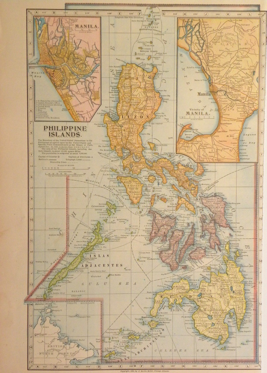
- 참고 자료
- Rohrbough, M. J. (1978). 《The Trans-Appalachian Frontier: People, Societies, and Institutions, 1775-1850》. Oxford University Press. ISBN 978-0-19-502209-4.
- Stein, Mark (2008). 《How the States Got Their Shapes》. New York: Smithsonian Books/Collins. ISBN 978-0-06-143138-8. OCLC 137324984.
- Van Zandt, Franklin K. (1976). 《Boundaries of the United States and the Several States: With Miscellaneous Geographic Information Concerning Areas, Altitudes, and Geographic Centers》. Washington, D.C.: U.S. Government Printing Office. OCLC 69426475.
- Walker, Francis A. (1874). 《Statistical Atlas of the United States》. [New York] J. Bien, lith. 65–79쪽. 2019년 4월 3일에 확인함.
| 개요 | .svg) | |
|---|---|---|
| 정치 | ||
| 정부 | ||
| 경제 | ||
| 사회·문화 | ||