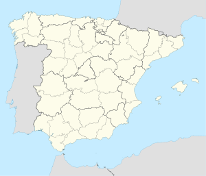
카세레스
| 카세레스 Cáceres | |||||
|---|---|---|---|---|---|
| |||||
| 행정 | |||||
| 국가 | |||||
| 지역 | 카세레스 주 | ||||
| 행정 구역 | 에스트레마두라 지방 | ||||
| 지리 | |||||
| 면적 | 1,750.33㎢ | ||||
| 인문 | |||||
| 인구 | 95,855명 (2014년) | ||||
| 인구 밀도 | 55명/㎢ | ||||
| 지역 부호 | |||||
| 우편번호 | 10001-10005 | ||||
| 웹사이트 | http://www.ayto-caceres.es/ | ||||

카세레스(스페인어: Cáceres)는 스페인 에스트레마두라 지방 카세레스 주의 주도이다. 면적은 1750.33km2이며, 인구는 91,606명(2007년)이다.
역사[편집]
기후[편집]
| Caceres 394m (1982-2010)의 기후 | |||||||||||||
|---|---|---|---|---|---|---|---|---|---|---|---|---|---|
| 월 | 1월 | 2월 | 3월 | 4월 | 5월 | 6월 | 7월 | 8월 | 9월 | 10월 | 11월 | 12월 | 연간 |
| 평균 일 최고 기온 °C (°F) | 12.0 (53.6) |
14.0 (57.2) |
17.7 (63.9) |
19.3 (66.7) |
23.7 (74.7) |
29.9 (85.8) |
33.7 (92.7) |
33.2 (91.8) |
28.8 (83.8) |
22.0 (71.6) |
15.9 (60.6) |
12.5 (54.5) |
21.9 (71.4) |
| 일 평균 기온 °C (°F) | 7.8 (46.0) |
9.3 (48.7) |
12.2 (54.0) |
13.8 (56.8) |
17.6 (63.7) |
22.9 (73.2) |
26.2 (79.2) |
26.0 (78.8) |
22.4 (72.3) |
17.0 (62.6) |
11.7 (53.1) |
8.7 (47.7) |
16.3 (61.3) |
| 평균 일 최저 기온 °C (°F) | 3.7 (38.7) |
4.7 (40.5) |
6.7 (44.1) |
8.3 (46.9) |
11.5 (52.7) |
16.0 (60.8) |
18.8 (65.8) |
18.7 (65.7) |
16.0 (60.8) |
11.9 (53.4) |
7.5 (45.5) |
4.9 (40.8) |
10.7 (51.3) |
| 평균 강수량 mm (인치) | 54 (2.1) |
48 (1.9) |
36 (1.4) |
52 (2.0) |
50 (2.0) |
20 (0.8) |
6 (0.2) |
7 (0.3) |
30 (1.2) |
77 (3.0) |
89 (3.5) |
77 (3.0) |
551 (21.7) |
| 평균 강수일수 (≥ 1 mm) | 7 | 7 | 5 | 7 | 7 | 3 | 1 | 1 | 4 | 8 | 8 | 8 | 64 |
| 평균 월간 일조시간 | 156 | 175 | 232 | 247 | 297 | 336 | 379 | 348 | 261 | 205 | 158 | 129 | 2,922 |
| 출처: Agencia Estatal de Meteorología[1] | |||||||||||||
The city of Cáceres is located in the province of Cáceres, in the Extremadura region of western central Spain. The city has a mediterranean climate (Köppen: Csa) which is tempered by its proximity to the Atlantic Ocean. In winter the average temperature does not exceed 14 °C (57 °F) maximum, reaching 8 °C (46 °F) minimum, with some frost. In summer the average maximum temperature is 34 °C (93 °F) and the average minimum is 19 °C (66 °F). Rainfall is abundant in the months of October, November, March, April and May, but very intermittent. [2]
각주[편집]
- ↑ “Standard Climate Values. Cáceres”. AEMet. October 2014. 2011년 11월 17일에 확인함.
- ↑ Clima en Cáceres 보관됨 23 9월 2010 - 웨이백 머신 protiempo.es
외부 링크[편집]
 위키미디어 공용에 카세레스 관련 미디어 분류가 있습니다.
| 이 글은 스페인에 관한 토막글입니다. 여러분의 지식으로 알차게 문서를 완성해 갑시다. |


