
파일:Manhattanhenge satellite view.svg

SVG 파일의 PNG 형식의 미리보기 크기: 400 × 600 픽셀. 다른 해상도: 160 × 240 픽셀 | 320 × 480 픽셀 | 512 × 768 픽셀 | 682 × 1,024 픽셀 | 1,365 × 2,048 픽셀
원본 파일 (SVG 파일, 실제 크기 512 × 768 픽셀, 파일 크기: 67 KB)

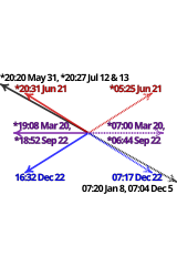
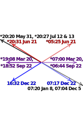
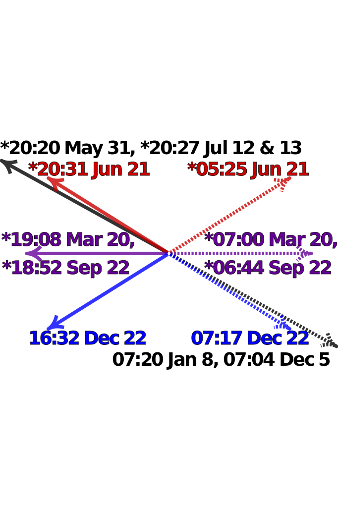
| 설명 | Satellite image of Manhattan, New York City centered on the intersection of Park Avenue and 34th Street, with directions and local times of sunrises (dotted lines) and sunsets (solid lines) on Manhattanhenge (black), summer solstice (red), equinoxes (purple) and winter solstice (blue) in 2011. Times marked with "*" have been adjusted for daylight saving. Data from http://www.esrl.noaa.gov/gmd/grad/solcalc/ and bitmap from http://earthobservatory.nasa.gov/IOTD/view.php?id=3678 and created by NASA. | |
| 날짜 | (UTC) | |
| 출처 |
|
|
| 저자 |
|

W3C-validity not checked.

|
이 SVG 파일은 편집 가능한 문자를 사용하므로 Inkscape나 Adobe Illustrator를 사용하여 쉽게 다른 언어로 번역할 수 있습니다. 여기를 참고하세요. 또한 텍스트 편집기를 이용하여 수동으로 파일을 번역할 수도 있습니다. |
| 이 그림은 수정된 그림으로, 원래 그림에서 디지털 변환이 이루어진 그림입니다. 수정 사항 : Update to 2012 and reduce clutter. 원래의 그림 : Manhattanhenge map.svg:
|
나는 아래 작품의 저작권자로서, 이 저작물을 다음과 같은 라이선스로 배포합니다:
이 파일은 크리에이티브 커먼즈 저작자표시-동일조건변경허락 3.0 Unported 라이선스로 배포됩니다.
- 이용자는 다음의 권리를 갖습니다:
- 공유 및 이용 – 저작물의 복제, 배포, 전시, 공연 및 공중송신
- 재창작 – 저작물의 개작, 수정, 2차적저작물 창작
- 다음과 같은 조건을 따라야 합니다:
- 저작자표시 – 적절한 저작자 표시를 제공하고, 라이센스에 대한 링크를 제공하고, 변경사항이 있는지를 표시해야 합니다. 당신은 합리적인 방식으로 표시할 수 있지만, 어떤 방식으로든 사용권 허가자가 당신 또는 당신의 사용을 지지하는 방식으로 표시할 수 없습니다.
- 동일조건변경허락 – 만약 당신이 이 저작물을 리믹스 또는 변형하거나 이 저작물을 기반으로 제작하는 경우, 당신은 당신의 기여물을 원저작물과 동일하거나 호환 가능한 라이선스에 따라 배포하여야 합니다.
기존 올리기 기록
This image is a derivative work of the following images:
- File:Manhattanhenge_map.svg licensed with Cc-by-sa-3.0
- 2011-07-18T23:55:44Z Cmglee 512x768 (71587 Bytes) Fix text.
- 2011-07-18T23:47:00Z Cmglee 512x768 (71599 Bytes) {{Information |Description=Map of Manhattan, New York City centered on the intersection of Park Avenue and 34th Street, with times and directions of sunrises (dotted line) and sunsets (solid line) in 2011. Times marked with "
Uploaded with derivativeFX
파일 역사
날짜/시간 링크를 클릭하면 해당 시간의 파일을 볼 수 있습니다.
| 날짜/시간 | 섬네일 | 크기 | 사용자 | 설명 | |
|---|---|---|---|---|---|
| 현재 | 2011년 7월 30일 (토) 09:48 | | 512 × 768 (67 KB) | Cmglee | Bold text and arrows. |
| 2011년 7월 30일 (토) 09:39 |  | 512 × 768 (67 KB) | Cmglee | Shrink text. | |
| 2011년 7월 30일 (토) 09:38 |  | 512 × 768 (67 KB) | Cmglee | Use 2011 dates, darken purple text and enlarge text. | |
| 2011년 7월 28일 (목) 13:38 |  | 512 × 768 (67 KB) | Cmglee | {{Information |Description=Satellite image of Manhattan, New York City centered on the intersection of Park Avenue and 34th Street, with directions and local times of sunrises (dotted lines) and sunsets (solid lines) on Manhattanhenge (black), summer sols |
이 파일을 사용하는 문서
다음 문서 1개가 이 파일을 사용하고 있습니다:
이 파일을 사용하고 있는 모든 위키의 문서 목록
다음 위키에서 이 파일을 사용하고 있습니다:
- en.wikipedia.org에서 이 파일을 사용하고 있는 문서 목록
- es.wikipedia.org에서 이 파일을 사용하고 있는 문서 목록
- fa.wikipedia.org에서 이 파일을 사용하고 있는 문서 목록
- id.wikipedia.org에서 이 파일을 사용하고 있는 문서 목록
- it.wikipedia.org에서 이 파일을 사용하고 있는 문서 목록
- ja.wikipedia.org에서 이 파일을 사용하고 있는 문서 목록
- ms.wikipedia.org에서 이 파일을 사용하고 있는 문서 목록
- pt.wikipedia.org에서 이 파일을 사용하고 있는 문서 목록
- ro.wikipedia.org에서 이 파일을 사용하고 있는 문서 목록
- www.wikidata.org에서 이 파일을 사용하고 있는 문서 목록
- zh.wikipedia.org에서 이 파일을 사용하고 있는 문서 목록