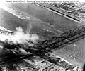
파일:Bombing of Yalu River Bridges at Sinuiju - Dandong Nov.1950.jpg

미리 보기 크기: 716 × 600 픽셀 다른 해상도: 287 × 240 픽셀 | 573 × 480 픽셀 | 740 × 620 픽셀
원본 파일 (740 × 620 픽셀, 파일 크기: 140 KB, MIME 종류: image/jpeg)
파일 역사
날짜/시간 링크를 클릭하면 해당 시간의 파일을 볼 수 있습니다.
| 날짜/시간 | 섬네일 | 크기 | 사용자 | 설명 | |
|---|---|---|---|---|---|
| 현재 | 2009년 10월 5일 (월) 12:31 |  | 740 × 620 (140 KB) | Rincewind42 | {{Information |Description={{en|1=Arial photograph of bomb damage during United States air attacs on the Yulu River Bridges between Sinuiju in North Korea and Dandong in China. The photograph is dated 18th November, 1950 though the source suggests that 14 |
이 파일을 사용하는 문서
이 파일을 사용하고 있는 모든 위키의 문서 목록
다음 위키에서 이 파일을 사용하고 있습니다:
- de.wikipedia.org에서 이 파일을 사용하고 있는 문서 목록
- en.wikipedia.org에서 이 파일을 사용하고 있는 문서 목록
- fr.wikipedia.org에서 이 파일을 사용하고 있는 문서 목록
- he.wikipedia.org에서 이 파일을 사용하고 있는 문서 목록
- it.wikipedia.org에서 이 파일을 사용하고 있는 문서 목록
- ja.wikipedia.org에서 이 파일을 사용하고 있는 문서 목록
- nds.wikipedia.org에서 이 파일을 사용하고 있는 문서 목록
- nl.wikipedia.org에서 이 파일을 사용하고 있는 문서 목록
- vi.wikipedia.org에서 이 파일을 사용하고 있는 문서 목록
- zh.wikipedia.org에서 이 파일을 사용하고 있는 문서 목록

