
파일:AA bedrock bedmap2.4960.tif
TIF 파일의 JPG 형식의 미리보기 크기: 800 × 450 픽셀. 다른 해상도: 320 × 180 픽셀 | 640 × 360 픽셀 | 1,024 × 576 픽셀 | 1,280 × 720 픽셀 | 1,920 × 1,080 픽셀
원본 파일 (1,920 × 1,080 픽셀, 파일 크기: 3.66 MB, MIME 종류: image/tiff)
파일 설명
| 설명 |
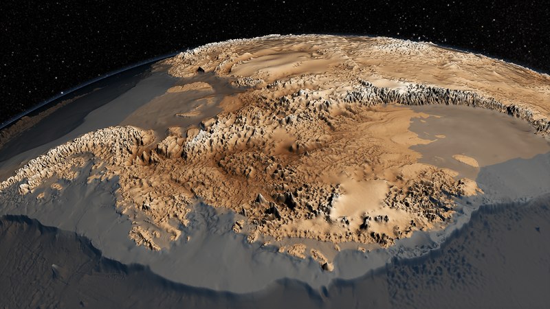
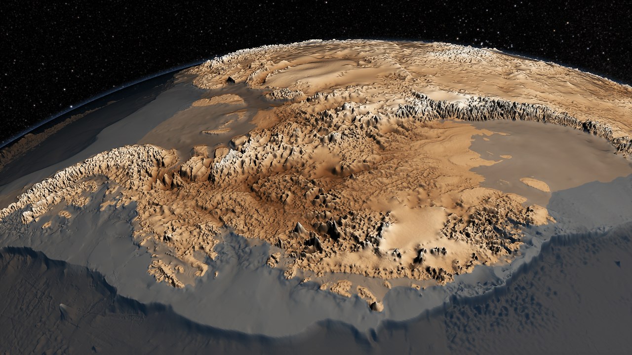
English: The topography of the bedrock under the Antarctic ice sheet is critical to understanding the dynamic motion of the ice sheet, its thickness and its influence on the surrounding ocean and global climate. In 2001, the British Antarctic Survey (BAS) released a map of the bed under the Antarctic Ice Sheet and the seabed extending out on to the continental shelf derived from data collected by an international consortium of scientists over the prior fifty years. The resulting dataset was called BEDMAP (or BEDMAP1).
In 2013, BAS released an update of the topographic dataset called BEDMAP2 that incorporates twenty-five million measurements taken over the past two decades from the ground, air and space. This animation compares the new BEDMAP2 dataset to the original BEDMAP1 dataset Source http://svs.gsfc.nasa.gov/cgi-bin/details.cgi?aid=4060 |
| 날짜 | |
| 출처 | http://www.nasa.gov/topics/earth/features/antarctic-map.html |
| 저자 | NASA Goddard's Scientific Visualization Studio |
라이선스
| 이 파일은 NASA에서 제작하였으므로 퍼블릭 도메인입니다. NASA의 저작권 정책에 따르면 NASA의 자료는 명시하지 않는 이상 저작권의 보호를 받지 않습니다. (Template:PD-USGov, 또는 NASA 저작권 정책 문서, JPL 그림 사용 정책을 참고하세요.) | ||
 |
주의사항:
|
파일 역사
날짜/시간 링크를 클릭하면 해당 시간의 파일을 볼 수 있습니다.
| 날짜/시간 | 섬네일 | 크기 | 사용자 | 설명 | |
|---|---|---|---|---|---|
| 현재 | 2022년 1월 16일 (일) 00:34 |  | 1,920 × 1,080 (3.66 MB) | Amitchell125 | lightened and brightened |
| 2014년 8월 2일 (토) 00:59 |  | 1,920 × 1,080 (2.64 MB) | Prokaryotes | User created page with UploadWizard |
이 파일을 사용하는 문서
다음 문서 1개가 이 파일을 사용하고 있습니다:
이 파일을 사용하고 있는 모든 위키의 문서 목록
다음 위키에서 이 파일을 사용하고 있습니다:
- ar.wikipedia.org에서 이 파일을 사용하고 있는 문서 목록
- de.wikipedia.org에서 이 파일을 사용하고 있는 문서 목록
- el.wikipedia.org에서 이 파일을 사용하고 있는 문서 목록
- en.wikipedia.org에서 이 파일을 사용하고 있는 문서 목록
- es.wikipedia.org에서 이 파일을 사용하고 있는 문서 목록
- fa.wikipedia.org에서 이 파일을 사용하고 있는 문서 목록
- fi.wikipedia.org에서 이 파일을 사용하고 있는 문서 목록
- hi.wikipedia.org에서 이 파일을 사용하고 있는 문서 목록
- it.wikipedia.org에서 이 파일을 사용하고 있는 문서 목록
- kn.wikipedia.org에서 이 파일을 사용하고 있는 문서 목록
- mk.wikipedia.org에서 이 파일을 사용하고 있는 문서 목록
- pl.wikipedia.org에서 이 파일을 사용하고 있는 문서 목록
- ru.wikipedia.org에서 이 파일을 사용하고 있는 문서 목록
- sl.wikipedia.org에서 이 파일을 사용하고 있는 문서 목록
- tr.wikipedia.org에서 이 파일을 사용하고 있는 문서 목록
- vi.wikipedia.org에서 이 파일을 사용하고 있는 문서 목록
- zh.wikipedia.org에서 이 파일을 사용하고 있는 문서 목록