GeoJSON: 두 판 사이의 차이
새 문서: 지오제이슨(GeoJSON) <ref>[https://tools.ietf.org/html/rfc7946 The GeoJSON Format]</ref>은 공간적이지 않은 속성과 함께 간단한 지형을 표현하기 위해 설계... |
(차이 없음)
|
2018년 8월 15일 (수) 08:32 판
지오제이슨(GeoJSON) [1]은 공간적이지 않은 속성과 함께 간단한 지형을 표현하기 위해 설계된 개방형 공개 표준 형식이다. 이것은 JSON인 자바스그립트 Object Notation을 기반으로한다.
지형지물(주소 및 위치), 선분 스트링(LineString,거리, 고속도로 및 경계등 정보를 담을수있는 Geocode 문자열), 다각형 (국가,도, 토지) 및 이러한 유형의 여러 부분으로 구성된 모음을 특징으로 한다. GeoJSON 기능은 물리적 세계의 엔티티만을 나타낼 필요는 없다. 예를 들어, 모바일 라우팅 및 네비게이션 애플리케이션은 GeoJSON을 사용하여 서비스 범위를 확장 기술할 수 있다. [2] 또한 GPX가 특정 목적을 위한 경로 정보 공유 도구로 활용되는것처럼 즉, 산악 등반이나 마운틴 바이크를 위한 루트 및 길안내 자료등으로 사용할수있다.
GeoJSON 형식은 공식 표준 조직이 아니라 인터넷 작업 그룹의 개발자에 의해 작성되고 유지된다는 점에서 다른 GIS 표준과 다르지만 XML을 기반으로 한GPX와 함께 사실상 표준처럼 사용된다.[3]
GeoJSON은 지형 공간 토폴로지를 인코딩하며 일반적으로 파일 크기가 더 작다.
GeoJSON의 주목할만한 계열은 TopoJSON이다.
워킹그룹
GeoJSON 형식의 워킹그룹과 토론은 2007년 3월에 시작되었으며 [4] 형식 지정은 2008년 6월에 마무리되었다.
2015년 4월 IETF(Internet Engineering Task Force)는 GeoJSON을 2016년 8월 RFC 7946으로 제안된 Geographic JSON 워킹그룹을 구성했다.[5]
예
{
  "type": "FeatureCollection",
  "features": [
    {
      "type": "Feature",
      "geometry": {
        "type": "Point",
        "coordinates": [102.0, 0.5]
      },
      "properties": {
        "prop0": "value0"
      }
    },
    {
      "type": "Feature",
      "geometry": {
        "type": "LineString",
        "coordinates": [
          [102.0, 0.0], [103.0, 1.0], [104.0, 0.0], [105.0, 1.0]
        ]
      },
      "properties": {
        "prop0": "value0",
        "prop1": 0.0
      }
    },
    {
      "type": "Feature",
      "geometry": {
        "type": "Polygon",
        "coordinates": [
          [
            [100.0, 0.0], [101.0, 0.0], [101.0, 1.0],
            [100.0, 1.0], [100.0, 0.0]
          ]
        ]
      },
      "properties": {
        "prop0": "value0",
        "prop1": { "this": "that" }
      }
    }
  ]
}
Geometries
| Type | Examples | |
|---|---|---|
| Point | 
|
{
    "type": "Point",
    "coordinates": [30, 10]
}
|
| LineString | 
|
{
    "type": "LineString",
    "coordinates": [
        [30, 10], [10, 30], [40, 40]
    ]
}
|
| Polygon | 
|
{
    "type": "Polygon",
    "coordinates": [
        [[30, 10], [40, 40], [20, 40], [10, 20], [30, 10]]
    ]
}
|

|
{
    "type": "Polygon",
    "coordinates": [
        [[35, 10], [45, 45], [15, 40], [10, 20], [35, 10]],
        [[20, 30], [35, 35], [30, 20], [20, 30]]
    ]
}
| |
| Type | Examples | |
|---|---|---|
| MultiPoint | 
|
{
    "type": "MultiPoint",
    "coordinates": [
        [10, 40], [40, 30], [20, 20], [30, 10]
    ]
}
|
| MultiLineString | 
|
{
    "type": "MultiLineString",
    "coordinates": [
        [[10, 10], [20, 20], [10, 40]],
        [[40, 40], [30, 30], [40, 20], [30, 10]]
    ]
}
|
| MultiPolygon | 
|
{
    "type": "MultiPolygon",
    "coordinates": [
        [
            [[30, 20], [45, 40], [10, 40], [30, 20]]
        ],
        [
            [[15, 5], [40, 10], [10, 20], [5, 10], [15, 5]]
        ]
    ]
}
|

|
{
    "type": "MultiPolygon",
    "coordinates": [
        [
            [[40, 40], [20, 45], [45, 30], [40, 40]]
        ],
        [
            [[20, 35], [10, 30], [10, 10], [30, 5], [45, 20], [20, 35]],
            [[30, 20], [20, 15], [20, 25], [30, 20]]
        ]
    ]
}
| |
지원 소프트웨어
GeoJSON은 OpenLayers[6], Leaflet, MapServer[7], Geoforge 소프트웨어[8] GeoServer, [9] GeoDjango[9], GDAL, [11] Safe Software FME 등 많은 매핑 및 GIS 소프트웨어 패키지에서 지원하고있다.[10] CartoDB[11]와 GDAL OGR 변환 라이브러리를 통해 형식을 처리하는 PostGIS[12]와 Mapnik[13]에서 GeoJSON을 사용할 수도 있다. Bing Maps, 야후!, HERE [14] 및 Google은 API 서비스에서 GeoJSON을 지원한다.
Google Maps JavaScript API v3은 2014년 3월 19일 기준으로 GeoJSON 데이터 레이어의 통합을 직접 지원한다.[15][16] Julia 언어의 경우 GeoJSON.jl 패키지를 사용할 수 있다.
GitHub은 GeoJSON 렌더링[17]과 Potrace GeoJSON 내보내기도 지원한다.
Geojson.io는 웹 브라우저에서 GeoJSON 렌더링 및 편집을 지원합니다.
TopoJSON 스키마
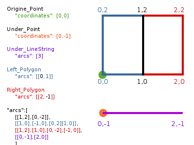
위도0 °와 경도 0 ° 근처에 GIS 모양이 주어지면 모든 메타 데이터를 포함하고있는 단순하지만 유효하고 완전한 topojson 파일의 'Polygon', ' LineString ', 'Point' ,'arc' 및 'properties'는 다음과 같이 정의할수있다.

{
  "type":"Topology",
  "transform":{
    "scale": [1,1],
    "translate": [0,0]
  },
  "objects":{
    "two-squares":{
      "type": "GeometryCollection",
      "geometries":[
        {"type": "Polygon", "arcs":[[0,1]],"properties": {"name": "Left_Polygon" }},
        {"type": "Polygon", "arcs":[[2,-1]],"properties": {"name": "Right_Polygon" }}
      ]
    },
    "one-line": {
      "type":"GeometryCollection",
      "geometries":[
        {"type": "LineString", "arcs": [3],"properties":{"name":"Under_LineString"}}
      ]
    },
    "two-places":{
      "type":"GeometryCollection",
      "geometries":[
        {"type":"Point","coordinates":[0,0],"properties":{"name":"Origine_Point"}},
        {"type":"Point","coordinates":[0,-1],"properties":{"name":"Under_Point"}}
      ]
    }
  },
  "arcs": [
    [[1,2],[0,-2]],
    [[1,0],[-1,0],[0,2],[1,0]],
    [[1,2],[1,0],[0,-2],[-1,0]],
    [[0,-1],[2,0]]
  ]
}
함께보기
참고
- ↑ The GeoJSON Format
- ↑ iOS Location and Maps Programming Guide
- ↑ The GeoJSON Discussion List
- ↑ March 2007 Archives by thread
- ↑ https://datatracker.ietf.org/wg/geojson/history/
- ↑ “Archived copy”. 2010년 3월 16일에 원본 문서에서 보존된 문서. 2010년 3월 16일에 확인함.
- ↑ http://mapserver.org/output/template_output.html
- ↑ http://leafletjs.com/reference.html#geojson
- ↑ “Archived copy”. 2009년 9월 7일에 원본 문서에서 보존된 문서. 2009년 10월 9일에 확인함.
- ↑ “Archived copy” (PDF). 2008년 7월 24일에 원본 문서 (PDF)에서 보존된 문서. 2008년 7월 24일에 확인함.
- ↑ http://developers.cartodb.com/documentation/cartodb-js.html
- ↑ “Archived copy” (PDF). 2010년 6월 1일에 원본 문서 (PDF)에서 보존된 문서. 2010년 6월 1일에 확인함.
- ↑ “Archived copy”. 2009년 5월 2일에 원본 문서에서 보존된 문서. 2009년 5월 2일에 확인함.
- ↑ https://developer.here.com/documentation/maps/topics_api/h-data-geojson-intro.html
- ↑ https://developers.google.com/maps/documentation/javascript/examples/layer-data-simple
- ↑ http://googledevelopers.blogspot.com/2014/03/maps-made-easier-geojson-in-javascript.html
- ↑ https://github.com/blog/1528-there-s-a-map-for-that
- (속성과 형상 데이터 표현이 가능한 GeoJSON,Taewook Kang)https://sites.google.com/site/bimprinciple/in-the-news/sogseong-gwahyeongsangdeiteopyohyeon-iganeunghangeojson
- (WHAT IS GPX?)http://www.topografix.com/gpx.asp
