
파일:New-Map-Francophone World.PNG

미리 보기 크기: 800 × 441 픽셀 다른 해상도: 320 × 176 픽셀 | 640 × 353 픽셀 | 1,024 × 564 픽셀 | 1,280 × 705 픽셀 | 2,664 × 1,468 픽셀
원본 파일 (2,664 × 1,468 픽셀, 파일 크기: 93 KB, MIME 종류: image/png)
파일 설명
| 설명 |
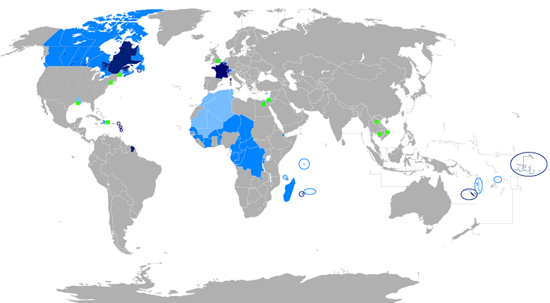
English: The French language and French creoles in the world
Regions where French or a French creole is the main language
Regions where it is an official language
Regions where it is a second language
Regions where it is a minority language
The following things have been changed from the old "Map-Francophone World.PNG":
To be modified :
Français : La langue française dans le monde
Langue maternelle
Langue officielle
Deuxième langue
Minorités francophones
Les choses suivantes ont été modifiées de l'ancien "Map-Frncophone World.PNG":
Proposition de modification : L'usage de la langue française est divers dans les pays d'Afrique subsaharienne. Par exemple, le français n'est pas la langue utilisée par défaut dans les rues sénégalaises. Tout au contraire, prétendre que le français n'est pas la langue maternelle des Gabonais reviendrait à dire que le français n'était rien de plus qu'une langue officielle dans la Bretagne des années cinquante. Ne connaissant pas la situation des autres pays, je laisse le soin à toute personne motivée de corriger cette erreur.
Català: La llengua francesa al món
Llengua materna
Llengua oficial
Segona Llengua
Minories francòfones |
| 날짜 | |
| 출처 | 자작 |
| 저자 | aaker |

|
이 그림은 벡터 그래픽 버전(SVG)이 있습니다. 래스터(비트맵) 그림 대신 벡터 그래픽 그림을 사용하는 것이 좋습니다.
File:New-Map-Francophone World.PNG → File:New-Map-Francophone World.svg
|
 |
라이선스
| 나는 이 작품의 저작권자로서, 이 작품을 퍼블릭 도메인으로 모두에게 공개합니다. 이 공개 선언은 전 세계적으로 유효합니다. 만약 저작권의 포기가 법률적으로 가능하지 않은 경우, 나는 이 작품을 법적으로 허용되는 한도 내에서 누구나 자유롭게 어떤 목적으로도 제한없이 사용할 수 있도록 허용합니다. |
파일 역사
날짜/시간 링크를 클릭하면 해당 시간의 파일을 볼 수 있습니다.
| 날짜/시간 | 섬네일 | 크기 | 사용자 | 설명 | |
|---|---|---|---|---|---|
| 현재 | 2023년 7월 30일 (일) 09:15 | | 2,664 × 1,468 (93 KB) | Riad Salih | Western Sahara is an old Spanish colony, and French is not commonly used there. |
| 2023년 7월 30일 (일) 09:10 |  | 2,664 × 1,468 (93 KB) | Riad Salih | Since July 2023, French is no longer an official language in Mali, but a language of work. | |
| 2023년 4월 30일 (일) 15:49 |  | 2,664 × 1,468 (205 KB) | Moalli | Remove green square in middle of Mediterranean, no country located there | |
| 2023년 3월 16일 (목) 07:50 |  | 2,664 × 1,468 (105 KB) | Kwamikagami | update some per WP-en article, though this map not used much anymore | |
| 2019년 8월 9일 (금) 19:21 |  | 2,664 × 1,468 (120 KB) | Benderban01 | Reverted to version as of 15:28, 17 July 2018 (UTC) | |
| 2019년 8월 6일 (화) 18:07 |  | 2,664 × 1,468 (119 KB) | Benderban01 | Removed the small thing on ontario. | |
| 2019년 8월 6일 (화) 18:01 |  | 2,664 × 1,468 (119 KB) | Benderban01 | Removed 8 provinces where french is not the official language, there 3 territorries which will spoke minority. | |
| 2018년 7월 18일 (수) 00:28 |  | 2,664 × 1,468 (120 KB) | Maphobbyist | Reverted to version as of 18:46, 4 January 2018 (UTC) | |
| 2018년 6월 27일 (수) 18:53 |  | 2,664 × 1,468 (100 KB) | Motiss | ||
| 2018년 6월 27일 (수) 18:50 |  | 2,664 × 1,468 (120 KB) | Motiss | Reverted to version as of 18:46, 4 January 2018 (UTC) |
이 파일을 사용하는 문서
이 파일을 사용하는 문서가 없습니다.
이 파일을 사용하고 있는 모든 위키의 문서 목록
다음 위키에서 이 파일을 사용하고 있습니다:
- de.wikipedia.org에서 이 파일을 사용하고 있는 문서 목록
- en.wikipedia.org에서 이 파일을 사용하고 있는 문서 목록
- Category:Wikipedians in Luxembourg
- Category:Wikipedians in Switzerland
- Category:WikiProject Luxembourg participants
- Category:WikiProject Switzerland participants
- Category:Swiss Wikipedians
- Talk:English language/Archive 18
- Talk:French language/Archive 3
- Category:Wikipedians interested in Luxembourg
- Category:Wikipedians interested in Switzerland
- Category:Luxembourg Wikipedians
- Template:Portal/doc/all
- Wikipedia:Reference desk/Archives/Humanities/2013 October 5
- User:Matt Fitzpatrick/portal images
- Wikipedia:Userboxes/Location/Luxembourg
- Wikipedia:Userboxes/Location/Switzerland
- Template:User Luxembourg/cat
- Template:User Switzerland/cat
- Template:User Luxembourg/boxes
- Template:User Switzerland/boxes
- es.wikipedia.org에서 이 파일을 사용하고 있는 문서 목록
- fi.wikipedia.org에서 이 파일을 사용하고 있는 문서 목록
- fr.wikipedia.org에서 이 파일을 사용하고 있는 문서 목록
- Discussion:Francophonie
- Discussion utilisateur:Le sotré
- Liste des pays ayant le français pour langue officielle
- Wikipédia:Le Bistro/24 février 2008
- Utilisateur:Brochon99/Bac à sable 5/Documentation
- Wikipédia:Le Bistro/18 décembre 2009
- Utilisateur:Kimdime/stats
- Utilisateur:Ygdrasil/http://Liste langue par nbr locuteur
- Utilisateur:Televido/Récolte
- Wikipédia:Le Bistro/25 juillet 2017
- Wikipédia:Le Bistro/30 juillet 2017
- fr.wikinews.org에서 이 파일을 사용하고 있는 문서 목록
- fr.wiktionary.org에서 이 파일을 사용하고 있는 문서 목록
- jv.wikipedia.org에서 이 파일을 사용하고 있는 문서 목록
- km.wikipedia.org에서 이 파일을 사용하고 있는 문서 목록
- nl.wikipedia.org에서 이 파일을 사용하고 있는 문서 목록
- so.wikipedia.org에서 이 파일을 사용하고 있는 문서 목록
- tum.wikipedia.org에서 이 파일을 사용하고 있는 문서 목록