
파일:Meyers b9 s0067b.jpg
미리 보기 크기: 457 × 599 픽셀 다른 해상도: 183 × 240 픽셀 | 366 × 480 픽셀 | 586 × 768 픽셀 | 781 × 1,024 픽셀 | 1,562 × 2,048 픽셀
원본 파일 (1,562 × 2,048 픽셀, 파일 크기: 594 KB, MIME 종류: image/jpeg)
파일 설명
| 설명 |
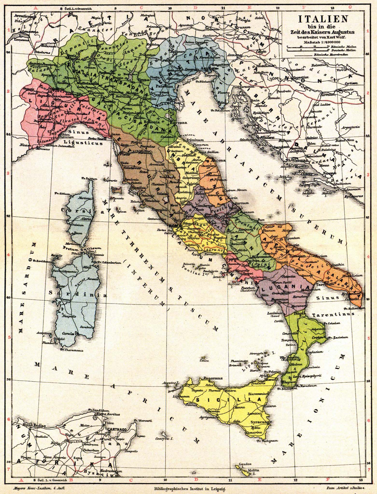
English: Old map of Italy and Austria, in time period of Caesar Augustus (27 BCE - AD 14). The map has labels in Latin & German, from Volume 9 of German encyclopedia Meyers Konversations-Lexikon.
Deutsch: Italien bis in die Zeit des Kaisers Augustus bearbeitet von Karl Wolf. Maßstab 1 : 4 900 000. |
| 날짜 | 1885년 - 1890년 |
| 출처 |
Meyers Konversations-Lexikon, Band 9 http://susi.e-technik.uni-ulm.de:8080/Meyers2/index/index.html |
| 저자 | Karl Wolf |
| 다른 버전 |
Register:
|


라이선스
| This image comes from the 4th edition of Meyers Konversationslexikon (1885–90). The copyrights have expired and this image is in the public domain. |
|
이 작품은 미국, 그리고 저작권 보호 기간이 저작자 사후 100년, 또는 그 이하인 모든 국가에서 퍼블릭 도메인입니다. 이 작품은 1929년 1월 1일 이전에 출판하였으므로 미국에서 퍼블릭 도메인입니다. | |
| 이 저작물은 모든 저작인접권을 포함한 저작권법하의 규제로부터 자유로운 것으로 확인되었습니다. | |
파일 역사
날짜/시간 링크를 클릭하면 해당 시간의 파일을 볼 수 있습니다.
| 날짜/시간 | 섬네일 | 크기 | 사용자 | 설명 | |
|---|---|---|---|---|---|
| 현재 | 2015년 8월 1일 (토) 04:33 | | 1,562 × 2,048 (594 KB) | Mapmarks | higher resolution |
| 2007년 8월 31일 (금) 02:23 |  | 800 × 1,049 (248 KB) | Red Rooster | {{Information |Description={{PD-Meyers-pages|9}} |Source=http://susi.e-technik.uni-ulm.de:8080/Meyers2/index/index.html |Date= |Author= |Permission=Author died more than 70 years ago - public domain |other_versions= }} {{PD-old}} |
이 파일을 사용하는 문서
다음 문서 1개가 이 파일을 사용하고 있습니다:
이 파일을 사용하고 있는 모든 위키의 문서 목록
다음 위키에서 이 파일을 사용하고 있습니다:
- af.wikipedia.org에서 이 파일을 사용하고 있는 문서 목록
- ast.wikipedia.org에서 이 파일을 사용하고 있는 문서 목록
- ba.wikipedia.org에서 이 파일을 사용하고 있는 문서 목록
- de.wikipedia.org에서 이 파일을 사용하고 있는 문서 목록
- de.wikisource.org에서 이 파일을 사용하고 있는 문서 목록
- en.wikipedia.org에서 이 파일을 사용하고 있는 문서 목록
- eo.wikivoyage.org에서 이 파일을 사용하고 있는 문서 목록
- es.wikipedia.org에서 이 파일을 사용하고 있는 문서 목록
- fr.wikipedia.org에서 이 파일을 사용하고 있는 문서 목록
- hu.wikipedia.org에서 이 파일을 사용하고 있는 문서 목록
- it.wikipedia.org에서 이 파일을 사용하고 있는 문서 목록
- ja.wikipedia.org에서 이 파일을 사용하고 있는 문서 목록
- lv.wikipedia.org에서 이 파일을 사용하고 있는 문서 목록
- pl.wikipedia.org에서 이 파일을 사용하고 있는 문서 목록
- pt.wikipedia.org에서 이 파일을 사용하고 있는 문서 목록
- ru.wikipedia.org에서 이 파일을 사용하고 있는 문서 목록
- sl.wikipedia.org에서 이 파일을 사용하고 있는 문서 목록
- te.wikipedia.org에서 이 파일을 사용하고 있는 문서 목록
- tr.wikipedia.org에서 이 파일을 사용하고 있는 문서 목록
- zh.wikipedia.org에서 이 파일을 사용하고 있는 문서 목록