
파일:Mercator Septentrionalium Terrarum descriptio.jpg
미리 보기 크기: 646 × 599 픽셀 다른 해상도: 259 × 240 픽셀 | 517 × 480 픽셀 | 828 × 768 픽셀 | 1,104 × 1,024 픽셀 | 2,208 × 2,048 픽셀 | 3,261 × 3,025 픽셀
원본 파일 (3,261 × 3,025 픽셀, 파일 크기: 3.04 MB, MIME 종류: image/jpeg)
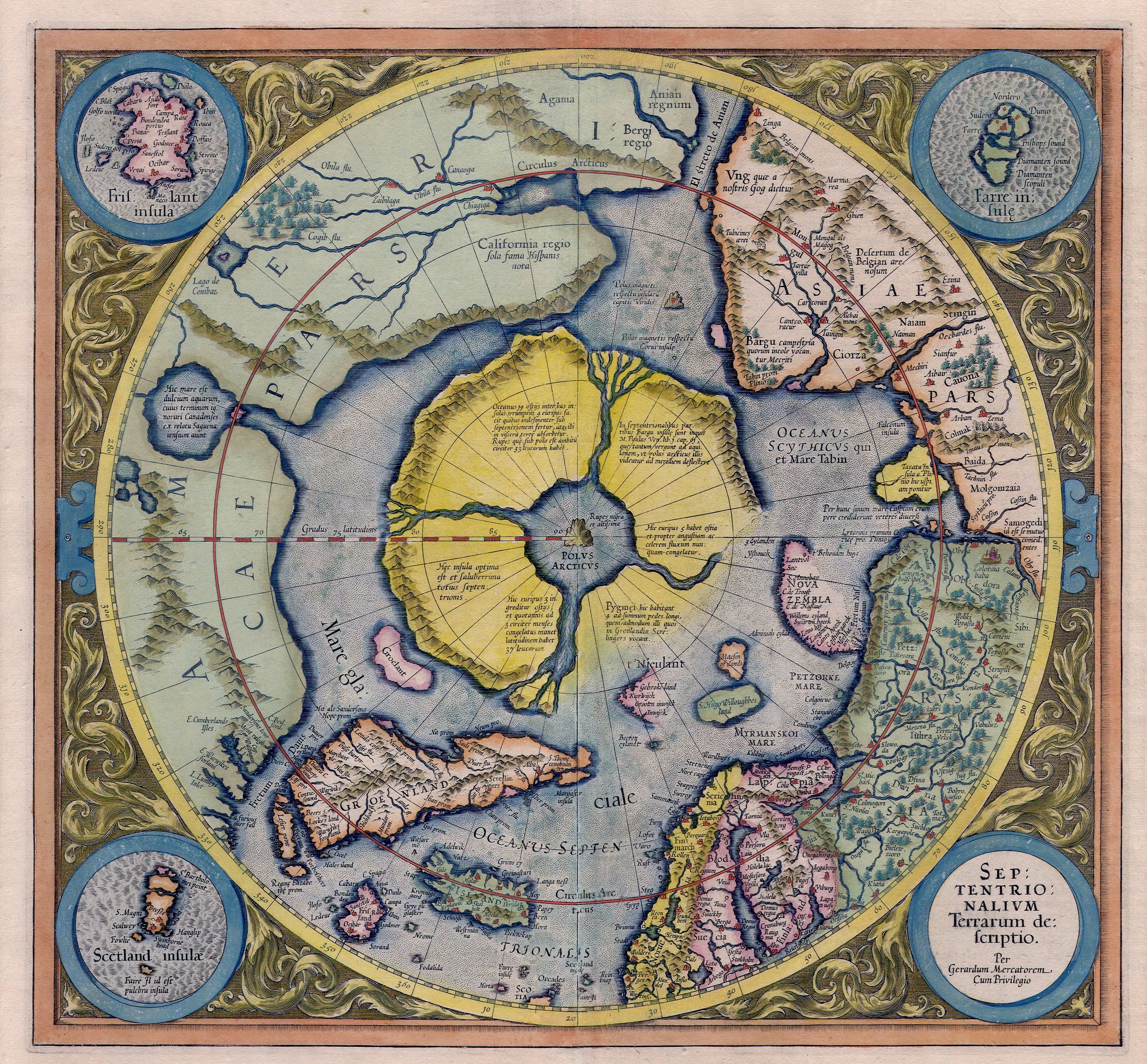
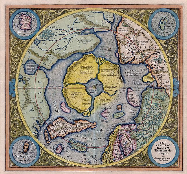
| 설명 | Mercator: Septentrionalium Terrarum descriptio. A map of the North Pole. |
| 날짜 | |
| 출처 | Helmink Antique Maps |
| 저자 | Gerardus Mercator, with addition of data from Willem Barentsz voyages |
| 저작권 (이 파일을 인용하기) |
PD because of age |
|
이 작품은 미국, 그리고 저작권 보호 기간이 저작자 사후 100년, 또는 그 이하인 모든 국가에서 퍼블릭 도메인입니다. | |
| 이 저작물은 모든 저작인접권을 포함한 저작권법하의 규제로부터 자유로운 것으로 확인되었습니다. | |
| 주석 | 이 이미지에는 주석이 있습니다: 공용에서 주석을 보기 |
파일 역사
날짜/시간 링크를 클릭하면 해당 시간의 파일을 볼 수 있습니다.
| 날짜/시간 | 섬네일 | 크기 | 사용자 | 설명 | |
|---|---|---|---|---|---|
| 현재 | 2007년 5월 6일 (일) 19:13 | | 3,261 × 3,025 (3.04 MB) | Jan Arkesteijn | {{Information |Description=Mercator: Septentrionalium Terrarum descriptio. A map of the northpole. |Source=[http://www.helmink.com/Antique_Map_Mercator_Arctic/ Helmink Antique Maps] |Date=1595 - 1623 |Author=Gerardus Mercator |Permission=PD because of age |
이 파일을 사용하는 문서
다음 문서 1개가 이 파일을 사용하고 있습니다:
이 파일을 사용하고 있는 모든 위키의 문서 목록
다음 위키에서 이 파일을 사용하고 있습니다:
- bg.wikipedia.org에서 이 파일을 사용하고 있는 문서 목록
- cs.wikipedia.org에서 이 파일을 사용하고 있는 문서 목록
- cv.wikipedia.org에서 이 파일을 사용하고 있는 문서 목록
- de.wikipedia.org에서 이 파일을 사용하고 있는 문서 목록
- en.wikipedia.org에서 이 파일을 사용하고 있는 문서 목록
- eo.wikipedia.org에서 이 파일을 사용하고 있는 문서 목록
- es.wikipedia.org에서 이 파일을 사용하고 있는 문서 목록
- fi.wikipedia.org에서 이 파일을 사용하고 있는 문서 목록
- Käyttäjä:Johannes sankari
- Wikipedia:Käyttäjälaatikot/Aihealueet
- Malline:Käyttäjä Mytologiat
- Käyttäjä:Oan
- Käyttäjä:DLS
- Käyttäjä:Elenloth
- Käyttäjä:Mstislav Ivanovich
- Käyttäjä:Mikko95
- Käyttäjä:Butthead Rotten
- Käyttäjä:Fengshuimestari
- Käyttäjä:Heinasirkka
- Käyttäjä:IruPiru
- Käyttäjä:101090ABC/Käyttäjälaatikot ja kielitaito
- Käyttäjä:Rougar
- Käyttäjä:Röhmöfantti
- Käyttäjä:Zemant
- Käyttäjä:Capisce~fiwiki
- Käyttäjä:Ilarius
- Käyttäjä:Dragomir~fiwiki
- Käyttäjä:Veera Verbi
- Käyttäjä:Saijanurmi
- Käyttäjä:Mumintrollet202
- Käyttäjä:PowerBUL
- Käyttäjä:Jyri Nieminen
- Käyttäjä:Luurankosoturi
- Käyttäjä:Talvipäivänseisaus
- Käyttäjä:Aenoran
- fr.wikipedia.org에서 이 파일을 사용하고 있는 문서 목록
- hu.wikipedia.org에서 이 파일을 사용하고 있는 문서 목록
- hy.wikipedia.org에서 이 파일을 사용하고 있는 문서 목록
- id.wikipedia.org에서 이 파일을 사용하고 있는 문서 목록
- is.wikipedia.org에서 이 파일을 사용하고 있는 문서 목록
- it.wikipedia.org에서 이 파일을 사용하고 있는 문서 목록
이 파일의 더 많은 사용 내역을 봅니다.