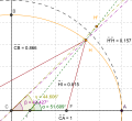
파일:Geocentric vs geodetic latitude with elevation.svg
보이기

SVG 파일의 PNG 형식의 미리보기 크기: 300 × 275 픽셀. 다른 해상도: 262 × 240 픽셀 | 524 × 480 픽셀 | 838 × 768 픽셀 | 1,117 × 1,024 픽셀 | 2,234 × 2,048 픽셀
원본 파일 (SVG 파일, 실제 크기 300 × 275 픽셀, 파일 크기: 70 KB)
파일 역사
날짜/시간 링크를 클릭하면 해당 시간의 파일을 볼 수 있습니다.
| 날짜/시간 | 섬네일 | 크기 | 사용자 | 설명 | |
|---|---|---|---|---|---|
| 현재 | 2013년 3월 28일 (목) 00:37 |  | 300 × 275 (70 KB) | Citypeek | Cleanup of file. Valid SVG now. |
| 2008년 8월 7일 (목) 08:36 |  | 300 × 275 (93 KB) | Datumizer | changed style of lines | |
| 2008년 8월 7일 (목) 08:35 |  | 300 × 275 (93 KB) | Datumizer | matched color of lines to color of angles | |
| 2008년 8월 6일 (수) 13:39 |  | 300 × 275 (95 KB) | Datumizer | image dimensions are now more convenient | |
| 2008년 8월 6일 (수) 13:33 |  | 339 × 311 (95 KB) | Datumizer | changed color of one of the angle measurements to purple | |
| 2008년 8월 6일 (수) 13:31 |  | 339 × 311 (95 KB) | Datumizer | angle measurements were overlapping | |
| 2008년 8월 6일 (수) 13:30 |  | 339 × 311 (95 KB) | Datumizer | Less wasted space, more readable in thumbnail sizes. | |
| 2008년 3월 8일 (토) 12:00 |  | 830 × 633 (59 KB) | Datumizer | Angle markers were too hard to distinguish. | |
| 2008년 2월 17일 (일) 05:15 |  | 830 × 633 (61 KB) | Datumizer | Image was too small. | |
| 2008년 2월 17일 (일) 05:00 |  | 415 × 316 (61 KB) | Datumizer | {{Information |Description=Shows how corrections have to be made for height (altitude) when converting from geodetic to geocentric coordinates. |Source=self-made |Date=2008-02-16 |Author= SharkD |Permission= |other_versions= }} |
이 파일을 사용하는 문서
다음 문서 1개가 이 파일을 사용하고 있습니다:
이 파일을 사용하고 있는 모든 위키의 문서 목록
다음 위키에서 이 파일을 사용하고 있습니다:
- ko.wikiversity.org에서 이 파일을 사용하고 있는 문서 목록
- vi.wikipedia.org에서 이 파일을 사용하고 있는 문서 목록


