본문으로 이동

파일:Assassination attempt of Donald Trump diagram.svg

문서 내용이 다른 언어로는 지원되지 않습니다.
위키백과, 우리 모두의 백과사전.

원본 파일(SVG 파일, 실제 크기 512 × 486 픽셀, 파일 크기: 25 KB)

이 그림을 로 렌더합니다.

파일 설명

묘사
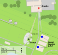
العربية: مخطط يظهر أماكن تواجد منفذ الهجوم توامس ماثيو كروكس (اللون الأحمر)، ودونالد ترامب (اللون الأسود)، وفرقة مكافحة الاعتداء للخدمة السرية (اللون الأزرق) خلال محاولة اغتيال ترامب في يوليو 2024
Deutsch: Ein Diagramm, das die ungefähren Standorte des Schützen Thomas Matthew Crooks (rot), Donald Trumps (schwarz), des Scharfschützenteams des Secret Service (blau), des tödlich verletzten Corey Comperatore (dunkelrot) und der schwer verletzten Opfer (gelb) während des versuchten Attentats auf Donald Trump im Juli 2024 zeigt
English: A diagram illustrating the approximate locations of shooter Thomas Matthew Crooks (red), Donald Trump (black), the Secret Service Counter Sniper Team (blue), fatally injured Corey Comperatore (dark red), and critically injured victims (yellow) during the attempted assassination of Donald Trump in July 2024
Français : Un diagramme illustrant les emplacements approximatifs de Thomas Matthew Crooks (rouge), Donald Trump (noir) et l'équipe de contre-embuscade (E.C.E) du Secret Service (bleu)
Nederlands: Plattegrond van de bijeenkomst tijdens de moordpoging van Donald Trump met geschatte locaties van Trump (zwart), Crooks (rood), en de tegenaanvalteam van de geheime dienst (SSCAT) (blauw)
이 지도는 오픈스트리트맵 프로젝트의 커뮤니티가 수집한 데이터를 바탕으로 만들어졌습니다. 이 지도는 미완성이며 오류가 있을 수 있습니다. 이 지도에만 의존하여 이동 계획 작성 등을 하지 말아 주십시오.
SVG 발전
InfoField
 
SVG 파일의 소스 코드 문법이 올바릅니다.
 
벡터 그림Inkscape(으)로 제작되었습니다.
 
 이 SVG 지도는은 SVG의 <switch> 요소를 사용하는 것으로 번역되어 있습니다: 모든 번역은 동일 파일 안에 저장되어 있습니다.
날짜
출처 openstreetmap.org
창작자
원본:
벡터:
OpenStreetMap 기여자
저작권
(이 파일을 인용하기)

OpenStreetMap data is available under the Open Database License (details). Standard style map tiles are licensed as ODbL Produced Works.

This work contains information from OpenStreetMap, which is made available under the Open Database License (ODbL).

The ODbL does not require any particular license for maps produced from ODbL data. Prior to 1 August 2020, map tiles produced by the OpenStreetMap Foundation were licensed under the CC-BY-SA-2.0 license. Maps produced by other people may be subject to other licences.

지리 참고 Wikimaps Warper에서 지도 지리를 참고하기 부적절한 경우에 숨기려면 warp_status = skip로 설정하세요.

References

Sources of labeled locations:[1][2][3]

Location of another CS team on second building:[4]

Location of victims:[5]

Approximate measurements of stage, bleachers, and seats:[6][7]

Counter Sniper team:[8][9]

  1. (2024-07-13). "Shooting at a Trump Rally in Pennsylvania: Maps and Photos". The New York Times. ISSN 0362-4331.
  2. Trump injured, rushed from stage after shooter fired on his Pennsylvania rally (in en). NBC News (2024-07-13). Archived from the original on July 14, 2024. Retrieved on 2024-07-14.
  3. Sky News (2024-07-14). Trump shooting: Gunman identified as video shows body and rifle on roof. Sky News. Retrieved on 2024-07-15.
  4. The Wall Street Journal (2024-07-14). How Donald Trump’s Attempted Assassination Unfolded. YouTube. Retrieved on 2024-07-14.
  5. Storyful News & Weather (2024-07-14). Bloodied Person Carried Away From Stands Following Shooting at Trump Rally. YouTube. Retrieved on 2024-07-15.
  6. Aerial footage of scene after shooting at Trump rally in Butler, Pennsylvania. WFXG FOX54 (2024-07-13). Retrieved on 2024-07-14.
  7. https://media-cldnry.s-nbcnews.com/image/upload/q_auto:best/rockcms/2024-07/240714-donald-trump-butler-rally-shooting-aftermath-wm-129p-6af977.jpg
  8. United States Secret Service (n.d.). Special Operations Division. Retrieved on 2024-07-15.
  9. United States Secret Service (2024-07-15). Statement From U.S. Secret Service Director Kimberly Cheatle.

라이선스

This work contains information from OpenStreetMap, which is made available under the Open Database License (ODbL).

The ODbL does not require any particular license for maps produced from ODbL data. Prior to 1 August 2020, map tiles produced by the OpenStreetMap Foundation were licensed under the CC-BY-SA-2.0 license. Maps produced by other people may be subject to other licences.

설명

이 파일이 나타내는 바에 대한 한 줄 설명을 추가합니다
A diagram illustrating the approximate locations of Thomas Matthew Crooks (red), Donald Trump (black), and the Secret Service Counter Sniper Team (blue)

image/svg+xml

파일 역사

날짜/시간 링크를 클릭하면 해당 시간의 파일을 볼 수 있습니다.

(최신 | 오래됨) (다음 10개 | ) (10 | 20 | 50 | 100 | 250 | 500) 보기
날짜/시간섬네일크기사용자설명
현재2024년 7월 16일 (화) 07:432024년 7월 16일 (화) 07:43 판의 섬네일512 × 486 (25 KB)GlrxCST to CS; SS uses CS. // Editing SVG source code using c:User:Rillke/SVGedit.js
2024년 7월 16일 (화) 07:382024년 7월 16일 (화) 07:38 판의 섬네일512 × 486 (25 KB)GlrxC.A.T. to CST // Editing SVG source code using c:User:Rillke/SVGedit.js
2024년 7월 16일 (화) 04:242024년 7월 16일 (화) 04:24 판의 섬네일512 × 486 (25 KB)ЂидоFile uploaded using svgtranslate tool (https://svgtranslate.toolforge.org/). Added translation for sr-cyrl.
2024년 7월 16일 (화) 03:172024년 7월 16일 (화) 03:17 판의 섬네일512 × 486 (23 KB)Glrxrestore systemLanguage=lij
2024년 7월 16일 (화) 03:052024년 7월 16일 (화) 03:05 판의 섬네일512 × 486 (22 KB)Glrxmy changes + it translation
2024년 7월 16일 (화) 02:592024년 7월 16일 (화) 02:59 판의 섬네일793 × 753 (24 KB)GlrxReverted to version as of 17:44, 15 July 2024 (UTC)
2024년 7월 16일 (화) 02:582024년 7월 16일 (화) 02:58 판의 섬네일512 × 486 (21 KB)Glrxdel width height; +clipPath; increase font size from 4 to 10px
2024년 7월 16일 (화) 02:442024년 7월 16일 (화) 02:44 판의 섬네일793 × 753 (24 KB)AshoppioFile uploaded using svgtranslate tool (https://svgtranslate.toolforge.org/). Added translation for it.
2024년 7월 16일 (화) 02:432024년 7월 16일 (화) 02:43 판의 섬네일793 × 753 (23 KB)AshoppioFile uploaded using svgtranslate tool (https://svgtranslate.toolforge.org/). Added translation for lij.
2024년 7월 16일 (화) 02:412024년 7월 16일 (화) 02:41 판의 섬네일793 × 753 (21 KB)Glrxspell; merge legend; +en; width height and viewBox still unusual
(최신 | 오래됨) (다음 10개 | ) (10 | 20 | 50 | 100 | 250 | 500) 보기

다음 문서 1개가 이 파일을 사용하고 있습니다:

이 파일을 사용하고 있는 모든 위키의 문서 목록

다음 위키에서 이 파일을 사용하고 있습니다:

메타데이터