
파일:Alfred Grohs zur Revolution 1918 1919 in Berlin Große Frankfurter Straße Ecke Lebuser Straße Barrikade Kampf während der Novemberrevolution in Berlin 02 Bildseite Schaulustige.jpg

미리 보기 크기: 386 × 599 픽셀 다른 해상도: 154 × 240 픽셀 | 309 × 480 픽셀 | 495 × 768 픽셀 | 660 × 1,024 픽셀 | 2,088 × 3,240 픽셀
원본 파일 (2,088 × 3,240 픽셀, 파일 크기: 8.97 MB, MIME 종류: image/jpeg)
파일 설명
| 설명 |
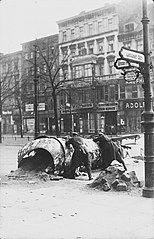
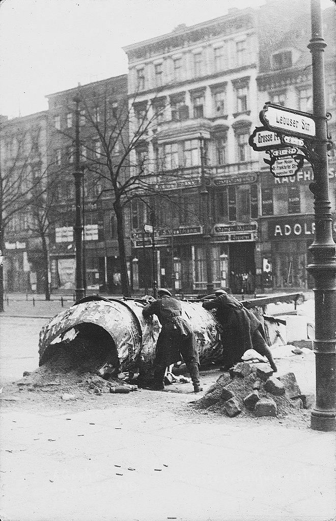
Deutsch: Erst in der Vergrößerung dieses Scans der originalen Echtfoto-Ansichtskarte des Urhebers Alfred Grohs werden Details der Szenerie erkennbar, die eine andere Betrachtungsweise zulassen: Wenn auch die Schärfe der ursprünglichen Aufnahme vergleichsweise enttäuschend ist, so ist die versammelte Gruppe von Schaulustigen im Hauseingang neben dem Bekleidungsgeschäft ("Damen-Mäntel") an der "Große Frankfurter Straße" ein Indiz dafür, dass die auf dem Foto scheinbar zu sehende aktuelle Kampfhandlung der Barrikadenkämpfe während der Novemberrevolution offenbar nicht mehr lebensgefährlich ist. Eine nachgestellte Aufnahme, während der Eltern ihre Kinder zuschauen lassen? Der Erkenntnisgewinn gegenüber dem vom deutschen Bundesarchiv gestifteten Digitalisat ist jedoch enorm: Neben weiteren Details konnte über Wikimedia Commons bisher sowohl der Name des Fotografen als auch der genaue Ort der Aufnahme (auf der heutigen Karl-Marx-Allee) identifiziert werden.
English: Only in the enlargement of this scan of the original real photo-viewing map by the author Alfred Grohs do details of the scenery become discernible that allow a different way of looking at it: Even if the sharpness of the original photograph is comparatively disappointing, the gathered group of onlookers in the building entrance next to the clothing shop ("Ladies' Coats") on "Große Frankfurter Straße" is an indication that the actual fighting action of the barricade fights during the November Revolution that can apparently be seen in the photograph is apparently no longer life-threatening. A re-enacted shot of parents letting their children watch? However, the gain in knowledge compared to the digital copy donated by the German Federal Archives is enormous: in addition to other details, it has so far been possible to identify both the name of the photographer and the exact location of the photograph (on today's Karl-Marx-Allee) via Wikimedia Commons. |
| 날짜 | 촬영 날짜: 1919년 1월 |
| 출처 | Scan vom Original: Bernd Schwabe in Hannover |
| 저자 | Alfred Grohs |
| 다른 버전 |
|


| 카메라 위치 | | 이 지역의 다른 사진을 보기: OpenStreetMap |
|---|
라이선스
이 파일은 크리에이티브 커먼즈 저작자표시 3.0 Unported 라이선스로 배포됩니다.
- 이용자는 다음의 권리를 갖습니다:
- 공유 및 이용 – 저작물의 복제, 배포, 전시, 공연 및 공중송신
- 재창작 – 저작물의 개작, 수정, 2차적저작물 창작
- 다음과 같은 조건을 따라야 합니다:
- 저작자표시 – 적절한 저작자 표시를 제공하고, 라이센스에 대한 링크를 제공하고, 변경사항이 있는지를 표시해야 합니다. 당신은 합리적인 방식으로 표시할 수 있지만, 어떤 방식으로든 사용권 허가자가 당신 또는 당신의 사용을 지지하는 방식으로 표시할 수 없습니다.
파일 역사
날짜/시간 링크를 클릭하면 해당 시간의 파일을 볼 수 있습니다.
| 날짜/시간 | 섬네일 | 크기 | 사용자 | 설명 | |
|---|---|---|---|---|---|
| 현재 | 2022년 11월 16일 (수) 19:02 | | 2,088 × 3,240 (8.97 MB) | 1970gemini | endschleiart |
| 2018년 6월 14일 (목) 21:39 |  | 2,088 × 3,240 (2.31 MB) | 1970gemini | geautobalanced | |
| 2013년 11월 1일 (금) 08:55 |  | 2,088 × 3,240 (8.97 MB) | Ras67 | losslessly cropped with Jpegcrop | |
| 2013년 6월 4일 (화) 17:45 |  | 2,171 × 3,352 (10.1 MB) | Bernd Schwabe in Hannover |
이 파일을 사용하는 문서
다음 문서 2개가 이 파일을 사용하고 있습니다:
이 파일을 사용하고 있는 모든 위키의 문서 목록
다음 위키에서 이 파일을 사용하고 있습니다:
- ar.wikipedia.org에서 이 파일을 사용하고 있는 문서 목록
- arz.wikipedia.org에서 이 파일을 사용하고 있는 문서 목록
- ast.wikipedia.org에서 이 파일을 사용하고 있는 문서 목록
- be-tarask.wikipedia.org에서 이 파일을 사용하고 있는 문서 목록
- be.wikipedia.org에서 이 파일을 사용하고 있는 문서 목록
- br.wikipedia.org에서 이 파일을 사용하고 있는 문서 목록
- ca.wikipedia.org에서 이 파일을 사용하고 있는 문서 목록
- cs.wikipedia.org에서 이 파일을 사용하고 있는 문서 목록
- de.wikipedia.org에서 이 파일을 사용하고 있는 문서 목록
- en.wikipedia.org에서 이 파일을 사용하고 있는 문서 목록
- eo.wikipedia.org에서 이 파일을 사용하고 있는 문서 목록
- es.wikipedia.org에서 이 파일을 사용하고 있는 문서 목록
- eu.wikipedia.org에서 이 파일을 사용하고 있는 문서 목록
- fi.wikipedia.org에서 이 파일을 사용하고 있는 문서 목록
- fr.wikipedia.org에서 이 파일을 사용하고 있는 문서 목록
- gl.wikipedia.org에서 이 파일을 사용하고 있는 문서 목록
- he.wikipedia.org에서 이 파일을 사용하고 있는 문서 목록
- hr.wikipedia.org에서 이 파일을 사용하고 있는 문서 목록
- hu.wikipedia.org에서 이 파일을 사용하고 있는 문서 목록
- it.wikipedia.org에서 이 파일을 사용하고 있는 문서 목록
- ja.wikipedia.org에서 이 파일을 사용하고 있는 문서 목록
이 파일의 더 많은 사용 내역을 봅니다.