지계표
보이기

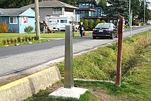
지계표(地界標), 바운더리 마커(boundary marker), 경계 표지, 경계 마커, 경계 표식은 토지경계의 시작이나 경계의 변화, 특히 경계방향의 변화를 식별하는 견고한 물리적 표식이다. 경계 나무, 기둥, 기념물, 오벨리스크 및 모서리로 알려진 여러 다른 유형의 명명된 경계 표시가 있다. 지계표는 경계를 결정하기 위해 경계선이 직선으로 이어지는 표식일 수도 있다. 지계표는 고정된 표식일 수도 있다.[1]
같이 보기
[편집]각주
[편집]- ↑ Porter, John (June 1990). 《AN HISTORICAL PERSPECTIVE – Longitude 129 degrees east, and why it is not the longest, straight line in the world》. National Perspectives – 32nd Australian Surveyors Congress Technical Papers 31 March – 6 April 1990. Canberra: The Institution: Eyepiece – Official Organ of The Institution of Surveyors, Australia, W.A. Division. 18–24쪽.
