
파일:Snow-cholera-map.jpg

미리 보기 크기: 613 × 599 픽셀 다른 해상도: 246 × 240 픽셀 | 491 × 480 픽셀 | 889 × 869 픽셀
원본 파일 (889 × 869 픽셀, 파일 크기: 248 KB, MIME 종류: image/jpeg)
파일 설명
| 묘사 |
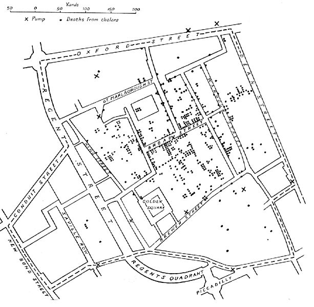
English: A variant of the original map drawn by Dr. John Snow (1813-1858), a British physician who is one of the founders of medical epidemiology, showing cases of cholera in the London epidemics of 1854, clustered around the locations of water pumps.
Español: Mapa original dibujado por el Dr. John Snow (1813-1858), médico inglés precursor de la epidemiología, que muestra los casos de cólera en la epidemia ocurrida en Londres en 1854. Los puntos muestran la localización de las personas afectadas por beber agua de los pozos (cruces)
Português: Mapa original elaborado pelo Dr. John Snow (1813-1858), médico britânico, um dos precursores da epidemiologia. O mapa mostra casos de cólera numa epidemia ocorrida em Londres em 1854. Os pontos indicam a localização de pessoas afetadas pela cólera por consumir água de poços, indicados pelas cruzes.
Nederlands: De originele kaart gemaakt door Dr. John Snow (1813-1858), een Engelse arts en een van de grondleggers van de medische epidemiologie, laat zien waar gevallen van cholera plaatsvonden tijdens de Londense epidemie van 1854, in relatie tot de waterpompen (kruisjes).
Deutsch: Variante einer im Original von Dr. John Snow (1813–1858) gezeichneten Karte. Der britische Arzt war ein Pionier der epidemiologischen Erforschung der Cholera. Die Karte zeigt Cholerafälle bei der Epidemie in London 1854, die sich bei einer Wasserpumpe (an der Broad Street) häufen. |
|||||||||
| 출처 |
미상 en.wikipedia에서 공용으로 옮겨왔습니다. |
|||||||||
| 창작자 |
after John Snow |
|||||||||
| 지리 정보 | ||||||||||
| 영역 상자 |
|
|||||||||
| 지리 참고 | ||||||||||
| 다른 버전 | File:Snow-cholera-map-1.jpg, the original | |||||||||
라이선스
|
이 작품은 미국, 그리고 저작권 보호 기간이 저작자 사후 70년, 또는 그 이하인 모든 국가에서 퍼블릭 도메인입니다.
| |
| 이 저작물은 모든 저작인접권을 포함한 저작권법하의 규제로부터 자유로운 것으로 확인되었습니다. | |
파일 역사
날짜/시간 링크를 클릭하면 해당 시간의 파일을 볼 수 있습니다.
| 날짜/시간 | 섬네일 | 크기 | 사용자 | 설명 | |
|---|---|---|---|---|---|
| 현재 | 2005년 11월 6일 (일) 20:10 | | 889 × 869 (248 KB) | Corso | *{{english}}The original map drawn by Dr. John Snow (1813-1858), a British physician who is one of the founders of medical epidemiology, showing cases of cholera in the London epidemics of 1854, clustered around the locations of water pumps. *{{spanish}} |
이 파일을 사용하는 문서
이 파일을 사용하는 문서가 없습니다.
이 파일을 사용하고 있는 모든 위키의 문서 목록
다음 위키에서 이 파일을 사용하고 있습니다:
- ast.wikipedia.org에서 이 파일을 사용하고 있는 문서 목록
- bg.wikipedia.org에서 이 파일을 사용하고 있는 문서 목록
- bn.wikipedia.org에서 이 파일을 사용하고 있는 문서 목록
- bs.wikipedia.org에서 이 파일을 사용하고 있는 문서 목록
- ca.wikipedia.org에서 이 파일을 사용하고 있는 문서 목록
- cs.wikipedia.org에서 이 파일을 사용하고 있는 문서 목록
- de.wikipedia.org에서 이 파일을 사용하고 있는 문서 목록
- en.wikipedia.org에서 이 파일을 사용하고 있는 문서 목록
- en.wikiversity.org에서 이 파일을 사용하고 있는 문서 목록
- eo.wikipedia.org에서 이 파일을 사용하고 있는 문서 목록
- es.wikipedia.org에서 이 파일을 사용하고 있는 문서 목록
- et.wikipedia.org에서 이 파일을 사용하고 있는 문서 목록
- eu.wikipedia.org에서 이 파일을 사용하고 있는 문서 목록
- ext.wikipedia.org에서 이 파일을 사용하고 있는 문서 목록
- fi.wikipedia.org에서 이 파일을 사용하고 있는 문서 목록
- fr.wikipedia.org에서 이 파일을 사용하고 있는 문서 목록
- hi.wikipedia.org에서 이 파일을 사용하고 있는 문서 목록
- hr.wikipedia.org에서 이 파일을 사용하고 있는 문서 목록
- hu.wikipedia.org에서 이 파일을 사용하고 있는 문서 목록
- io.wikipedia.org에서 이 파일을 사용하고 있는 문서 목록
- it.wikipedia.org에서 이 파일을 사용하고 있는 문서 목록
- ja.wikipedia.org에서 이 파일을 사용하고 있는 문서 목록
이 파일의 더 많은 사용 내역을 봅니다.