
파일:Extensió del valencià al País Valencià.svg

SVG 파일의 PNG 형식의 미리보기 크기: 424 × 600 픽셀. 다른 해상도: 170 × 240 픽셀 | 339 × 480 픽셀 | 543 × 768 픽셀 | 724 × 1,024 픽셀 | 1,448 × 2,048 픽셀 | 744 × 1,052 픽셀
원본 파일 (SVG 파일, 실제 크기 744 × 1,052 픽셀, 파일 크기: 962 KB)
파일 설명
| 묘사 |
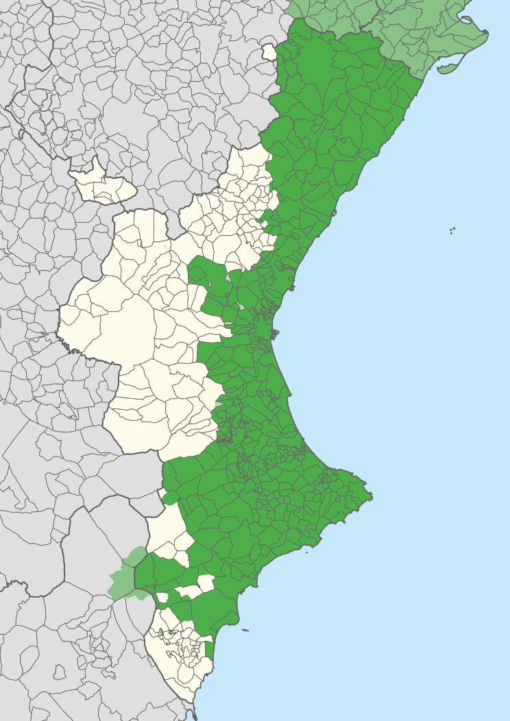
English: Extension of the Valencian language in the Valencian Community, according to Casanova and Sanchis Guarner.
Español: Extensión del Valenciano en la Comunidad Valenciana. |
| 지도 범례 |
Català:
Zones valencianoparlants a la Comunitat Valenciana. Zones valencianoparlants fora de la Comunitat Valenciana. Zones castellanoparlants a la Comunitat Valenciana que eren valencianoparlants el principi del s. XX. English:
Valencian-speaking regions in the Valencian Community. Valencian-speaking regions outside the Valencian Community. Spanish-speaking regions in the Valencian Community that were Valencian-speaking at the beginning of the 20th century. Español: Zonas Valencianoparlantes en la Comunidad Valenciana. Zones Valencianoparlantes fuera de la Comunidad Valenciana. Zonas Castellanoparlantes en la Comunidad Valenciana que eran Valencianoparlantes al principio del siglo XX. |
| 날짜 | |
| 출처 | Carche.map and OpenStreetMap. |
| 창작자 | |
| 지리 정보 | |
| 축척 | 1:1,500,000 |
| 표제 |
 |
| 지리 참고 | 부적절한 경우에 숨기려면 warp_status = skip로 설정하세요. |
| 다른 버전 |
이 파일은 다음으로 파생됨: |
| SVG 발전 | |
라이선스
| This work contains information from OpenStreetMap, which is made available under the Open Database License (ODbL).
The ODbL does not require any particular license for maps produced from ODbL data. Prior to 1 August 2020, map tiles produced by the OpenStreetMap Foundation were licensed under the CC-BY-SA-2.0 license. Maps produced by other people may be subject to other licences. |
이 파일은 크리에이티브 커먼즈 저작자표시-동일조건변경허락 2.5 일반 라이선스로 배포됩니다.
저작자표시: Joan M. Borràs (ebrenc)
- 이용자는 다음의 권리를 갖습니다:
- 공유 및 이용 – 저작물의 복제, 배포, 전시, 공연 및 공중송신
- 재창작 – 저작물의 개작, 수정, 2차적저작물 창작
- 다음과 같은 조건을 따라야 합니다:
- 저작자표시 – 적절한 저작자 표시를 제공하고, 라이센스에 대한 링크를 제공하고, 변경사항이 있는지를 표시해야 합니다. 당신은 합리적인 방식으로 표시할 수 있지만, 어떤 방식으로든 사용권 허가자가 당신 또는 당신의 사용을 지지하는 방식으로 표시할 수 없습니다.
- 동일조건변경허락 – 만약 당신이 이 저작물을 리믹스 또는 변형하거나 이 저작물을 기반으로 제작하는 경우, 당신은 당신의 기여물을 원저작물과 동일하거나 호환 가능한 라이선스에 따라 배포하여야 합니다.
파일 역사
날짜/시간 링크를 클릭하면 해당 시간의 파일을 볼 수 있습니다.
| 날짜/시간 | 섬네일 | 크기 | 사용자 | 설명 | |
|---|---|---|---|---|---|
| 현재 | 2020년 4월 21일 (화) 20:27 | | 744 × 1,052 (962 KB) | FogueraC | voltants |
| 2020년 4월 21일 (화) 01:24 |  | 744 × 1,052 (881 KB) | FogueraC | standard colors | |
| 2007년 5월 18일 (금) 10:12 |  | 725 × 1,244 (1.53 MB) | Ebrenc | {{Cc-by-sa-2.5|Joan M. Borràs (ebrenc)}} Category:Maps of the Land of Valencia Category:Catalan language |
이 파일을 사용하는 문서
이 파일을 사용하는 문서가 없습니다.
이 파일을 사용하고 있는 모든 위키의 문서 목록
다음 위키에서 이 파일을 사용하고 있습니다:
- ar.wikipedia.org에서 이 파일을 사용하고 있는 문서 목록
- ast.wikipedia.org에서 이 파일을 사용하고 있는 문서 목록
- ca.wikipedia.org에서 이 파일을 사용하고 있는 문서 목록
- co.wikipedia.org에서 이 파일을 사용하고 있는 문서 목록
- cs.wikipedia.org에서 이 파일을 사용하고 있는 문서 목록
- de.wikipedia.org에서 이 파일을 사용하고 있는 문서 목록
- en.wikipedia.org에서 이 파일을 사용하고 있는 문서 목록
- es.wikipedia.org에서 이 파일을 사용하고 있는 문서 목록
- Comunidad Valenciana
- Discusión:Idiomas de España
- Vega Baja del Segura
- Predominio lingüístico
- Ley de uso y enseñanza del valenciano
- Portal:Comunidad Valenciana
- Idioma valenciano
- Usuario:Castellónenred/Página de Pruebas/PortalCV/Cultura y Tradiciones
- Portal:Comunidad Valenciana/Cultura y Tradiciones
- Cultura de la Comunidad Valenciana
- Usuario:MetroVal/Valenciano
- Usuario:JuananMJ/Taller
- es.wikivoyage.org에서 이 파일을 사용하고 있는 문서 목록
- eu.wikipedia.org에서 이 파일을 사용하고 있는 문서 목록
- ext.wikipedia.org에서 이 파일을 사용하고 있는 문서 목록
- fi.wikipedia.org에서 이 파일을 사용하고 있는 문서 목록
- fr.wikipedia.org에서 이 파일을 사용하고 있는 문서 목록
- gl.wikipedia.org에서 이 파일을 사용하고 있는 문서 목록
- he.wikipedia.org에서 이 파일을 사용하고 있는 문서 목록
- ia.wikipedia.org에서 이 파일을 사용하고 있는 문서 목록
- id.wikipedia.org에서 이 파일을 사용하고 있는 문서 목록
- ie.wikipedia.org에서 이 파일을 사용하고 있는 문서 목록
- it.wikipedia.org에서 이 파일을 사용하고 있는 문서 목록
- ja.wikipedia.org에서 이 파일을 사용하고 있는 문서 목록
이 파일의 더 많은 사용 내역을 봅니다.