
파일:ETH-BIB-Internationaler Mathematikerkongress, Zürich 1932-Portrait-Portr 10680-FL.tif

TIF 파일의 JPG 형식의 미리보기 크기: 800 × 542 픽셀. 다른 해상도: 320 × 217 픽셀 | 640 × 433 픽셀 | 1,024 × 694 픽셀 | 1,280 × 867 픽셀 | 2,560 × 1,734 픽셀 | 4,530 × 3,068 픽셀
원본 파일 (4,530 × 3,068 픽셀, 파일 크기: 39.89 MB, MIME 종류: image/tiff)
파일 설명
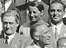
| Internationaler Mathematikerkongress, Zürich 1932
( |
|||||||||||||||||||||||||||
|---|---|---|---|---|---|---|---|---|---|---|---|---|---|---|---|---|---|---|---|---|---|---|---|---|---|---|---|
| 사진가 |
|
||||||||||||||||||||||||||
| 제목 |
Internationaler Mathematikerkongress, Zürich 1932 |
||||||||||||||||||||||||||
| 묘사된 장소 |
Deutsch: Universität Zürich, Westeingang English: University of Zurich, west entrance Français : Université de Zurich, entrée ouest |
||||||||||||||||||||||||||
| 날짜 | 촬영 날짜: 1932년 9월 7일, 14:30 | ||||||||||||||||||||||||||
| 기법 | black and white photograph on paper | ||||||||||||||||||||||||||
| 크기 | Spezialmass | ||||||||||||||||||||||||||
| 소장처 |
|
||||||||||||||||||||||||||
| 일련 번호 |
ETH-Bibliothek_Portr_10680-FL |
||||||||||||||||||||||||||
| 새겨진 글 |
top-left corner: Internationaler Mathematiker Kongress.
top-right corner: Zürich 1932.
|
||||||||||||||||||||||||||
| 각주 | Verhandlungen des Internationalen Mathematiker-Kongresses Zürich 1932, Band I: S. 10 (Programm: 14 Uhr 30: Es wurde eine photographische Gesamt-Aufnahme der Kongress-Teilnehmer beim Eingang der Universität gemacht), S. 13-26 (Delegiertenliste), S. 27-36 (Teilnehmerliste), S. 36 (Verteilung der Kongressmitglieder auf die Staaten: 667 Teilnehmer, 186 Begleiter) | ||||||||||||||||||||||||||
| 출처 |
E-Pics Bildarchiv online http://doi.org/10.3932/ethz-a-000099438
|
||||||||||||||||||||||||||
| 저작권 (이 파일을 인용하기) |
|
||||||||||||||||||||||||||
| 다른 버전 |
|
||||||||||||||||||||||||||


.jpg)

.jpg)
| 대상 위치 | | 이 지역의 다른 사진을 보기: OpenStreetMap |
|---|
| 카메라 위치 | | 이 지역의 다른 사진을 보기: OpenStreetMap |
|---|
Extracted images


파일 역사
날짜/시간 링크를 클릭하면 해당 시간의 파일을 볼 수 있습니다.
| 날짜/시간 | 섬네일 | 크기 | 사용자 | 설명 | |
|---|---|---|---|---|---|
| 현재 | 2017년 5월 31일 (수) 00:20 |  | 4,530 × 3,068 (39.89 MB) | ETH-Bibliothek | GWToolset: Erstelle Mediendatei für ETH-Bibliothek. |
이 파일을 사용하는 문서
이 파일을 사용하는 문서가 없습니다.
이 파일을 사용하고 있는 모든 위키의 문서 목록
다음 위키에서 이 파일을 사용하고 있습니다:
- eu.wikipedia.org에서 이 파일을 사용하고 있는 문서 목록
- fr.wikipedia.org에서 이 파일을 사용하고 있는 문서 목록