
파일:USGS magnitude 8 earthquakes since 1900.svg

SVG 파일의 PNG 형식의 미리보기 크기: 512 × 512 픽셀. 다른 해상도: 240 × 240 픽셀 | 480 × 480 픽셀 | 768 × 768 픽셀 | 1,024 × 1,024 픽셀 | 2,048 × 2,048 픽셀
원본 파일 (SVG 파일, 실제 크기 512 × 512 픽셀, 파일 크기: 112 KB)
파일 설명
| 설명 |
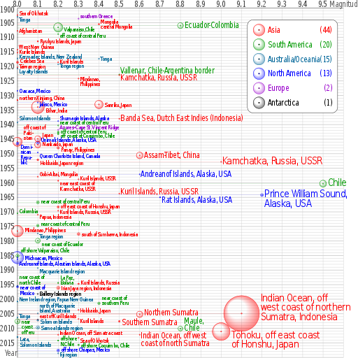
English: Earthquakes of moment magnitude 8.0 and greater from 1900 to 2018. The apparent 3D volumes of the bubbles are linearly proportional to their respective fatalities, i.e. their radii are linearly proportional to the cube root of the fatalities. Data is from https://earthquake.usgs.gov/earthquakes/eqarchives/year/mag8/magnitude8_1900_date.php ; The colour indicates the continent, and the legend counts the number of quakes for each. Notice the absence of Africa and the low presence of Antarctica and Europe. |
| 출처 | 자작 |
| 저자 | Cmglee |
| SVG 발전 | |
| 소스 코드 | PERL codetest
Perl script to create above; please do not remove.
#!/usr/bin/perl
$data_string = qq`
as|1902/06/11 05:|50.00|148.00|8.0||Sea of Okhotsk|-8
oc|1903/01/04 05:07|-20.00|-175.00|8.0||Tonga|8
eu|1903/08/11 04:32|36.36|22.97|8.3||southern Greece|-10
as|1905/07/09 09:40|49.0|99.0|8.4||Mongolia|-10
as|1905/07/23 02:46|49.0|98.0|8.4||central Mongolia|8
sa|1906/01/31 15:36|1.0|-81.5|8.8|1000|Colombia-Ecuador||Ecuador-Colombia
sa|1906/08/17 00:40|-33.0|-72.0|8.2|3882|Valparaiso, Chile|5|Valparaiso,Chile
as|1907/10/21 04:23|38.00|69.00|8.0||Afghanistan
sa|1908/12/12 12:08|-14.0|-78.0|8.2||off the coast of central Peru|5|off coast of central Peru
as|1911/06/15 14:26|28.0|130.0|8.1|12|Ryukyu Islands, Japan
as|1914/05/26 14:22|-2.|137.|8.0||West New Guinea|-10
as|1915/05/01 05:00|47.|155.|8.0||Kurile Islands|-4
oc|1917/05/01 18:26|-29.0|-177.0|8.0||Kermadec Islands, New Zealand|-8
oc|1917/06/26 05:49|-15.0|-173.0|8.4||Tonga
as|1918/08/15 12:18|5.653|123.563|8.0|50|Celebes Sea|-5
as|1918/09/07 17:16|45.5|151.5|8.2||Kuril Islands|-4
oc|1919/04/30 07:17|-19.823|-172.215|8.2||Tonga region|5
as|1920/06/05 04:21|23.5|122.0|8.0||Taiwan region|-5
oc|1920/09/20 14:39|-20.0|168.0|8.0||Loyalty Islands|10
sa|1922/11/11 04:32|-28.553|-70.755|8.5||Chile-Argentina Border|-12|Vallenar, Chile-Argentina border
as|1923/02/03 16:01|54.0|161.0|8.5||Kamchatka|10|Kamchatka, Russia, USSR
as|1924/04/14 16:20|7.023|125.954|8.3||Mindanao, Philippines||Mindanao,~Philippines
na|1928/06/17 03:19|16.33|-96.7|8.0||Oaxaca, Mexico
as|1931/08/10 21:18|47.1|89.8|8.0|5|northern Xinjiang, China|-8
na|1932/06/03 10:36|19.84|-103.99|8.1||Jalisco, Mexico|5
as|1933/03/02 17:31|39.22|144.62|8.4|2990|Sanriku, Japan
as|1934/01/15 08:43|27.55|87.09|8.1|10700|Bihar, India|10
as|1938/02/01 19:04|-5.05|131.62|8.5||Banda Sea||Banda Sea, Dutch East Indies (Indonesia)
na|1938/11/10 20:18|55.33|-158.37|8.2||Shumagin Islands, Alaska|-12
oc|1939/04/30 02:55|-10.5|158.5|8.0||Solomon Islands|-15
sa|1940/05/24 16:33|-10.5|-77.0|8.2||near the Coast of central Peru|-12|near coast of central Peru
eu|1941/11/25 18:03|37.171|-18.960|8.2||Azores-Cape St. Vincent Ridge|-10
sa|1942/08/24 22:50|-15.0|-76.0|8.2|30|Off the coast of central Peru|-3|off coast of central Peru
sa|1943/04/06 16:07|-30.75|-72.0|8.2|18|off the coast of Coquimbo, Chile|5|off coast of Coquimbo, Chile
as|1944/12/07 04:35|33.75|136.00|8.1|1223|Tonankai, Japan|-15|Japan
as|1945/11/27 21:57|24.5|63.0|8.0|4000|off the coast of Pakistan|-50|off coast of~Paki-~stan
na|1946/04/01 12:28|52.75|-163.50|8.1|165|Unimak Islands, Alaska|-10|Unimak Islands, Alaska, USA
na|1946/08/04 17:51|19.25|-69.00|8.0|100|Dominican Republic|10|Domi-~nican~Repu-~blic
as|1946/12/20 19:19|32.5|134.5|8.1|1330|Nankaido, Japan|-2
as|1948/01/24 17:46|10.5|122.0|8.2|72|Panay, Philippines|5
na|1949/08/22 04:01|53.62|-133.27|8.1||Queen Charlotte Island, B.C., Canada|10|Queen Charlotte Island, Canada
as|1950/08/15 14:09|28.5|96.5|8.6|1526|Assam-Tibet||Assam-Tibet, China
as|1952/03/04 01:22|42.5|143.0|8.1|31|Hokkaido, Japan region|10
as|1952/11/04 16:58|52.76|160.06|9.0||Kamchatka, Russia||Kamchatka, Russia, USSR
na|1957/03/09 14:22|51.56|-175.39|8.6||Andreanof Islands, Alaska||Andreanof Islands, Alaska, USA
as|1957/12/04 03:37|45.15|99.21|8.1||Gobi-Altai, Mongolia|-10
as|1958/11/06 22:58|44.329|148.623|8.3||Kuril Islands|-3|Kuril Islands, USSR
as|1959/05/04 07:15|53.351|159.645|8.2|1|near the east coast of Kamchatka|8|near east coast of~Kamchatka, USSR
sa|1960/05/22 19:11|-38.29|-73.05|9.5|1655|Chile
as|1963/10/13 05:17|44.9|149.6|8.5||Kuril Islands|-5|Kuril Islands, Russia, USSR
na|1964/03/28 03:36|61.02|-147.65|9.2|125|Prince William Sound, Alaska||Prince William Sound,~Alaska, USA
na|1965/02/04 05:01|51.21|-178.50|8.7|5|Rat Islands, Alaska|10|Rat Islands, Alaska, USA
sa|1966/10/17 21:41|-10.807|-78.684|8.1|125|near the coast of central Peru|-5|near coast of central Peru
as|1968/05/16 00:49|40.903|143.346|8.2|47|off the east coast of Honshu, Japan|-4|off east coast of Honshu, Japan
as|1969/08/11 21:27|43.478|147.815|8.2||Kuril Islands|2|Kuril Islands, Russia, USSR
sa|1970/07/31 17:08|-1.49|-72.56|8.0||Colombia|-8
as|1971/01/10 07:17|-3.132|139.697|8.1||Papua, Indonesia|5
sa|1974/10/03 14:21|-12.254|-77.524|8.1|78|near the coast of central Peru|-7|near coast of central Peru
as|1976/08/16 16:11|6.292|124.090|8.0|8000|Mindanao, Philippines|-5
oc|1977/06/22 12:08|-22.878|-175.900|8.1||Tonga region|8
as|1977/08/19 06:08|-11.085|118.464|8.3|100|south of Sumbawa, Indonesia
sa|1979/12/12 07:59|1.598|-79.358|8.1|600|near the coast of Ecuador|10|near coast of Ecuador
sa|1985/03/03 22:47|-33.135|-71.871|8.0|177|offshore Valparaiso, Chile|-20
na|1985/09/19 13:17|18.190|-102.533|8.0|9500|Michoacan, Mexico
na|1986/05/07 22:47|51.520|-174.776|8.0||Andreanof Islands, Aleutian Islands, Alaska|15|Andreanof Islands, Aleutian Islands, Alaska, USA
oc|1989/05/23 10:54|-52.341|160.568|8.1||Macquarie Island region|10
sa|1994/06/09 00:33|-13.841|-67.553|8.2|5|La Paz, Bolivia|-20|La Paz,~Bolivia
as|1994/10/04 13:22|43.773|147.321|8.3|11|Kuril Islands|-5|Kuril Islands, Russia
sa|1995/07/30 05:11|-23.340|-70.294|8.0|3|Near Coast of Northern Chile|-32|near coast of~north Chile
na|1995/10/09 15:35|19.055|-104.205|8.0|49|Near Coast of Jalisco, Mexico|2|near coast of~Mexico
as|1996/02/17 05:59|-0.891|136.952|8.2|166|Irian Jaya region, Indonesia
an|1998/03/25 03:12|-62.877|149.527|8.1||Balleny Islands region|-2
oc|2000/11/16 04:54|-3.980|152.169|8.0|2|New Ireland region, Papua New Guinea|-8
sa|2001/06/23 20:33|-16.264|-73.641|8.4|75|near the coast of southern Peru|-20|near coast of~southern Peru
as|2003/09/25 19:50|41.815|143.910|8.3||Hokkaido, Japan region||Hokkaido, Japan
oc|2004/12/23 14:59|-49.312|161.345|8.1||north of Macquarie Island|-28|north of Macquarie~Island, Australia
as|2004/12/26 00:58|3.295|95.982|9.1|227898|off the west coast of northern Sumatra|-50|Indian Ocean, off~west coast of northern~Sumatra, Indonesia
as|2005/03/28 16:09|2.074|97.013|8.6|1313|Northern Sumatra, Indonesia|-5|Northern Sumatra
oc|2006/05/03 15:26|-20.187|-174.123|8.0||Tonga|-5
as|2006/11/15 11:14|46.592|153.226|8.3||Kuril Islands|5
as|2007/01/13 04:23:21|46.243|154.524|8.1||East of the Kuril Islands|-13|east of Kuril Islands
oc|2007/04/01 20:39:58|-8.466|157.043|8.1|34|Solomon Islands|5
sa|2007/08/15 23:40:57|-13.386|-76.603|8.0|650|Near the Coast of Central Peru||near~coast~of Peru
as|2007/09/12 11:10:26|-4.438|101.367|8.5|25|Southern Sumatra, Indonesia|5|Southern Sumatra
oc|2009/09/29 17:48:10|-15.489|-172.095|8.1|192|Samoa Islands region|0
sa|2010/02/27 06:34:14|-35.846|-72.719|8.8|577|Offshore Maule, Chile|-25|Maule,~Chile
as|2011/03/11 05:46:23|38.322|142.369|9.0|28050|Near the East Coast of Honshu, Japan|15|Tōhoku, off east coast~of Honshu, Japan
as|2012/04/11 08:38:37|2.311|93.063|8.6||off the west coast of northern Sumatra|5|Indian Ocean, off west~coast of north Sumatra
as|2012/04/11 10:43:09|0.773|92.452|8.2||off the west coast of northern Sumatra|-7|Indian Ocean, off Sumatra coast
oc|2013/02/06 01:12:27|-10.738|165.138|8.0|13|Lata,~Solomon Islands|7|
as|2013/05/24 06:44:49|54.874|153.281|8.3||Sea of Okhotsk|7|
sa|2014/04/01 23:46:47|-19.642|-70.817|8.2|6|offshore~N.Chile|-7|
sa|2015/09/16 22:54|-31.570|-71.654|8.3|14|offshore Coquimbo, Chile
na|2017/09/08 04:49|15.022|-93.899|8.2|98|offshore Chiapas, Mexico|-3
oc|2018/08/19 00:19|-18.178|-178.111|8.2|0|Fiji region|4
`;
%continents = (
"na" => { "colour" => "#0000ff", "count" => 0, "name" => "North America" },
"sa" => { "colour" => "#009900", "count" => 0, "name" => "South America" },
"eu" => { "colour" => "#9900cc", "count" => 0, "name" => "Europe" },
"af" => { "colour" => "#996600", "count" => 0, "name" => "Africa" },
"as" => { "colour" => "#ff0000", "count" => 0, "name" => "Asia" },
"oc" => { "colour" => "#006699", "count" => 0, "name" => "Australia/Oceania" },
"an" => { "colour" => "#000000", "count" => 0, "name" => "Antarctica" },
undef);
@continent_order = ("as", "sa", "oc", "na", "eu", "an", "af");
# @continent_order = ("na","sa", "eu", "af", "as", "oc", "an");
$mag_min = 8; $mag_max = 9.6; $date_min = 1900; $date_max = 2020;
$x_min = 0; $x_max = &x($mag_max); $y_min = 0; $y_max = &y($date_max);
$x_legend = 790; $y_legend = 40; $w_legend = 310; $h_legend = 320;
$x_viewbox = -60; $y_viewbox = -28; $width_viewbox = 1230; $height_viewbox = 1230;
$out_graph = $out_legend = $out_grid = $out_grad = "";
$x_margin = &x($mag_min);
sub year_fraction {
($y, $m, $d) = split(/\//, $_[0]);
# $y = $_[0];
# $m = $_[1] || 1;
# $d = $_[2] || 1;
$is_leap_year = $y % 100 ? ($y % 4 == 0) : ($y % 400 == 0);
$day_of_year = int($d - ($m < 3 ? 30 : $is_leap_year ? 31 : 32) + 30.56 * $m);
return $y + ($day_of_year - 1) / ($is_leap_year ? 366 : 365);
}
sub x { return sprintf("%.3f", 700 * ($_[0] - $mag_min)); }
sub y { return sprintf("%d", 10 * ($_[0] - $date_min)); }
$double_dash = "-" . "-";
$file_out = $0; $file_out =~ s/[^\.]*$/svg/;
@data = split(/\n/, $data_string);
foreach (@data) {
if ($_ && substr($_, 0, 1) ne "#") {
($continent, $datetime, $latitude, $longitude, $magnitude, $fatalities, $region, $label_offset, $label) = split(/\|/, $_);
if ($magnitude >= $mag_min) {
print "$continent\t$datetime\t$latitude\t$longitude\t$magnitude\t$fatalities\t$region\t$label_offset\t$label\n";
($date, $time) = split(/\s/, $datetime);
$x = &x($magnitude);
$y = &y(&year_fraction($date));
$r = $fatalities ** (1 / 3);
$x_label = $x + $r + 4;
$y_label = $y + $label_offset + 8;
$colour = $continents{$continent}{"colour"};
++$continents{$continent}{"count"};
if ($label eq "") { $label = $region; }
if ($label =~ m/~/) {
$label =~ s`~`</tspan><tspan x="0" dy="0.9em">`g;
$label = qq`<tspan>${label}</tspan>`;
}
$font_size = $magnitude < 8.5 ? qq` font-size="20"` :
($magnitude >= 9 ? qq` font-size="36"` : qq``);
$out_graph .= qq`
<g stroke="${colour}" fill="${colour}">
<text transform="translate(${x_label},${y_label}) scale(0.8,1)" x="0" y="0"${font_size} stroke="none">${label}</text>
<circle cx="${x}" cy="${y}" r="${r}" fill="url(#grad_${continent})"/>
<circle cx="${x}" cy="${y}" r="2" fill-opacity="0.5"/>
<path d="M ${x} ${y} H ${x_margin}" stroke-width="0.5" stroke-opacity="0.5"/>
</g>`;
}
}
}
$y = 35;
foreach (@continent_order) {
$count = $continents{$_}{"count"};
if ($count > 0) {
$colour = $continents{$_}{"colour"};
$name = $continents{$_}{"name"};
$out_grad .= qq`
<radialGradient id="grad_${_}" cx="50%" cy="50%" r="50%" fx="25%" fy="25%">
<stop offset="50%" stop-color="${colour}" stop-opacity="0"/>
<stop offset="100%" stop-color="${colour}" stop-opacity="0.5"/>
</radialGradient>`;
$out_legend .= qq`
<text transform="translate(70,${y}) scale(0.8,1)" x="0" y="10" fill="${colour}"><tspan>${name}</tspan><tspan x="280" text-anchor="end">(${count})</tspan></text>
<circle cx="40" cy="${y}" r="20" stroke="${colour}" fill="url(#grad_${_})"/>
<circle cx="40" cy="${y}" r="2" stroke="${colour}"/>`;
$y += 50;
}
}
for ($mag = $mag_max; $mag >= $mag_min; $mag -= 0.1) {
$x = &x($mag);
$mag = sprintf("%0.1f", $mag);
$out_grid .= qq`
<use xlink:href="#grid_x" transform="translate(${x},0)"/>`;
if ($mag < $mag_max) {
$out_grid .= qq`
<text transform="translate(${x},-5) scale(0.8,1)" x="0" y="0" text-anchor="middle">${mag}</text>`;
}
}
for ($date = $date_max; $date >= $date_min; $date -= 5) {
$y = &y($date);
if ($date > $date_min) {
$out_grid .= qq`
<use xlink:href="#grid_y_5" transform="translate(0,${y})"/>`;
if ($date < $date_max) {
$out_grid .= qq`
<text transform="translate(-5,${y}) scale(0.8,1)" x="0" y="10" text-anchor="end">${date}</text>`;
}
} else {
$out_grid .= qq`
<text transform="translate(-5,${y}) scale(0.8,1)" x="0" y="15" text-anchor="end">${date}</text>`;
}
}
open (FILE_OUT, ">$file_out");
print FILE_OUT qq`<?xml version="1.0" encoding="utf-8"?>
<svg xmlns="http://www.w3.org/2000/svg" xmlns:xlink="http://www.w3.org/1999/xlink" width="100%" height="100%" viewBox="${x_viewbox} ${y_viewbox} ${width_viewbox} ${height_viewbox}">
<title>Magnitude 8.0 and greater earthquakes since 1900</title>
<desc>Earthquakes of moment magnitude 8.0 and greater since 1900, charted by CMG Lee. The apparent 3D volumes of the bubbles are linearly proportional to their respective fatalities, i.e. their radii are linearly proportional to the cube root of the fatalities. Data is from https://earthquake.usgs.gov/earthquakes/eqarchives/year/mag8/magnitude8_1900_date.php , http://comcat.cr.usgs.gov/earthquakes/eventpage/usc000f1s0 and http://comcat.cr.usgs.gov/earthquakes/eventpage/usb000h4jh .</desc>
<defs>${out_grad}
<path id="grid_x" d="M 0 ${y_min} V ${y_max}"/>
<path id="grid_y" d="M ${x_min} 0 h -1 H ${x_max}"/>
<path id="grid_y_tick" d="M ${x_min} 0 h -2 H ${x_max}" stroke-width="2"/>
<g id="grid_y_5">
<use xlink:href="#grid_y_tick"/>
<use xlink:href="#grid_y" transform="translate(0,-10)"/>
<use xlink:href="#grid_y" transform="translate(0,-20)"/>
<use xlink:href="#grid_y" transform="translate(0,-30)"/>
<use xlink:href="#grid_y" transform="translate(0,-40)"/>
</g>
</defs>
<rect x="${x_viewbox}" y="${y_viewbox}" width="${width_viewbox}" height="${height_viewbox}" fill="#ffffff"/>
<g font-family="sans-serif" letter-spacing="-2" font-size="28" text-anchor="start">
<g stroke="#cccccc" fill="#000000">${out_grid}
<path d="M 0 ${y_max} V 0 H ${x_max}" stroke="#000000" fill="none"/>
</g>
<g transform="scale(0.8,1)" fill="#666666">
<text x="-55" y="1195">Year</text>
<text x="1340" y="-5">Magnitude</text>
</g>
<g transform="translate(${x_legend},${y_legend})">
<rect x="0" y="0" width="${w_legend}" height="${h_legend}" rx="20" ry="20" stroke="#000000" fill="#ffffff"/>${out_legend}
</g>
${out_graph}
</g>
</svg>
<!${double_dash} Perl script to create above; please do not remove.
`;
open (FILE_IN, $0);
while (<FILE_IN>) { print FILE_OUT $_; }
close FILE_IN;
print FILE_OUT "# ${double_dash}>";
close FILE_OUT;
#
|
라이선스
나는 아래 작품의 저작권자로서, 이 저작물을 다음과 같은 라이선스로 배포합니다:
이 파일은 크리에이티브 커먼즈 저작자표시-동일조건변경허락 3.0 Unported 라이선스로 배포됩니다.
- 이용자는 다음의 권리를 갖습니다:
- 공유 및 이용 – 저작물의 복제, 배포, 전시, 공연 및 공중송신
- 재창작 – 저작물의 개작, 수정, 2차적저작물 창작
- 다음과 같은 조건을 따라야 합니다:
- 저작자표시 – 적절한 저작자 표시를 제공하고, 라이센스에 대한 링크를 제공하고, 변경사항이 있는지를 표시해야 합니다. 당신은 합리적인 방식으로 표시할 수 있지만, 어떤 방식으로든 사용권 허가자가 당신 또는 당신의 사용을 지지하는 방식으로 표시할 수 없습니다.
- 동일조건변경허락 – 만약 당신이 이 저작물을 리믹스 또는 변형하거나 이 저작물을 기반으로 제작하는 경우, 당신은 당신의 기여물을 원저작물과 동일하거나 호환 가능한 라이선스에 따라 배포하여야 합니다.

|
GNU 자유 문서 사용 허가서 1.2판 또는 자유 소프트웨어 재단에서 발행한 이후 판의 규정에 따라 본 문서를 복제하거나 개작 및 배포할 수 있습니다. 본 문서에는 변경 불가 부분이 없으며, 앞 표지 구절과 뒷 표지 구절도 없습니다. 본 사용 허가서의 전체 내용은 GNU 자유 문서 사용 허가서 부분에 포함되어 있습니다. |
이 라이선스 중에서 목적에 맞는 것을 선택하여 사용할 수 있습니다.
파일 역사
날짜/시간 링크를 클릭하면 해당 시간의 파일을 볼 수 있습니다.
| 날짜/시간 | 섬네일 | 크기 | 사용자 | 설명 | |
|---|---|---|---|---|---|
| 현재 | 2018년 10월 7일 (일) 16:53 | | 512 × 512 (112 KB) | JoKalliauer | Inkscape: --verb=SelectionUnGroup (inkscape --verb=EditSelectAll --verb=SelectionUnGroup --verb=SelectionUnGroup --verb=SelectionUnGroup --verb=SelectionUnGroup --verb=SelectionUnGroup --verb=FileSave --verb=FileClose ./${file}u.svg --verb=FileQuit) |
| 2018년 10월 7일 (일) 07:04 |  | 512 × 512 (40 KB) | JoKalliauer | try to simplify file | |
| 2018년 10월 6일 (토) 03:47 |  | 512 × 512 (61 KB) | Cmglee | Try to fix bubbles. | |
| 2018년 10월 5일 (금) 03:18 |  | 512 × 512 (61 KB) | Cmglee | Update up to 2018-10-04. | |
| 2015년 4월 3일 (금) 08:21 |  | 512 × 512 (60 KB) | Cmglee | Add 2014 quake, axis labels (w:user_talk:cmglee#Earthquake_graph) and minor cosmetic changes. | |
| 2013년 7월 3일 (수) 21:13 |  | 512 × 512 (60 KB) | Cmglee | Add 2013 quakes and minor cosmetic changes. | |
| 2012년 4월 14일 (토) 07:48 |  | 512 × 512 (59 KB) | Cmglee | Add counts to legend and refine more labels. | |
| 2012년 4월 14일 (토) 07:09 |  | 512 × 512 (59 KB) | Cmglee | Refine labels. | |
| 2012년 4월 14일 (토) 06:16 |  | 512 × 512 (58 KB) | Cmglee | Add magnitude 8.0 to 8.4 earthquakes to match filename. | |
| 2012년 4월 14일 (토) 04:24 |  | 512 × 512 (23 KB) | Cmglee | Shorten label to fit. |
이 파일을 사용하는 문서
다음 문서 1개가 이 파일을 사용하고 있습니다:
이 파일을 사용하고 있는 모든 위키의 문서 목록
다음 위키에서 이 파일을 사용하고 있습니다:
- am.wikipedia.org에서 이 파일을 사용하고 있는 문서 목록
- ar.wikipedia.org에서 이 파일을 사용하고 있는 문서 목록
- en.wikipedia.org에서 이 파일을 사용하고 있는 문서 목록
- fa.wikipedia.org에서 이 파일을 사용하고 있는 문서 목록
- gl.wikipedia.org에서 이 파일을 사용하고 있는 문서 목록
- hu.wikipedia.org에서 이 파일을 사용하고 있는 문서 목록
- id.wikipedia.org에서 이 파일을 사용하고 있는 문서 목록
- mnw.wikipedia.org에서 이 파일을 사용하고 있는 문서 목록
- ms.wikipedia.org에서 이 파일을 사용하고 있는 문서 목록
- pa.wikipedia.org에서 이 파일을 사용하고 있는 문서 목록
- pt.wikipedia.org에서 이 파일을 사용하고 있는 문서 목록
- tr.wikipedia.org에서 이 파일을 사용하고 있는 문서 목록
- uk.wikipedia.org에서 이 파일을 사용하고 있는 문서 목록
- zh.wikipedia.org에서 이 파일을 사용하고 있는 문서 목록