본문으로 이동

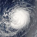
파일:Typhoon Mawar 2005.jpg

문서 내용이 다른 언어로는 지원되지 않습니다.
위키백과, 우리 모두의 백과사전.

원본 파일(4,200 × 4,200 픽셀, 파일 크기: 2.61 MB, MIME 종류: image/jpeg)

파일 설명

설명

Typhoon Mawar is posing photogenically in this satellite image. The storm was far out in the northwestern Pacific Ocean, some 900 kilometers from Tokyo. It was traveling in parallel with Tropical Cyclone Guchol, both headed roughly northwest at comparable speeds. Mawar, however, will strike mainland Japan on its projected course, and will have built to a Category 4 storm with sustained winds of over 320 kilometers per hour (200 miles per hour) as it strikes shore around August 25. Guchol, however, will never come close to shore if current projections are correct, and will remain a substantially weaker system with peak winds less than half the speed of Typhoon Mawar.

The Moderate Resolution Imaging Spectroradiometer (MODIS) on NASA’s Terra satellite captured this image at 10:10 a.m. local time, on August 22, 2005. At this time, Mawar had peak winds around 200 km/hr (125 mph). This image was cropped from a larger image depicting both Mawar and Guchol.
날짜
출처 http://visibleearth.nasa.gov/view_rec.php?id=7054
저자 Jeff Schmaltz, MODIS Rapid Response Team, NASA/GSFC
저작권
(이 파일을 인용하기)
Public domain 이 파일은 NASA에서 제작하였으므로 퍼블릭 도메인입니다. NASA의 저작권 정책에 따르면 NASA의 자료는 명시하지 않는 이상 저작권의 보호를 받지 않습니다. (Template:PD-USGov, 또는 NASA 저작권 정책 문서, JPL 그림 사용 정책을 참고하세요.)
주의사항:
다른 버전 Image:Mawar and Guchol 2005.jpg

설명

이 파일이 나타내는 바에 대한 한 줄 설명을 추가합니다

이 파일에 묘사된 항목

다음을 묘사함

파일 역사

날짜/시간 링크를 클릭하면 해당 시간의 파일을 볼 수 있습니다.

날짜/시간섬네일크기사용자설명
현재2006년 9월 7일 (목) 03:082006년 9월 7일 (목) 03:08 판의 섬네일4,200 × 4,200 (2.61 MB)Good kitty== Summary == {{Information |Description= Typhoon Mawar is posing photogenically in this satellite image. The storm was far out in the northwestern Pacific Ocean, some 900 kilometers from Tokyo. They are traveling in parallel with Tropical Cyclone Guchol,

이 파일을 사용하는 문서가 없습니다.

이 파일을 사용하고 있는 모든 위키의 문서 목록

다음 위키에서 이 파일을 사용하고 있습니다:

메타데이터