
파일:Tsushima Omega Tower 1977 2.jpg

미리 보기 크기: 799 × 600 픽셀 다른 해상도: 320 × 240 픽셀 | 640 × 480 픽셀 | 1,023 × 768 픽셀 | 1,107 × 831 픽셀
원본 파일 (1,107 × 831 픽셀, 파일 크기: 251 KB, MIME 종류: image/jpeg)
파일 설명
| 설명 |
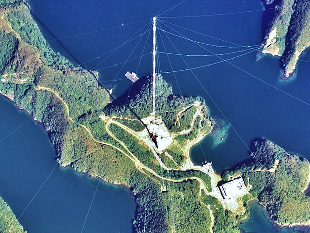
English: Shushi-Wan Omega Transmitter (station H) of the Omega navigation system, an obsolete worldwide navigation system, which transmitted in the VLF band on 10 - 14 kHz. The antenna, situated near Shushi-Wan on Tsushima Island was an umbrella antenna consisting of a 389-metre tall tubular steel mast, insulated against ground, with 14 wires extending diagonally from the top to the ground. This mast, which was built in 1973 and which was the tallest structure in Japan (and perhaps the tallest tubular steel mast ever built) was dismantled in 1998.
日本語: 対馬オメガ局。 |
|||
| 날짜 | ||||
| 출처 | Japan Ministry of Land, Infrastructure and Transport. [1] | |||
| 저자 | retouch: Qurren (talk). | |||
| 다른 버전 |
|
| 카메라 위치 | | 이 지역의 다른 사진을 보기: OpenStreetMap |
|---|
라이선스

|
이 파일의 저작권자인 일본 국토교통성은 저작권자를 명시하는 조건에 따라 누구에게나 어떤 목적으로든지 제한 없이 사용할 수 있도록 허용하였습니다. 재배포나 이차적 저작물 작성 및 상업적 이용 등이 허용됩니다. |
저작자표시:
Copyright © National Land Image Information (Color Aerial Photographs), Ministry of Land, Infrastructure, Transport and Tourism
|
 |
This image is copyrighted by the Ministry of Land, Infrastructure, Transport and Tourism of Japan. For terms of use, see the stipulation to use of National Land Information (in Japanese) and message from MLIT (in Japanese and English). When you display this image on an article, include the following phrase in the description: "Made based on National Land Image Information (Color Aerial Photographs), Ministry of Land, Infrastructure, Transport and Tourism".
|
파일 역사
날짜/시간 링크를 클릭하면 해당 시간의 파일을 볼 수 있습니다.
| 날짜/시간 | 섬네일 | 크기 | 사용자 | 설명 | |
|---|---|---|---|---|---|
| 현재 | 2013년 10월 6일 (일) 23:09 | | 1,107 × 831 (251 KB) | Qurren | == {{int:filedesc}} == {{Information |Description={{en|1=en:Tsushima Omega Tower.}} {{ja|1=ja:対馬オメガ局。}} |Source=Japan Ministry of Land, Infrastructure and Transport. [http://w3land.mlit.go.jp/cgi-bin/WebGIS2/WC_AirPhoto.cgi?IT... |
이 파일을 사용하는 문서
다음 문서 1개가 이 파일을 사용하고 있습니다:
이 파일을 사용하고 있는 모든 위키의 문서 목록
다음 위키에서 이 파일을 사용하고 있습니다:
- en.wikipedia.org에서 이 파일을 사용하고 있는 문서 목록
- fr.wikipedia.org에서 이 파일을 사용하고 있는 문서 목록
- ja.wikipedia.org에서 이 파일을 사용하고 있는 문서 목록
- uk.wikipedia.org에서 이 파일을 사용하고 있는 문서 목록
- www.wikidata.org에서 이 파일을 사용하고 있는 문서 목록