
파일:TrafficLights-HagerstownMD.jpg
최대 해상도입니다.
TrafficLights-HagerstownMD.jpg (800 × 531 픽셀, 파일 크기: 74 KB, MIME 종류: image/jpeg)
파일 설명
| 설명 |
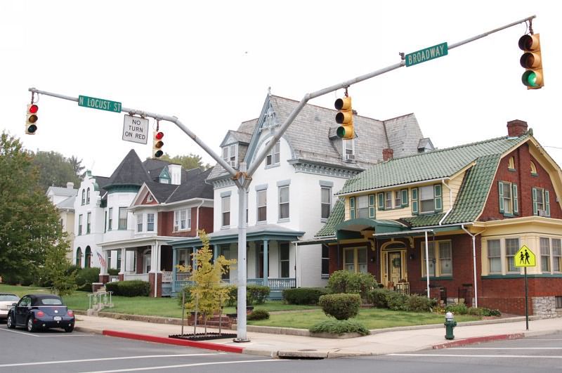
English: This picture shows a street corner on Broadway near downtown Hagerstown.
As typical for rural areas in the United States the lights are rather trivially mounted here on the opposite of the crossroads and extra signals for pedestrian crosswalks are completely missing. Deutsch: Verkehrsampel an einer Straßenkreuzung am Rande der Innenstadt von Hagerstown, Maryland. Die Ampel zeigt eine eher einfache Konstruktion, wie sie für US-amerikanische Verhältnisse durchaus typisch ist. Die Ampeln hängen an der gegenüberliegenden Seite der Kreuzung, und Fußgängerampeln fehlen ganz. |
| 날짜 | 2006년 10월 2일 (원본 올리기 일시) |
| 출처 | Transferred from en.wikipedia |
| 저자 | Original uploader was JoSePh at en.wikipedia |
| 저작권 (이 파일을 인용하기) |
Released into the public domain (by the author). |
| 카메라 위치 | | 이 지역의 다른 사진을 보기: OpenStreetMap |
|---|
라이선스
| |
이 작품은 위키미디어 공용의 JoSePh 사용자가 퍼블릭 도메인으로 공개한 작품입니다. 이 공개 선언은 전세계적으로 유효합니다. 만약 저작권의 포기가 법률적으로 가능하지 않은 경우, |
기존 올리기 기록
The original description page was here. All following user names refer to en.wikipedia.
- 2006-10-02 01:28 JoSePh 800×531×??? (76186 bytes) {{PD-release}}
파일 역사
날짜/시간 링크를 클릭하면 해당 시간의 파일을 볼 수 있습니다.
| 날짜/시간 | 섬네일 | 크기 | 사용자 | 설명 | |
|---|---|---|---|---|---|
| 현재 | 2008년 9월 10일 (수) 05:36 | | 800 × 531 (74 KB) | Johnny S. | {{Information |Description= {{en|This picture shows a street corner on Broadway near downtown Hagerstown.<br/>As typical for rural areas in the United States the lights are rather trivially mounted here on the opposite of the crossroads and extra signals |
이 파일을 사용하는 문서
다음 문서 1개가 이 파일을 사용하고 있습니다:
이 파일을 사용하고 있는 모든 위키의 문서 목록
다음 위키에서 이 파일을 사용하고 있습니다:
- ar.wikipedia.org에서 이 파일을 사용하고 있는 문서 목록
- cs.wikipedia.org에서 이 파일을 사용하고 있는 문서 목록
- en.wikipedia.org에서 이 파일을 사용하고 있는 문서 목록
- fa.wikipedia.org에서 이 파일을 사용하고 있는 문서 목록
- fi.wikipedia.org에서 이 파일을 사용하고 있는 문서 목록
- fr.wikipedia.org에서 이 파일을 사용하고 있는 문서 목록
- hr.wikipedia.org에서 이 파일을 사용하고 있는 문서 목록
- hu.wikipedia.org에서 이 파일을 사용하고 있는 문서 목록
- id.wikipedia.org에서 이 파일을 사용하고 있는 문서 목록
- incubator.wikimedia.org에서 이 파일을 사용하고 있는 문서 목록
- it.wikipedia.org에서 이 파일을 사용하고 있는 문서 목록
- no.wikipedia.org에서 이 파일을 사용하고 있는 문서 목록
- ta.wikipedia.org에서 이 파일을 사용하고 있는 문서 목록
- vi.wikipedia.org에서 이 파일을 사용하고 있는 문서 목록
- war.wikipedia.org에서 이 파일을 사용하고 있는 문서 목록