
파일:Tondo and Pasig 1450.png

원본 파일 (1,778 × 1,699 픽셀, 파일 크기: 90 KB, MIME 종류: image/png)
파일 설명
| 설명 |
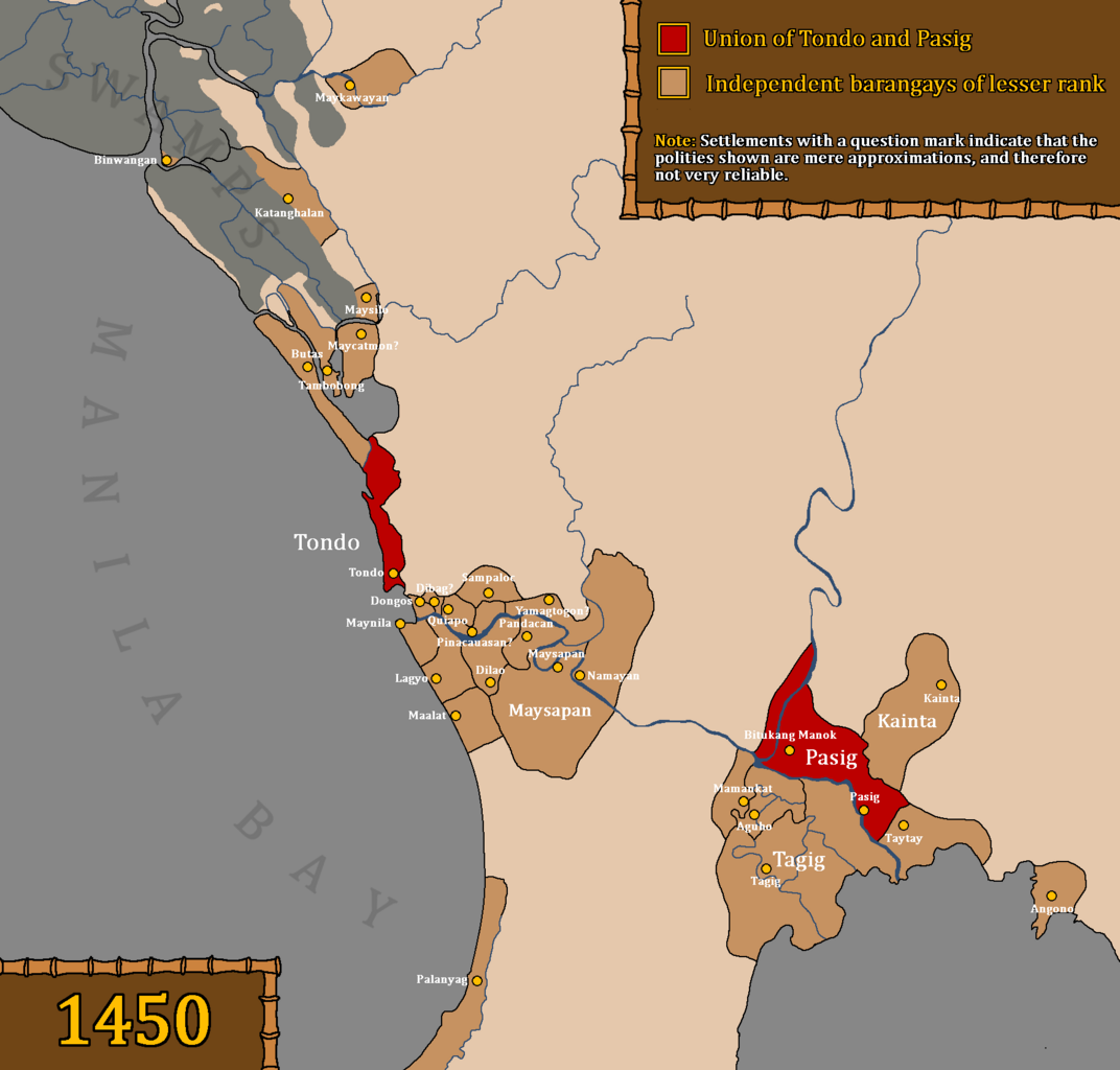
Map of the Union of Tondo and Pasig, also referred to as the Kingdom of Tondo, as well as other influenced barangays during the rule of Dayang Kalangitan in 경1450. This map uses question marks for places whose locations are deemed uncertain and not fully reliable. Interpretations based on "Estado, Topográfico, Estadistíco, Histórico—Religioso, de la Santa y Apostólica Provincia de San Gregorio Magno, de Religiosos Menores Descalzos de la Regular y Mas Estrecha Observancia De Nuestro Padre San Francisco, en las Islas Filipinas" by Fr. Felix Huerta Places like Meycatmon, Dibag, Pinacauasan, and Yamagtogon have uncertain locations, but are placed with approximate locations because Fr. Felix Huerta seems to have arranged the settlements in the right order, from Meycatmon "hasta" (until) Meysapan (Santa Ana). So, from Meycatmon all the way to Meysapan. Meycatmon (potentially the barangay of Catmon north of Tondo), Calatondongan (Tondo/Tondong/Tundun), Dongos (Santo Cristo de Longos, modern-day Binondo and San Nicolas), Dibag, Pinacauasan, Yamagtogon until Meysapan. Santa Cruz, San Miguel, and Santa Mesa do not have precolonial names preserved, despite having proof that it was inhabited prior to Spanish colonization. Therefore, in the area from Santa Cruz to Santa Mesa are the likely locations of Dibag, Pinacauasan and Yamagtogon, in a left-to-right order. Another thing that the author wants to clarify is that Namayan was a confederation and not a single entity, and as stated in Fr. Felix Huerta's work, ruled by a "petty king" named Lakan Tagkan. While the confederation was most likely headed by Namayan by 1570, this did not mean that they had direct control over other barangays. Also, there is no proof that Namayan held some degree of control over the mentioned territories in Fr. Felix Huerta's document before Lakan Tagkan. Furthermore, the excavations of old Chinese goods and piloncitos found in Santa Ana as stated in the Namayan Wikipedia page are not an indicator of Namayan's territories and influence. It was simply a proof of economic relations with the states around them. Furthermore, if we make logical estimates as to when Lakan Tagkan may have possibly ruled, based on genealogical records and the potential lifespan of people at the time, Lakan Tagkan may have only ruled in the mid to late 1400s. Lakan Tagkan is the great grandfather of Calamayin, who ruled during the 1570s. Fr. Felix Huerta also mentions that the "origins of the naturales of these territories" came from the kingdom established by Lakan Tagkan, so it is certain that Namayan only started dominating under Lakan Tagkan. Pasay was not included as it was a newly established settlement only during the reign of Lakan Tagkan, and this map precedes the reign of Lakan Tagkan of Namayan. There is also no proof that Namayan and Meysapan are the same entity. Fr. Felix Huerta has made it clear that Namayan was merely absorbed into Santa Ana de Sapa into a barrio (village) during the Spanish era. He did not mention that Meysapan was the seat of power, but Namayan. He further stated that Meysapan was only a territory of Namayan, never mentioning that Meysapan was ever Namayan. This was an indication that Meysapan (Sapa) and Namayan were two different settlements. Therefore, Namayan (in Mandaluyong) was the capital of Namayan, not Santa Ana de Sapa. Santa Ana was only made the seat of power of large swathes of areas during the Spanish era. It is very possible but not certain that Fr. Felix Huerta misinterpreted the barangays within the confederation headed by Namayan as Namayan's "territories", as no older Spanish accounts prior to Felix Huerta's work in the 19th century seem to mention various places all as part of one centralized kingdom known as Namayan. Furthermore, places like Pandacan, Taguig, Catanghalan, Maysilo/Misil, Polo, Tambobong, Navotas, and other areas clearly had their own local datus, hence they were able to take part in the Tondo Conspiracy of 1587. Binwangan (Binwangan, Obando) was also mentioned in the Laguna Copperplate Inscription. It is also not unlikely for Tondo to be absorbed into the confederation headed by Namayan under Lakan Tagkan. As stated by Nick Joaquin, that Tondo had "replaced Namayan as the chief port of entry on Manila Bay", indicating that Tondo may have only recently became increasingly less dependent and eventually became independent from Namayan. Fr. Felix Huerta made mention of Pandacan as part of Namayan, but as stated before, and according to older Spanish sources, this place had its own local datu. The Spaniards as well as Chinese records have a history of simplifying this confederation system in Luzon, insofar as simplifying them as the "Kingdom of Tondo" (Spanish records) or the "Kingdom of Lusung" (History of Ming). It is the best option to take account of these clear biases when portraying or discussing the system of governance in the pre-colonial Tagalog region. |
| 날짜 | |
| 출처 |
Original work by DeliriumMaps (Delirium333). The information was gathered from the following sources: Wikipedia Sources
Other Sources
|
| 저자 | Delirium333 |
라이선스

|
GNU 자유 문서 사용 허가서 1.2판 또는 자유 소프트웨어 재단에서 발행한 이후 판의 규정에 따라 본 문서를 복제하거나 개작 및 배포할 수 있습니다. 본 문서에는 변경 불가 부분이 없으며, 앞 표지 구절과 뒷 표지 구절도 없습니다. 본 사용 허가서의 전체 내용은 GNU 자유 문서 사용 허가서 부분에 포함되어 있습니다. |
- 이용자는 다음의 권리를 갖습니다:
- 공유 및 이용 – 저작물의 복제, 배포, 전시, 공연 및 공중송신
- 재창작 – 저작물의 개작, 수정, 2차적저작물 창작
- 다음과 같은 조건을 따라야 합니다:
- 저작자표시 – 적절한 저작자 표시를 제공하고, 라이센스에 대한 링크를 제공하고, 변경사항이 있는지를 표시해야 합니다. 당신은 합리적인 방식으로 표시할 수 있지만, 어떤 방식으로든 사용권 허가자가 당신 또는 당신의 사용을 지지하는 방식으로 표시할 수 없습니다.
- 동일조건변경허락 – 만약 당신이 이 저작물을 리믹스 또는 변형하거나 이 저작물을 기반으로 제작하는 경우, 당신은 당신의 기여물을 원저작물과 동일하거나 호환 가능한 라이선스에 따라 배포하여야 합니다.
파일 역사
날짜/시간 링크를 클릭하면 해당 시간의 파일을 볼 수 있습니다.
| 날짜/시간 | 섬네일 | 크기 | 사용자 | 설명 | |
|---|---|---|---|---|---|
| 현재 | 2024년 4월 14일 (일) 11:09 | | 1,778 × 1,699 (90 KB) | Delirium333 | the swamps were bigger than initially portrayed |
| 2024년 4월 12일 (금) 18:07 |  | 1,778 × 1,699 (89 KB) | Delirium333 | removed polo as it most likely wasnt a precolonial settlement and theres no evidence for it so im removing it | |
| 2024년 4월 11일 (목) 06:25 |  | 1,778 × 1,699 (90 KB) | Delirium333 | clarified the distinction of waters and swamps | |
| 2024년 4월 9일 (화) 18:59 |  | 1,778 × 1,699 (82 KB) | Delirium333 | added mamancat and aguho, expanded the territorial scope of maysapan, additional sources were also added in the desc | |
| 2024년 4월 8일 (월) 22:32 |  | 1,778 × 1,699 (79 KB) | Delirium333 | added lagyo | |
| 2024년 4월 8일 (월) 22:08 |  | 1,778 × 1,699 (79 KB) | Delirium333 | slight modification of the pasig river, this is purely cosmetic and the difference is only by mere pixels | |
| 2024년 4월 8일 (월) 22:06 |  | 1,778 × 1,699 (79 KB) | Delirium333 | mainly a change of color choice to avoid misconceptions | |
| 2023년 9월 18일 (월) 22:48 |  | 1,778 × 1,699 (78 KB) | Delirium333 | made cosmetic changes, cuz i accidentally painted a tiny pixel area with the wrong color, i want my map looking professional and clean | |
| 2023년 9월 18일 (월) 20:53 |  | 1,778 × 1,699 (78 KB) | Delirium333 | fixed a lot of mistakes after rereading fr. felix huerta's document. one major mistake was including taguig as part of namayan when it was not. also there was no proof namayan held large territories before lakan tagkan. and lakan tagkan if we make geneaological estimates was most likely the ruler of namayan only in the mid to late 1400s | |
| 2023년 9월 17일 (일) 00:28 |  | 1,778 × 1,699 (150 KB) | Delirium333 | modified the border of dongos and tondo |
이 파일을 사용하는 문서
다음 문서 1개가 이 파일을 사용하고 있습니다:
이 파일을 사용하고 있는 모든 위키의 문서 목록
다음 위키에서 이 파일을 사용하고 있습니다:
- en.wikipedia.org에서 이 파일을 사용하고 있는 문서 목록
- es.wikipedia.org에서 이 파일을 사용하고 있는 문서 목록
- it.wikipedia.org에서 이 파일을 사용하고 있는 문서 목록
- pt.wikipedia.org에서 이 파일을 사용하고 있는 문서 목록
- ru.wikipedia.org에서 이 파일을 사용하고 있는 문서 목록
- sr.wikipedia.org에서 이 파일을 사용하고 있는 문서 목록
- tl.wikipedia.org에서 이 파일을 사용하고 있는 문서 목록
- zh.wikipedia.org에서 이 파일을 사용하고 있는 문서 목록