
파일:Texel.jpg
최대 해상도입니다.
Texel.jpg (800 × 600 픽셀, 파일 크기: 44 KB, MIME 종류: image/jpeg)
파일 설명
| 설명 |
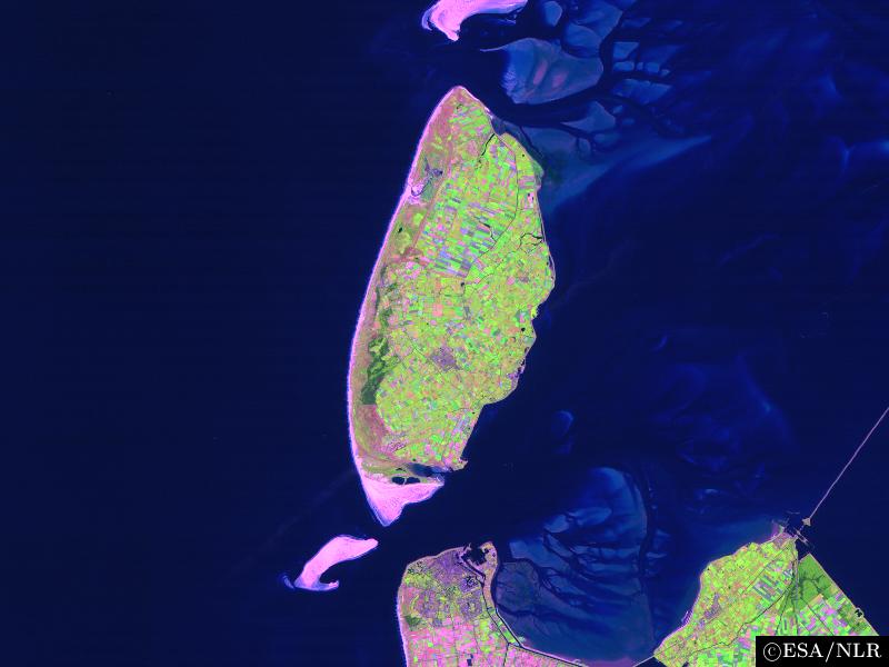
en:False colour en:satellite en:image of the en:island of en:Texel and its surroundings. The image was made by NLR and ESA.NLR and ESA are cited as its source. To the south of the island, part of the en:mainland of the Dutch en:province of en:North Holland can be seen, including the en:city of en:Den Helder (bottom center) and the former island of en:Wieringen (bottom right). Further features include the sand bar of en:Noorderhaaks to the southwest of Texel; the southernmost part of the neighbouring island of en:Vlieland (top center); the en:Afsluitdijk en:dam, which connects North Holland to en:Friesland (center right), the en:Wadden Sea, east of Texel; and the en:North Sea (west of Texel). |
| 날짜 | 2004년 8월 23일 (원본 올리기 일시) |
| 출처 | en.wikipedia에서 공용으로 옮겨왔습니다. |
| 저자 | The original uploader was 영어 위키백과의 Cwoyte. |
라이선스

|
이 파일의 저작권자는 저작권자를 명시한다는 조건에 따라 누구에게나 어떤 목적으로든지 사용할 수 있도록 허용합니다.
이 저작물의 재배포나 이차적 저작물 작성 및 상업적 이용 등이 허용됩니다. |
|
|
기존 올리기 기록
The original description page was here. All following user names refer to en.wikipedia.
- 2004-08-23 09:49 Cwoyte 800×600×8 (45082 bytes) Satellite image of the island of Texel and its surroundings.
파일 역사
날짜/시간 링크를 클릭하면 해당 시간의 파일을 볼 수 있습니다.
| 날짜/시간 | 섬네일 | 크기 | 사용자 | 설명 | |
|---|---|---|---|---|---|
| 현재 | 2007년 5월 22일 (화) 02:53 | | 800 × 600 (44 KB) | Matanya (usurped) | {{Information |Description=en:False colour en:satellite en:image of the en:island of en:Texel and its surroundings. The image was made by [http://www.npoc.nl NLR] and [http://www.esa.int ESA].NLR and ESA are cited as its source. |
이 파일을 사용하는 문서
다음 문서 1개가 이 파일을 사용하고 있습니다:
이 파일을 사용하고 있는 모든 위키의 문서 목록
다음 위키에서 이 파일을 사용하고 있습니다:
- br.wikipedia.org에서 이 파일을 사용하고 있는 문서 목록
- de.wiktionary.org에서 이 파일을 사용하고 있는 문서 목록
- fa.wikipedia.org에서 이 파일을 사용하고 있는 문서 목록
- fi.wikipedia.org에서 이 파일을 사용하고 있는 문서 목록
- he.wikipedia.org에서 이 파일을 사용하고 있는 문서 목록
- is.wikipedia.org에서 이 파일을 사용하고 있는 문서 목록
- ja.wikipedia.org에서 이 파일을 사용하고 있는 문서 목록
- ka.wikipedia.org에서 이 파일을 사용하고 있는 문서 목록
- nl.wikipedia.org에서 이 파일을 사용하고 있는 문서 목록
- th.wikipedia.org에서 이 파일을 사용하고 있는 문서 목록
- vi.wikipedia.org에서 이 파일을 사용하고 있는 문서 목록
- www.wikidata.org에서 이 파일을 사용하고 있는 문서 목록
- zh.wikipedia.org에서 이 파일을 사용하고 있는 문서 목록