
파일:StratifiedPoints.gif
StratifiedPoints.gif (400 × 400 픽셀, 파일 크기: 1.34 MB, MIME 종류: image/gif, 반복됨, 100 프레임, 2 min 0 s)
파일 설명
| 설명 |
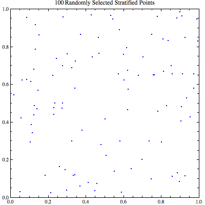
English: (*The stratification process redistributes the random elements into a \
relatively homogeneous group and then samples randomly. Every element \ in the original set is uniquely reassigned to one stratum.*) \ tinyColor[color_, point_] := {PointSize[Small], color, Point[point]} colorChoose[point_] := tinyColor[Blue, point] Clear[r, n]; r = 100; n = r^2; darts = RandomReal[{0, 1}, {n, 2}]; coloredDarts = ParallelMap[colorChoose, darts]; Clear[smoothedDarts, tempPoints] subGrouper = Table[i, {i, 0, r - 1}]; shiftyGuy = Flatten[Tuples[subGrouper, 2]]; tempPoints = Partition[(shiftyGuy + Flatten[darts])*(1/r), 2]; smoothedDarts = RandomSample[tempPoints, n]; Export["~/Desktop/stratifiedPoints.gif", Table[ListPlot[Part[smoothedDarts, 1 ;; max], AspectRatio -> 1,
PlotStyle -> {PointSize[Small], Blue},
PlotRange -> {{0, 1}, {0, 1}},
PlotLabel ->
TraditionalForm[max "Randomly Selected Stratified Points"],
Frame -> True, ImageSize -> {400, 400}], {max, 100, Length[darts],
Length[darts]/100}],
"DisplayDurations" -> ConstantArray[1, 9]~Join~{3}] |
| 날짜 | |
| 출처 | 자작 |
| 저자 | Caitlin Jo Ramsey |
| 카메라 위치 | | 이 지역의 다른 사진을 보기: OpenStreetMap |
|---|
(*This mathematical image was created with Mathematica. The stratification process redistributes the random elements into a \ relatively homogeneous group and then samples randomly. Every element \ in the original set is uniquely reassigned to one stratum. Source code for this image is available below.*) \ tinyColor[color_, point_] := {PointSize[Small], color, Point[point]} colorChoose[point_] := tinyColor[Blue, point]
Clear[r, n]; r = 100; n = r^2; darts = RandomReal[{0, 1}, {n, 2}]; coloredDarts = ParallelMap[colorChoose, darts];
Clear[smoothedDarts, tempPoints] subGrouper = Table[i, {i, 0, r - 1}]; shiftyGuy = Flatten[Tuples[subGrouper, 2]]; tempPoints = Partition[(shiftyGuy + Flatten[darts])*(1/r), 2];
smoothedDarts = RandomSample[tempPoints, n];
Export["~/Desktop/stratifiedPoints.gif",
Table[ListPlot[Part[smoothedDarts, 1 ;; max], AspectRatio -> 1,
  PlotStyle -> {PointSize[Small], Blue},
  PlotRange -> {{0, 1}, {0, 1}},
  PlotLabel ->
   TraditionalForm[max "Randomly Selected Stratified Points"],
  Frame -> True, ImageSize -> {400, 400}], {max, 100, Length[darts],
  Length[darts]/100}],
"DisplayDurations" -> ConstantArray[1, 9]~Join~{3}]
라이선스
- 이용자는 다음의 권리를 갖습니다:
- 공유 및 이용 – 저작물의 복제, 배포, 전시, 공연 및 공중송신
- 재창작 – 저작물의 개작, 수정, 2차적저작물 창작
- 다음과 같은 조건을 따라야 합니다:
- 저작자표시 – 적절한 저작자 표시를 제공하고, 라이센스에 대한 링크를 제공하고, 변경사항이 있는지를 표시해야 합니다. 당신은 합리적인 방식으로 표시할 수 있지만, 어떤 방식으로든 사용권 허가자가 당신 또는 당신의 사용을 지지하는 방식으로 표시할 수 없습니다.
- 동일조건변경허락 – 만약 당신이 이 저작물을 리믹스 또는 변형하거나 이 저작물을 기반으로 제작하는 경우, 당신은 당신의 기여물을 원저작물과 동일하거나 호환 가능한 라이선스에 따라 배포하여야 합니다.
파일 역사
날짜/시간 링크를 클릭하면 해당 시간의 파일을 볼 수 있습니다.
| 날짜/시간 | 섬네일 | 크기 | 사용자 | 설명 | |
|---|---|---|---|---|---|
| 현재 | 2013년 7월 15일 (월) 03:10 | | 400 × 400 (1.34 MB) | CaitlinJo | User created page with UploadWizard |
이 파일을 사용하는 문서
다음 문서 1개가 이 파일을 사용하고 있습니다:
이 파일을 사용하고 있는 모든 위키의 문서 목록
다음 위키에서 이 파일을 사용하고 있습니다:
- en.wikipedia.org에서 이 파일을 사용하고 있는 문서 목록
- ja.wikipedia.org에서 이 파일을 사용하고 있는 문서 목록