
파일:Southwest map.png

미리 보기 크기: 800 × 520 픽셀 다른 해상도: 320 × 208 픽셀 | 640 × 416 픽셀 | 1,024 × 666 픽셀 | 1,280 × 832 픽셀
원본 파일 (1,280 × 832 픽셀, 파일 크기: 199 KB, MIME 종류: image/png)
파일 설명
| 설명 |
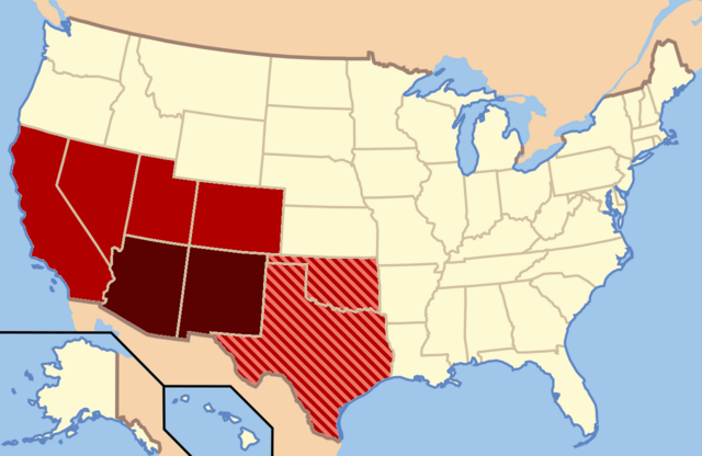
Dark Red: Almost always considered the Southwest |
| 날짜 | |
| 출처 | 자작 |
| 저자 | Secret Saturdays |
라이선스
| 나는 이 작품의 저작권자로서, 이 작품을 퍼블릭 도메인으로 모두에게 공개합니다. 이 공개 선언은 전 세계적으로 유효합니다. 만약 저작권의 포기가 법률적으로 가능하지 않은 경우, 나는 이 작품을 법적으로 허용되는 한도 내에서 누구나 자유롭게 어떤 목적으로도 제한없이 사용할 수 있도록 허용합니다. |
파일 역사
날짜/시간 링크를 클릭하면 해당 시간의 파일을 볼 수 있습니다.
| 날짜/시간 | 섬네일 | 크기 | 사용자 | 설명 | |
|---|---|---|---|---|---|
| 현재 | 2022년 2월 9일 (수) 12:20 | | 1,280 × 832 (199 KB) | Quackslikeaduck | Reverted to version as of 20:03, 25 August 2016 (UTC); Kansas is not considered part of the American Southwest, not even geographically. |
| 2020년 8월 1일 (토) 06:39 |  | 1,280 × 832 (159 KB) | Rubensbathsheba | Kansas may sometimes be considered part of the Southwest geographically. | |
| 2016년 8월 26일 (금) 05:03 |  | 1,280 × 832 (199 KB) | WClarke | Instead of using dark red, red, and blue stripes, this version uses dark red, red, and red stripes. Everything being red makes the map look more uniform. | |
| 2009년 7월 24일 (금) 07:53 |  | 572 × 371 (21 KB) | Secret Saturdays | {{Information |Description={{en|1=The Dark Red states mean they are almost always considered Southwest states, The light red states mean they are rarely considered Southwest states and the Blue States mean they are conisdered Southwest and Southern states |
이 파일을 사용하는 문서
다음 문서 1개가 이 파일을 사용하고 있습니다:
이 파일을 사용하고 있는 모든 위키의 문서 목록
다음 위키에서 이 파일을 사용하고 있습니다:
- ar.wikipedia.org에서 이 파일을 사용하고 있는 문서 목록
- cs.wikipedia.org에서 이 파일을 사용하고 있는 문서 목록
- de.wikipedia.org에서 이 파일을 사용하고 있는 문서 목록
- en.wikipedia.org에서 이 파일을 사용하고 있는 문서 목록
- eo.wikipedia.org에서 이 파일을 사용하고 있는 문서 목록
- fy.wikipedia.org에서 이 파일을 사용하고 있는 문서 목록
- he.wikipedia.org에서 이 파일을 사용하고 있는 문서 목록
- id.wikipedia.org에서 이 파일을 사용하고 있는 문서 목록
- ru.wikipedia.org에서 이 파일을 사용하고 있는 문서 목록
- sv.wikipedia.org에서 이 파일을 사용하고 있는 문서 목록
- tr.wikipedia.org에서 이 파일을 사용하고 있는 문서 목록
- ur.wikipedia.org에서 이 파일을 사용하고 있는 문서 목록
- vi.wikipedia.org에서 이 파일을 사용하고 있는 문서 목록
- www.wikidata.org에서 이 파일을 사용하고 있는 문서 목록