
파일:Siirt districts.png

미리 보기 크기: 776 × 600 픽셀 다른 해상도: 311 × 240 픽셀 | 621 × 480 픽셀 | 994 × 768 픽셀 | 1,056 × 816 픽셀
원본 파일 (1,056 × 816 픽셀, 파일 크기: 32 KB, MIME 종류: image/png)
파일 설명
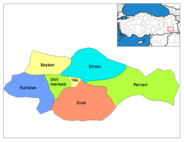
| 설명 | Map of the districts of Siirt province in Turkey. Created by Rarelibra 17:13, 4 December 2006 (UTC) for public domain use, using MapInfo Professional v8.5 and various mapping resources. Edited by One Homo Sapiens Corrected text where İ,Ş,ı,ğ,or ş occurs in name. Source: [statoids-com]. Increased font size and enhanced color differences among adjacent districts. |
| 날짜 | 2006년 12월 4일 (원본 올리기 일시) |
| 출처 | No machine-readable source provided. Own work assumed (based on copyright claims). |
| 저자 | No machine-readable author provided. Rarelibra assumed (based on copyright claims). |
라이선스
| 나는 이 작품의 저작권자로서, 이 작품을 퍼블릭 도메인으로 모두에게 공개합니다. 이 공개 선언은 전 세계적으로 유효합니다. 만약 저작권의 포기가 법률적으로 가능하지 않은 경우, 나는 이 작품을 법적으로 허용되는 한도 내에서 누구나 자유롭게 어떤 목적으로도 제한없이 사용할 수 있도록 허용합니다. |
파일 역사
날짜/시간 링크를 클릭하면 해당 시간의 파일을 볼 수 있습니다.
| 날짜/시간 | 섬네일 | 크기 | 사용자 | 설명 | |
|---|---|---|---|---|---|
| 현재 | 2015년 1월 1일 (목) 02:49 | | 1,056 × 816 (32 KB) | Sae1962 | Trying the same upload again... |
| 2015년 1월 1일 (목) 02:47 |  | 1,056 × 816 (32 KB) | Sae1962 | Corrected the district name „Aydınlar“ to „Tillo“, as it has been renamed to this old name on the 7. November 2013 (see Turkish Wikipedia article about Tillo for details). | |
| 2008년 12월 29일 (월) 11:05 |  | 1,056 × 816 (24 KB) | One Homo Sapiens | Corrected text where İ,Ş,ı,ğ,or ş occurs in name. Source: [statoids-com]. Increased font size and enhanced color differences among adjacent districts. | |
| 2006년 12월 5일 (화) 02:13 |  | 1,056 × 816 (27 KB) | Rarelibra | Map of the districts of Siirt province in Turkey. Created by ~~~~ for public domain use, using MapInfo Professional v8.5 and various mapping resources. |
이 파일을 사용하는 문서
다음 문서 1개가 이 파일을 사용하고 있습니다:
이 파일을 사용하고 있는 모든 위키의 문서 목록
다음 위키에서 이 파일을 사용하고 있습니다:
- ar.wikipedia.org에서 이 파일을 사용하고 있는 문서 목록
- ast.wikipedia.org에서 이 파일을 사용하고 있는 문서 목록
- az.wikipedia.org에서 이 파일을 사용하고 있는 문서 목록
- ca.wikipedia.org에서 이 파일을 사용하고 있는 문서 목록
- ceb.wikipedia.org에서 이 파일을 사용하고 있는 문서 목록
- cs.wikipedia.org에서 이 파일을 사용하고 있는 문서 목록
- de.wikipedia.org에서 이 파일을 사용하고 있는 문서 목록
- diq.wikipedia.org에서 이 파일을 사용하고 있는 문서 목록
- en.wikipedia.org에서 이 파일을 사용하고 있는 문서 목록
- en.wiktionary.org에서 이 파일을 사용하고 있는 문서 목록
- eo.wikipedia.org에서 이 파일을 사용하고 있는 문서 목록
- es.wikipedia.org에서 이 파일을 사용하고 있는 문서 목록
- eu.wikipedia.org에서 이 파일을 사용하고 있는 문서 목록
- fa.wikipedia.org에서 이 파일을 사용하고 있는 문서 목록
- fi.wikipedia.org에서 이 파일을 사용하고 있는 문서 목록
- fr.wikipedia.org에서 이 파일을 사용하고 있는 문서 목록
- hu.wikipedia.org에서 이 파일을 사용하고 있는 문서 목록
- hy.wikipedia.org에서 이 파일을 사용하고 있는 문서 목록
- id.wikipedia.org에서 이 파일을 사용하고 있는 문서 목록
이 파일의 더 많은 사용 내역을 봅니다.