
파일:ShepherdByzempire1265.jpg
미리 보기 크기: 762 × 599 픽셀 다른 해상도: 305 × 240 픽셀 | 610 × 480 픽셀 | 976 × 768 픽셀 | 1,144 × 900 픽셀
원본 파일 (1,144 × 900 픽셀, 파일 크기: 281 KB, MIME 종류: image/jpeg)
파일 설명
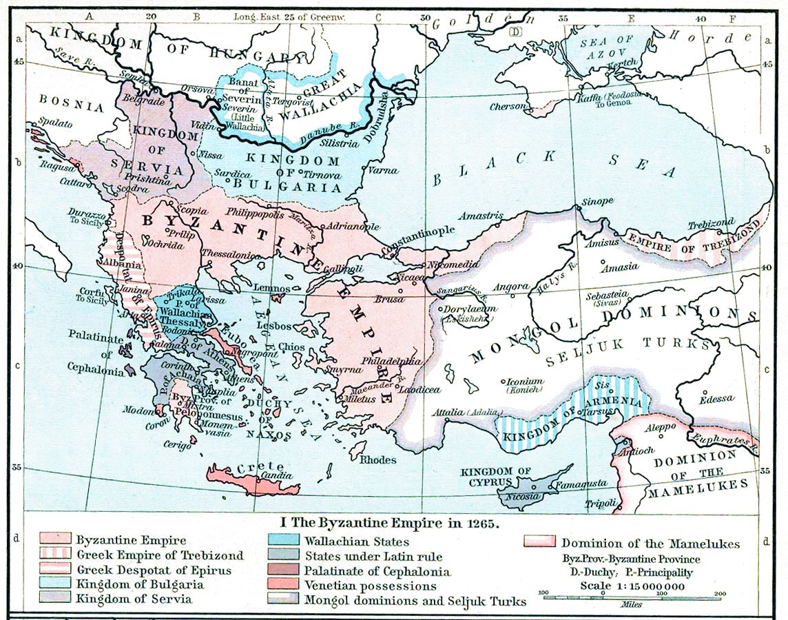
| 설명 | Map, The Byzantine Empire, 1265. |
| 날짜 | |
| 출처 | The Historical Atlas, William R. Shepherd, 1911. |
| 저자 | |
| 다른 버전 |
이 파일은 다음으로 파생됨: |

|
이 그림 파일은 벡터 SVG 형식으로 다시 만들어야 합니다. SVG의 장점에 대해서는 여기(영어)를 참고해 주십시오. 만약 이 그림의 SVG 버전이 이미 존재한다면 이 틀을 {{vector version available|새 파일 이름.svg}}으로 대체해 주십시오.
|


라이선스
|
이 작품은 미국, 그리고 저작권 보호 기간이 저작자 사후 70년, 또는 그 이하인 모든 국가에서 퍼블릭 도메인입니다.
| |
| 이 저작물은 모든 저작인접권을 포함한 저작권법하의 규제로부터 자유로운 것으로 확인되었습니다. | |
This media file is in the public domain in the United States. This applies to U.S. works where the copyright has expired, often because its first publication occurred prior to January 1, 1929, and if not then due to lack of notice or renewal. See this page for further explanation.
|
 | |
 |
This image might not be in the public domain outside of the United States; this especially applies in the countries and areas that do not apply the rule of the shorter term for US works, such as Canada, Mainland China (not Hong Kong or Macao), Germany, Mexico, and Switzerland. The creator and year of publication are essential information and must be provided. See Wikipedia:Public domain and Wikipedia:Copyrights for more details.
|
파일 역사
날짜/시간 링크를 클릭하면 해당 시간의 파일을 볼 수 있습니다.
| 날짜/시간 | 섬네일 | 크기 | 사용자 | 설명 | |
|---|---|---|---|---|---|
| 현재 | 2022년 11월 17일 (목) 00:28 | | 1,144 × 900 (281 KB) | Gyalu22 | Reverted to version as of 16:26, 12 July 2009 (UTC) |
| 2016년 5월 20일 (금) 23:49 |  | 1,144 × 900 (858 KB) | Julieta39 | Cosmetic (see discussion file) | |
| 2009년 7월 13일 (월) 01:26 |  | 1,144 × 900 (281 KB) | Alex:D | whitened | |
| 2009년 7월 13일 (월) 01:17 |  | 1,144 × 900 (281 KB) | Alex:D | whitened | |
| 2009년 7월 13일 (월) 01:12 |  | 1,144 × 900 (281 KB) | Alex:D | whitened | |
| 2004년 12월 21일 (화) 22:40 |  | 1,144 × 900 (272 KB) | Mschlindwein | Map, The Byzantine Empire, 1265. The Historical Atlas, William R. Shepherd, 1911. |
이 파일을 사용하는 문서
이 파일을 사용하고 있는 모든 위키의 문서 목록
다음 위키에서 이 파일을 사용하고 있습니다:
- an.wikipedia.org에서 이 파일을 사용하고 있는 문서 목록
- ar.wikipedia.org에서 이 파일을 사용하고 있는 문서 목록
- azb.wikipedia.org에서 이 파일을 사용하고 있는 문서 목록
- az.wikipedia.org에서 이 파일을 사용하고 있는 문서 목록
- be-tarask.wikipedia.org에서 이 파일을 사용하고 있는 문서 목록
- be.wikipedia.org에서 이 파일을 사용하고 있는 문서 목록
- bg.wikipedia.org에서 이 파일을 사용하고 있는 문서 목록
- ca.wikipedia.org에서 이 파일을 사용하고 있는 문서 목록
- cs.wikipedia.org에서 이 파일을 사용하고 있는 문서 목록
- de.wikipedia.org에서 이 파일을 사용하고 있는 문서 목록
- el.wikipedia.org에서 이 파일을 사용하고 있는 문서 목록
- en.wikipedia.org에서 이 파일을 사용하고 있는 문서 목록
이 파일의 더 많은 사용 내역을 봅니다.