
파일:Sanson Amerique Septentrionale 1650 UTA.jpg

미리 보기 크기: 800 × 561 픽셀 다른 해상도: 320 × 224 픽셀 | 640 × 448 픽셀 | 1,024 × 718 픽셀 | 1,280 × 897 픽셀 | 2,560 × 1,794 픽셀 | 3,836 × 2,688 픽셀
원본 파일 (3,836 × 2,688 픽셀, 파일 크기: 1.89 MB, MIME 종류: image/jpeg)
파일 설명
| 제목 |
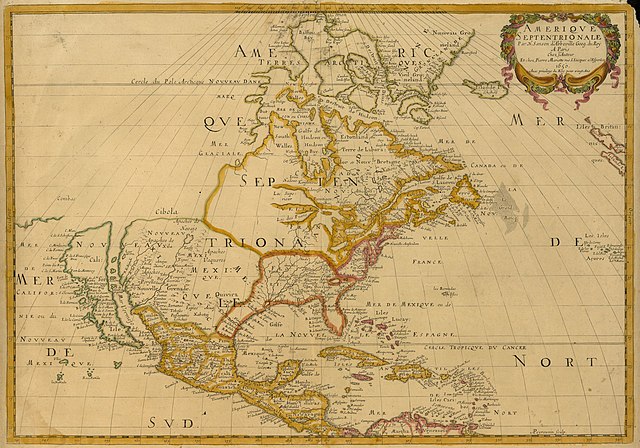
Français : Amerique Septentrionale |
||||||||||||||||||||||||||
| 묘사 |
English: Sanson's landmark 1650 map of North America includes interesting details relating to chartered company operations in the northern and eastern part of the continent as well as the Caribbean. Employing a sinusoidal projection, its construction demonstrates considerable scientific acumen. Much of the Great Lakes system now appears, with Lakes Superior and Ontario named for the first time. Sanson's sources must have included the annual reports of the Jesuits which included eyewitness accounts of their missionary activities and explorations in association with the chartered fur companies. These augmented the earlier explorations of Champlain. There is also "Mon Royal", or Montreal, laid out as a trading site by Champlain in 1611. "N[ouvelle]. Anglet[erre]" refers to New England, while "Nouvelle Amsterdam" and "Nouvelle Hollandia" on the east coast allude to activities there of the New Netherland Company (beginning in 1614) and the Dutch WIC (beginning in 1625). There is even "N[ouvelle]. Suede" relating to the new settlements in the Delaware Valley of the New Sweden Company chartered by the Swedish government in 1638. |
||||||||||||||||||||||||||
| 날짜 | 1650년 또는 1651년 | ||||||||||||||||||||||||||
| 출처 | UTA Libraries Cartographic Connections: 지도 / text | ||||||||||||||||||||||||||
| 창작자 |
|
||||||||||||||||||||||||||
| 크레디트 라인 |
English: UTA Libraries Special Collections |
||||||||||||||||||||||||||
| 지리 정보 | |||||||||||||||||||||||||||
| 지도 위치 | 북아메리카 | ||||||||||||||||||||||||||
| 지리 참고 | 부적절한 경우에 숨기려면 warp_status = skip로 설정하세요. | ||||||||||||||||||||||||||
| 출판 장소 | 파리 | ||||||||||||||||||||||||||
| 보관 기록 자료 | |||||||||||||||||||||||||||
| Collection |
|
||||||||||||||||||||||||||
| 크기 | 높이: 38 cm; 너비: 54 cm | ||||||||||||||||||||||||||
| 기법 | colored engraving | ||||||||||||||||||||||||||
| artwork-references |
Burden The Mapping of North America I, no. 294 , pp. 375−377 Schwartz and Ralph Ehrenberg The Mapping of America, 5, no. 61 , pp. 111−112 Hayes Historical Atlas of Canada, 1, p. 60 Martin 와 Martin Maps of Texas and the Southwest, 1, pp. 82−83 |
||||||||||||||||||||||||||

라이선스

|
This file was provided to Wikimedia Commons by the University of Texas at Arlington Libraries as part of a cooperation project. The University of Texas at Arlington Libraries is part of the University of Texas at Arlington, a public research university located in Arlington, Texas.
|
|
저작자가 1667년에 사망한 이 작품은 미국, 그리고 저작권 보호 기간이 저작자 사후 100년, 또는 그 이하인 모든 국가에서 퍼블릭 도메인입니다. 이 작품은 1929년 1월 1일 이전에 출판하였으므로 미국에서 퍼블릭 도메인입니다. | |
| 이 저작물은 모든 저작인접권을 포함한 저작권법하의 규제로부터 자유로운 것으로 확인되었습니다. | |
파일 역사
날짜/시간 링크를 클릭하면 해당 시간의 파일을 볼 수 있습니다.
| 날짜/시간 | 섬네일 | 크기 | 사용자 | 설명 | |
|---|---|---|---|---|---|
| 현재 | 2022년 2월 9일 (수) 00:27 | | 3,836 × 2,688 (1.89 MB) | Michael Barera | == {{int:filedesc}} == {{Map |title = {{la|'''''Amerique Septentrionale'''''}} |description = {{en|Sanson's landmark 1650 map of North America includes interesting details relating to chartered company operations in the northern and eastern part of the continent as well as the Caribbean. Employing a sinusoidal projection, its construction demonstrates considerable scientific acumen. Much of the Great Lakes system now appears, with Lakes Superior and Ontario named for the f... |
이 파일을 사용하는 문서
다음 문서 1개가 이 파일을 사용하고 있습니다:
이 파일을 사용하고 있는 모든 위키의 문서 목록
다음 위키에서 이 파일을 사용하고 있습니다:
- de.wikipedia.org에서 이 파일을 사용하고 있는 문서 목록
- en.wikipedia.org에서 이 파일을 사용하고 있는 문서 목록
- es.wikipedia.org에서 이 파일을 사용하고 있는 문서 목록
- fa.wikipedia.org에서 이 파일을 사용하고 있는 문서 목록
- it.wikipedia.org에서 이 파일을 사용하고 있는 문서 목록
- ja.wikipedia.org에서 이 파일을 사용하고 있는 문서 목록
- pt.wikipedia.org에서 이 파일을 사용하고 있는 문서 목록
- ru.wikipedia.org에서 이 파일을 사용하고 있는 문서 목록