
파일:Saint-Barthélemy collectivity relief location map.jpg

미리 보기 크기: 800 × 526 픽셀 다른 해상도: 320 × 210 픽셀 | 640 × 420 픽셀 | 1,024 × 673 픽셀 | 1,175 × 772 픽셀
원본 파일 (1,175 × 772 픽셀, 파일 크기: 172 KB, MIME 종류: image/jpeg)
파일 설명
| 카메라 위치 | | 이 지역의 다른 사진을 보기: OpenStreetMap |
|---|
| 설명 |
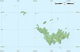
English: Blank physical map of the overseas collectivity of Saint Barthélemy, France, for geo-location purpose.
Français : Carte physique vierge de la collectivité d'outre-mer de Saint-Barthélemy, France, destinée à la géolocalisation. Scales: 1:372,000 (precision: 93 m) for the topography; 1:4,720,000 (precision: 1,180 m) for the bathymetry
Geographic limits of the map:
|
||
| 날짜 | |||
| 출처 |
자작
|
||
| 저자 | Eric Gaba (Sting - fr:Sting) | ||
| 저작권 (이 파일을 인용하기) |
|
||
| 다른 버전 |
|


라이선스
Eric Gaba, Wikimedia Commons user Sting은(는) 아래 작품의 저작권자로서, 해당 저작물을 다음과 같은 라이선스로 배포합니다.
이 파일은 크리에이티브 커먼즈 저작자표시-동일조건변경허락 3.0 Unported 라이선스로 배포됩니다.
저작자표시: Eric Gaba, Wikimedia Commons user Sting
- 이용자는 다음의 권리를 갖습니다:
- 공유 및 이용 – 저작물의 복제, 배포, 전시, 공연 및 공중송신
- 재창작 – 저작물의 개작, 수정, 2차적저작물 창작
- 다음과 같은 조건을 따라야 합니다:
- 저작자표시 – 적절한 저작자 표시를 제공하고, 라이센스에 대한 링크를 제공하고, 변경사항이 있는지를 표시해야 합니다. 당신은 합리적인 방식으로 표시할 수 있지만, 어떤 방식으로든 사용권 허가자가 당신 또는 당신의 사용을 지지하는 방식으로 표시할 수 없습니다.
- 동일조건변경허락 – 만약 당신이 이 저작물을 리믹스 또는 변형하거나 이 저작물을 기반으로 제작하는 경우, 당신은 당신의 기여물을 원저작물과 동일하거나 호환 가능한 라이선스에 따라 배포하여야 합니다.

|
GNU 자유 문서 사용 허가서 1.2판 또는 자유 소프트웨어 재단에서 발행한 이후 판의 규정에 따라 본 문서를 복제하거나 개작 및 배포할 수 있습니다. 본 문서에는 변경 불가 부분이 없으며, 앞 표지 구절과 뒷 표지 구절도 없습니다. 본 사용 허가서의 전체 내용은 GNU 자유 문서 사용 허가서 부분에 포함되어 있습니다. |
이 라이선스 중에서 목적에 맞는 것을 선택하여 사용할 수 있습니다.
파일 역사
날짜/시간 링크를 클릭하면 해당 시간의 파일을 볼 수 있습니다.
| 날짜/시간 | 섬네일 | 크기 | 사용자 | 설명 | |
|---|---|---|---|---|---|
| 현재 | 2010년 7월 19일 (월) 06:14 | | 1,175 × 772 (172 KB) | Sting | Color profile |
| 2010년 2월 26일 (금) 10:39 |  | 1,175 × 772 (167 KB) | Sting | == {{int:filedesc}} == {{Location|17|55|30|N|62|51|45|W|scale:50000}} <br/> {{Information |Description={{en|Blank physical map of the overseas collectivity of Saint Barthélemy, France |
이 파일을 사용하는 문서
다음 문서 1개가 이 파일을 사용하고 있습니다:
이 파일을 사용하고 있는 모든 위키의 문서 목록
다음 위키에서 이 파일을 사용하고 있습니다:
- ar.wikipedia.org에서 이 파일을 사용하고 있는 문서 목록
- ast.wikipedia.org에서 이 파일을 사용하고 있는 문서 목록
- bg.wikipedia.org에서 이 파일을 사용하고 있는 문서 목록
- bs.wikipedia.org에서 이 파일을 사용하고 있는 문서 목록
- ceb.wikipedia.org에서 이 파일을 사용하고 있는 문서 목록
- ckb.wikipedia.org에서 이 파일을 사용하고 있는 문서 목록
- da.wikipedia.org에서 이 파일을 사용하고 있는 문서 목록
- de.wikipedia.org에서 이 파일을 사용하고 있는 문서 목록
- en.wikipedia.org에서 이 파일을 사용하고 있는 문서 목록
- eo.wikipedia.org에서 이 파일을 사용하고 있는 문서 목록
- es.wikipedia.org에서 이 파일을 사용하고 있는 문서 목록
- fa.wikipedia.org에서 이 파일을 사용하고 있는 문서 목록
- fr.wikipedia.org에서 이 파일을 사용하고 있는 문서 목록
- Discussion utilisateur:Pethrus
- Gustavia (Saint-Barthélemy)
- Projet:Cartographie/Cartes standards/France
- Modèle:Géolocdual/Saint-Barthélemy
- Modèle:Géolocalisation/Saint-Barthélemy
- Wikipédia:Atelier graphique/Cartes/Archives/avril 2010
- Morne de Vitet
- Réserve naturelle nationale de Saint-Barthélemy Nicole-Aussedat
- Île Fourchue
- Île Chevreau
- Île Frégate (France)
- Île le Boulanger
- Île Coco
- Pain de Sucre (Saint-Barthélemy)
- Île Pelé
- Île Petit Jean
- Île Toc Vers
- La Tortue (Saint-Barthélemy)
- Liste des mammifères à Saint-Barthélemy
- he.wikipedia.org에서 이 파일을 사용하고 있는 문서 목록
- hr.wikipedia.org에서 이 파일을 사용하고 있는 문서 목록
이 파일의 더 많은 사용 내역을 봅니다.