
파일:RomanEmpire 117.svg

SVG 파일의 PNG 형식의 미리보기 크기: 512 × 376 픽셀. 다른 해상도: 320 × 235 픽셀 | 640 × 470 픽셀 | 1,024 × 752 픽셀 | 1,280 × 940 픽셀 | 2,560 × 1,880 픽셀
원본 파일 (SVG 파일, 실제 크기 512 × 376 픽셀, 파일 크기: 704 KB)
파일 설명
| 설명 |
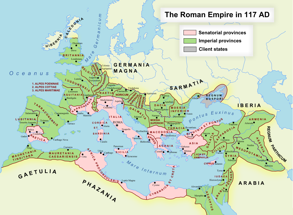
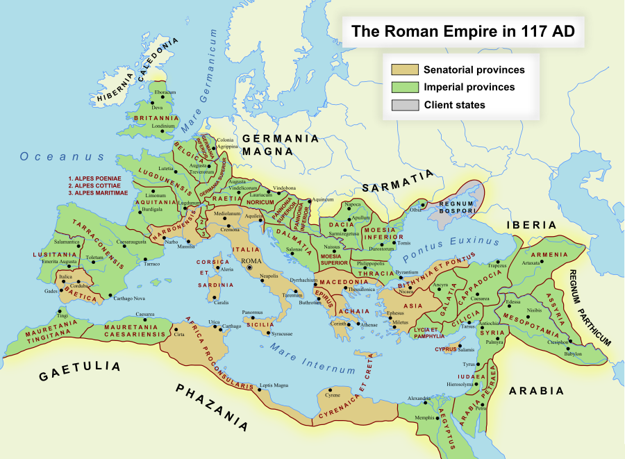
English: The maximum extent of the Roman Empire. Superimposed on a physical map. Senatorial Provinces Imperial Provinces Client States Español: Máxima extensión del Imperio Romano. Superpuesto en un mapa físico. Provincias Senatoriales Provincias Imperiales Estados satélite Deutsch: Das Römische Reich zur Zeit seiner maximalen Ausdehnung unter Trajan, 117 n. Chr. Senatorische Provinz Kaiserliche Provinz Klientelkönigtum Latina: Extentum maximum de Imperium Romanum. Provinciae senatus Provinciae Imperii Civitates Clientes 中文:公元117年图拉真在位时期罗马帝国的最大疆域。 元老院行省 元首行省 附庸国 日本語: ローマ帝国の最大版図。(西暦117年、皇帝トラヤヌス) 元老院属州 皇帝属州 従属国 |
| 날짜 | 2005년 10월 17일 (first version); 2007년 12월 19일 (last version) |
| 출처 | en.wikipedia에서 공용으로 옮겨왔습니다. |
| 저자 | 영어 위키백과의 ArdadN |
| 저작권 (이 파일을 인용하기) |
Public Domain |
| 다른 버전 |
[]
|
| SVG 발전 |


SVG Support
This document is in the Scalable Vector Graphic format (SVG) and requires a supported browser (Firefox, Google Chrome, Opera) or a SVG plugin for Internet Explorer and other browsers. SVG is an open, text-based format, which means this map can be downloaded and modified/translated completely using a vector graphics editor like Adobe Illustrator or Inkscape (free) or a text editor such as Notepad.
| BLANK THUMBNAIL | View large PNG | View medium PNG | SVG Plugin for Internet Explorer and other browsers |
|---|---|---|---|
| Click here (purge cache) and then CTRL+F5 to reload. Help? | Try 1 Try 2 | Try 1 Try 2 | Adobe SVG plugin |
| Recommended browser | More Help | ||
| Firefox | List of SVG tools |
라이선스
| 나는 이 작품의 저작권자로서, 이 작품을 퍼블릭 도메인으로 모두에게 공개합니다. 이 공개 선언은 전 세계적으로 유효합니다. 만약 저작권의 포기가 법률적으로 가능하지 않은 경우, 나는 이 작품을 법적으로 허용되는 한도 내에서 누구나 자유롭게 어떤 목적으로도 제한없이 사용할 수 있도록 허용합니다. |
파일 역사
날짜/시간 링크를 클릭하면 해당 시간의 파일을 볼 수 있습니다.
| 날짜/시간 | 섬네일 | 크기 | 사용자 | 설명 | |
|---|---|---|---|---|---|
| 현재 | 2022년 11월 24일 (목) 20:48 | | 512 × 376 (704 KB) | Vikarna | alpes poeniae → alpes poeninae |
| 2021년 9월 2일 (목) 11:36 |  | 512 × 376 (696 KB) | OgreBot | (BOT): Reverting to most recent version before archival | |
| 2021년 9월 2일 (목) 11:36 |  | 2,180 × 1,600 (1.96 MB) | OgreBot | (BOT): Uploading old version of file from en.wikipedia; originally uploaded on 2008-12-10 00:59:00 by Andrein | |
| 2021년 9월 2일 (목) 11:36 |  | 2,180 × 1,600 (1.96 MB) | OgreBot | (BOT): Uploading old version of file from en.wikipedia; originally uploaded on 2008-12-10 00:54:46 by Andrein | |
| 2021년 9월 2일 (목) 11:36 |  | 2,180 × 1,600 (1.96 MB) | OgreBot | (BOT): Uploading old version of file from en.wikipedia; originally uploaded on 2008-12-10 00:22:12 by Andrein | |
| 2021년 9월 2일 (목) 11:36 |  | 2,180 × 1,600 (1.94 MB) | OgreBot | (BOT): Uploading old version of file from en.wikipedia; originally uploaded on 2008-12-09 20:41:09 by Andrein | |
| 2021년 9월 2일 (목) 11:36 |  | 2,180 × 1,600 (639 KB) | OgreBot | (BOT): Uploading old version of file from en.wikipedia; originally uploaded on 2008-09-18 15:26:52 by Andrein | |
| 2021년 9월 2일 (목) 11:35 |  | 2,180 × 1,600 (639 KB) | OgreBot | (BOT): Uploading old version of file from en.wikipedia; originally uploaded on 2008-08-28 12:12:21 by Andrein | |
| 2019년 8월 2일 (금) 11:17 |  | 512 × 376 (696 KB) | Vikarna | there was a dot out of the map. | |
| 2018년 8월 31일 (금) 08:13 |  | 2,180 × 1,600 (1.11 MB) | Begoon | . |
이 파일을 사용하는 문서
다음 문서 3개가 이 파일을 사용하고 있습니다:
이 파일을 사용하고 있는 모든 위키의 문서 목록
다음 위키에서 이 파일을 사용하고 있습니다:
- af.wikipedia.org에서 이 파일을 사용하고 있는 문서 목록
- Gallia Narbonensis
- Gallia Belgica
- Sjabloon:Romeinse provinsies 117 n.C.
- Gallia Aquitania
- Germania Inferior
- Germania Superior
- Thracië
- Kappadosië
- Lusitania (Romeinse provinsie)
- Koninkryk Iberië
- Epirus
- Osroene
- Wikipedia:Geselshoekie/Taalforum
- Britannia (provinsie)
- Dalmasië
- Numidië
- Achaea (Romeinse provinsie)
- Aegyptus (Romeinse provinsie)
- Africa (Romeinse provinsie)
- Alpes Cottiae
- Alpes Maritimae
- Alpes Poenninae
- Arabia Petraea
- Armenia Inferior
- Asia (Romeinse provinsie)
- Assyria (Romeinse provinsie)
- Bithynia (Romeinse provinsie)
- Cilicia
- Commagene
- Corsica et Sardinia
- Creta et Cyrenaica
- Dacia (Romeinse provinsie)
- Galatia (Romeinse provinsie)
- Gallia Lugdunensis
- Hispania Baetica
- Hispania Tarraconensis
- Italia (Romeinse Ryk)
- Iudaea (Romeinse provinsie)
- Lycaonia
- Lycia et Pamphylia
- Macedonia (Romeinse provinsie)
- Mauretania Caesariensis
- Mauretania Tingitana
- Moesia Superior
- Noricum
- Pannonia
- Pamphylia
- Pisidia
- Raetia
- Sicilia (Romeinse provinsie)
이 파일의 더 많은 사용 내역을 봅니다.