
파일:Regional Internet Registries world map.svg

SVG 파일의 PNG 형식의 미리보기 크기: 800 × 353 픽셀. 다른 해상도: 320 × 141 픽셀 | 640 × 283 픽셀 | 1,024 × 452 픽셀 | 1,280 × 565 픽셀 | 2,560 × 1,130 픽셀 | 940 × 415 픽셀
원본 파일 (SVG 파일, 실제 크기 940 × 415 픽셀, 파일 크기: 1.48 MB)
파일 설명
| 설명 |
العربية: خريطة العالم بحسب سجلات الإنترنت الإقليمية.
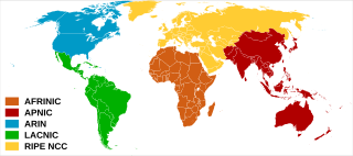
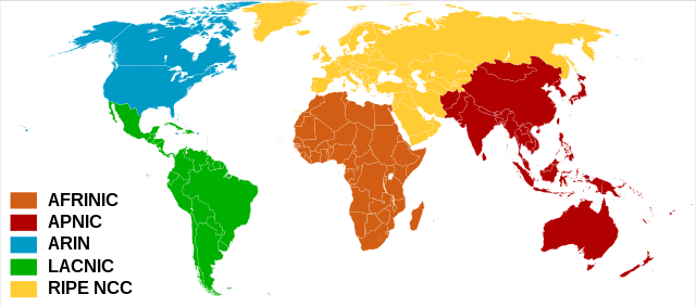
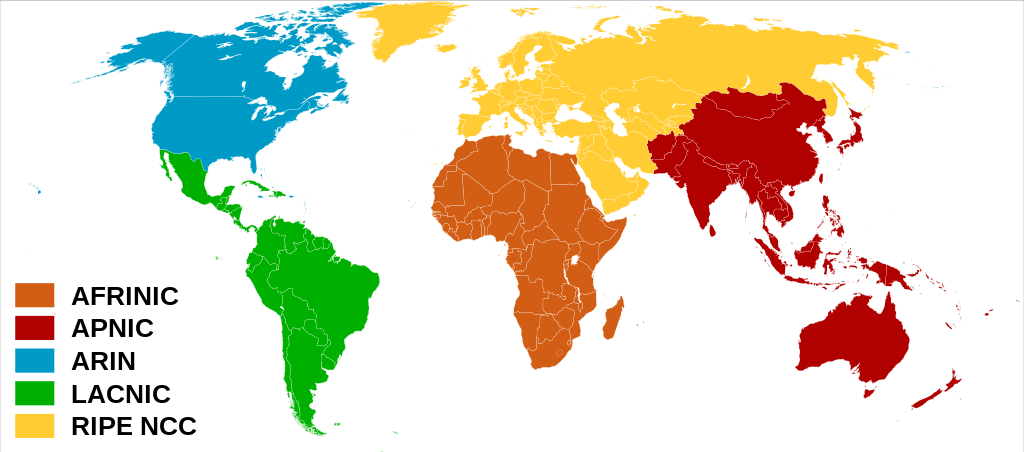
English: Regional Internet Registries world map.
Español: Mapa de Registros Regionales de Internet.
Français : Carte du monde des organisations de registre Internet régional. |
| 날짜 | (UTC) |
| 출처 | |
| 저자 | |
| 다른 버전 |
 |
라이선스
이 파일은 크리에이티브 커먼즈 저작자표시-동일조건변경허락 3.0 Unported 라이선스로 배포됩니다.
- 이용자는 다음의 권리를 갖습니다:
- 공유 및 이용 – 저작물의 복제, 배포, 전시, 공연 및 공중송신
- 재창작 – 저작물의 개작, 수정, 2차적저작물 창작
- 다음과 같은 조건을 따라야 합니다:
- 저작자표시 – 적절한 저작자 표시를 제공하고, 라이센스에 대한 링크를 제공하고, 변경사항이 있는지를 표시해야 합니다. 당신은 합리적인 방식으로 표시할 수 있지만, 어떤 방식으로든 사용권 허가자가 당신 또는 당신의 사용을 지지하는 방식으로 표시할 수 없습니다.
- 동일조건변경허락 – 만약 당신이 이 저작물을 리믹스 또는 변형하거나 이 저작물을 기반으로 제작하는 경우, 당신은 당신의 기여물을 원저작물과 동일하거나 호환 가능한 라이선스에 따라 배포하여야 합니다.
기존 올리기 기록
This image is a derivative work of the following images:
- File:Rir.gif licensed with Cc-by-sa-2.5, Cc-by-sa-2.5/en
- 2006-04-02T01:24:59Z Dork 300x163 (3093 Bytes) Regional Internet Registries (containing AFRINIC)
- File:BlankMap-World6,_compact.svg licensed with PD-self, PD-self/en
- 2008-12-02T18:21:18Z Lokal Profil 940x415 (1518276 Bytes) Reverted to version as of 14:51, 13 June 2008, new image has non of the complexity (i.e. colouring abilities etc.) of the old
- 2008-12-02T17:29:39Z Harbin 1326x601 (176022 Bytes)
- 2008-12-02T17:26:08Z Harbin 1425x625 (189017 Bytes)
- 2008-06-13T14:51:25Z Lokal Profil 940x415 (1518276 Bytes) Syncing with [[:Image:BlankMap-World6.svg]] version (01:30, March 29, 2008). Sadly enough the validator does not seem to like rdf element of the metadata although it should work acording to http://www.w3schools.com/rdf/rdf_ma
- 2008-02-08T20:55:35Z CarolSpears 940x415 (1528750 Bytes) validated, maybe
- 2007-12-14T19:51:17Z Lokal Profil 940x415 (1529675 Bytes) Readded an ocean object but this one is square instead of the original elliptic one
- 2007-12-14T19:19:56Z Lokal Profil 940x415 (1529845 Bytes) {{Information |Description=Detailed SVG map with grouping enabled to connect all non-contiguous parts of a country's territory for easy colouring. Smaller countries can also be represented by larger circles to show their data
Uploaded with derivativeFX
파일 역사
날짜/시간 링크를 클릭하면 해당 시간의 파일을 볼 수 있습니다.
| 날짜/시간 | 섬네일 | 크기 | 사용자 | 설명 | |
|---|---|---|---|---|---|
| 현재 | 2020년 2월 8일 (토) 17:57 | | 940 × 415 (1.48 MB) | Rauisuchian | Corrected name to AFRINIC, all capitalized |
| 2020년 2월 8일 (토) 17:18 |  | 940 × 415 (1.48 MB) | Rauisuchian | Change the ARIN and AFRINIC fill colors to those on their logos/websites. | |
| 2011년 6월 29일 (수) 04:59 |  | 940 × 415 (1.48 MB) | DOSGuy | Moved Dominica, Jamaica, Puerto Rico, Saint Lucia, Saint Vincent and the Grenadines from LACNIC to ARIN. Moved a number of Caribbean islands from RIPE to ARIN. Moved Fiji from RIPE to APNIC. Moved Falkland Islands from RIPE to LACNIC. | |
| 2010년 10월 17일 (일) 23:59 |  | 940 × 415 (1.48 MB) | Ben g | The less dominant texts were better | |
| 2009년 1월 29일 (목) 01:12 |  | 940 × 415 (1.48 MB) | Sémhur | Bigger texts | |
| 2009년 1월 28일 (수) 21:12 |  | 940 × 415 (1.48 MB) | Sémhur | {{Information |Description= {{en|Regional Internet Registries world map.}} {{fr|Carte du monde des organisations deregistre Internet régional.}} |Source= *File:Rir.gif *File:BlankMap-World6,_compact.svg |Da |
이 파일을 사용하는 문서
다음 문서 1개가 이 파일을 사용하고 있습니다:
이 파일을 사용하고 있는 모든 위키의 문서 목록
다음 위키에서 이 파일을 사용하고 있습니다:
- ar.wikipedia.org에서 이 파일을 사용하고 있는 문서 목록
- az.wikipedia.org에서 이 파일을 사용하고 있는 문서 목록
- be.wikipedia.org에서 이 파일을 사용하고 있는 문서 목록
- bn.wikipedia.org에서 이 파일을 사용하고 있는 문서 목록
- ca.wikipedia.org에서 이 파일을 사용하고 있는 문서 목록
- ckb.wikipedia.org에서 이 파일을 사용하고 있는 문서 목록
- de.wikipedia.org에서 이 파일을 사용하고 있는 문서 목록
- en.wikipedia.org에서 이 파일을 사용하고 있는 문서 목록
- eo.wikipedia.org에서 이 파일을 사용하고 있는 문서 목록
- es.wikipedia.org에서 이 파일을 사용하고 있는 문서 목록
- fr.wikipedia.org에서 이 파일을 사용하고 있는 문서 목록
- he.wikipedia.org에서 이 파일을 사용하고 있는 문서 목록
- hu.wikipedia.org에서 이 파일을 사용하고 있는 문서 목록
- ilo.wikipedia.org에서 이 파일을 사용하고 있는 문서 목록
- it.wikipedia.org에서 이 파일을 사용하고 있는 문서 목록
- ja.wikipedia.org에서 이 파일을 사용하고 있는 문서 목록
- la.wikipedia.org에서 이 파일을 사용하고 있는 문서 목록
- ml.wikipedia.org에서 이 파일을 사용하고 있는 문서 목록
- ms.wikipedia.org에서 이 파일을 사용하고 있는 문서 목록
- nl.wikipedia.org에서 이 파일을 사용하고 있는 문서 목록
- no.wikipedia.org에서 이 파일을 사용하고 있는 문서 목록
- pl.wikipedia.org에서 이 파일을 사용하고 있는 문서 목록
- pt.wikipedia.org에서 이 파일을 사용하고 있는 문서 목록
- ru.wikipedia.org에서 이 파일을 사용하고 있는 문서 목록
- sr.wikipedia.org에서 이 파일을 사용하고 있는 문서 목록
- sv.wikipedia.org에서 이 파일을 사용하고 있는 문서 목록
이 파일의 더 많은 사용 내역을 봅니다.