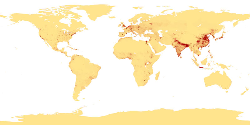
파일:Population density.png

미리 보기 크기: 800 × 400 픽셀 다른 해상도: 320 × 160 픽셀 | 640 × 320 픽셀 | 1,024 × 512 픽셀 | 1,280 × 640 픽셀 | 2,560 × 1,280 픽셀 | 4,320 × 2,160 픽셀
원본 파일 (4,320 × 2,160 픽셀, 파일 크기: 522 KB, MIME 종류: image/png)
파일 역사
날짜/시간 링크를 클릭하면 해당 시간의 파일을 볼 수 있습니다.
| 날짜/시간 | 섬네일 | 크기 | 사용자 | 설명 | |
|---|---|---|---|---|---|
| 현재 | 2013년 4월 11일 (목) 09:41 |  | 4,320 × 2,160 (522 KB) | Jahoe | Re-downloaded original from http://eoimages.gsfc.nasa.gov/images/imagerecords/53000/53005/population_density.tif, re-converted to PNG (preserving alpha channel) using tiff2png (by Willem van Schaik and Greg Roelofs). Removed rgb pixel values from fully... |
| 2007년 2월 27일 (화) 12:41 |  | 4,320 × 2,160 (915 KB) | Keenan Pepper | This image shows the number of people per square kilometer around the world in 1994. The data were derived from population records based on political divisions such as states, provinces, and counties. The image was taken from [http://visibleearth.nasa.go |
이 파일을 사용하는 문서
다음 문서 1개가 이 파일을 사용하고 있습니다:
이 파일을 사용하고 있는 모든 위키의 문서 목록
다음 위키에서 이 파일을 사용하고 있습니다:
- als.wikipedia.org에서 이 파일을 사용하고 있는 문서 목록
- an.wikipedia.org에서 이 파일을 사용하고 있는 문서 목록
- ar.wikipedia.org에서 이 파일을 사용하고 있는 문서 목록
- ast.wikipedia.org에서 이 파일을 사용하고 있는 문서 목록
- az.wikipedia.org에서 이 파일을 사용하고 있는 문서 목록
- be-tarask.wikipedia.org에서 이 파일을 사용하고 있는 문서 목록
- be.wikipedia.org에서 이 파일을 사용하고 있는 문서 목록
- bg.wikipedia.org에서 이 파일을 사용하고 있는 문서 목록
- bh.wikipedia.org에서 이 파일을 사용하고 있는 문서 목록
- bn.wikipedia.org에서 이 파일을 사용하고 있는 문서 목록
- bs.wikipedia.org에서 이 파일을 사용하고 있는 문서 목록
- ca.wikipedia.org에서 이 파일을 사용하고 있는 문서 목록
- ce.wikipedia.org에서 이 파일을 사용하고 있는 문서 목록
- ckb.wikipedia.org에서 이 파일을 사용하고 있는 문서 목록
- cu.wikipedia.org에서 이 파일을 사용하고 있는 문서 목록
- cv.wikipedia.org에서 이 파일을 사용하고 있는 문서 목록
- da.wikipedia.org에서 이 파일을 사용하고 있는 문서 목록
- da.wikibooks.org에서 이 파일을 사용하고 있는 문서 목록
- de.wikipedia.org에서 이 파일을 사용하고 있는 문서 목록
- dsb.wikipedia.org에서 이 파일을 사용하고 있는 문서 목록
- el.wikipedia.org에서 이 파일을 사용하고 있는 문서 목록
- en.wikipedia.org에서 이 파일을 사용하고 있는 문서 목록
- en.wikiquote.org에서 이 파일을 사용하고 있는 문서 목록
- eo.wikipedia.org에서 이 파일을 사용하고 있는 문서 목록
- es.wikipedia.org에서 이 파일을 사용하고 있는 문서 목록
이 파일의 더 많은 사용 내역을 봅니다.


