
파일:PonticKingdom.png

미리 보기 크기: 718 × 600 픽셀 다른 해상도: 287 × 240 픽셀 | 575 × 480 픽셀 | 919 × 768 픽셀 | 1,226 × 1,024 픽셀 | 1,551 × 1,296 픽셀
원본 파일 (1,551 × 1,296 픽셀, 파일 크기: 265 KB, MIME 종류: image/png)

|
이 그림 파일은 벡터 SVG 형식으로 다시 만들어야 합니다. SVG의 장점에 대해서는 여기(영어)를 참고해 주십시오. 만약 이 그림의 SVG 버전이 이미 존재한다면 이 틀을 {{vector version available|새 파일 이름.svg}}으로 대체해 주십시오.
|
| 설명 |
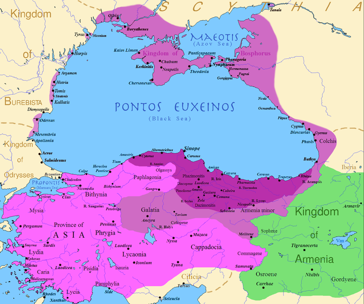
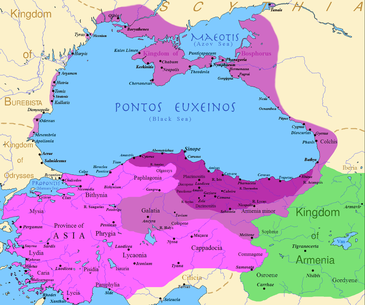
English: Map of the Kingdom of Pontus, Before the reign of Mithridates VI (darkest purple), after his conquests (purple), and his conquests in the first Mithridatic wars (pink); little adds (ancient shorelines & some greek colonies under Mithridate's rule) according with V. Yanko-Hombach, A.S. Gilbert, N. Panin, P. M. Dolukhanov: The Black Sea Flood Question: Changes in Coastline, Climate, and Human Settlement, Springer, Netherlands, 2007, and with Appianus, Plutarchus & Strabo. |
| 날짜 | |
| 출처 | I (Javierfv1212 (talk)) created this work entirely by myself. Sources, Cambridge Ancient history volume 9, Penguin atlas of Greek history and the Foreign Policy of Mithridates VI Eupator. |
| 저자 | Javierfv1212 (talk) |
라이선스
| 이 작품은 저작자인 영어 위키백과의 Javierfv1212에 의해 퍼블릭 도메인으로 공개된 작품입니다. 이 공개 선언은 전 세계적으로 유효합니다. 만약 저작권의 포기가 법률적으로 가능하지 않은 경우, Javierfv1212은 이 작품을 법적으로 허용되는 한도 내에서 누구나 자유롭게 어떤 목적으로도 제한 없이 사용할 수 있도록 허용합니다. |
기존 올리기 기록
Falcorian 사용자가 CommonsHelper 도구를 사용하여 en.wikipedia에서 공용으로 옮겨왔습니다.
The original description page was here. All following user names refer to en.wikipedia.
- 2009-07-19 23:42 Javierfv1212 1551×1296× (205182 bytes) {{Information |Description = Map of the Kingdom of Pontus, Before the reign of mithridates VI (darkest purple), after his conquests (purple), and his conquests in the first Mithridatic wars (pink). |Source = I (~~~) created this work entirel
파일 역사
날짜/시간 링크를 클릭하면 해당 시간의 파일을 볼 수 있습니다.
| 날짜/시간 | 섬네일 | 크기 | 사용자 | 설명 | |
|---|---|---|---|---|---|
| 현재 | 2017년 12월 9일 (토) 11:00 | | 1,551 × 1,296 (265 KB) | SteinsplitterBot | Bot: Image rotated by 90° |
| 2017년 12월 9일 (토) 09:00 |  | 1,296 × 1,551 (316 KB) | SteinsplitterBot | Bot: Image rotated by 270° | |
| 2016년 9월 23일 (금) 02:54 |  | 1,551 × 1,296 (265 KB) | Hohum | Lighten water area | |
| 2016년 8월 9일 (화) 20:21 |  | 1,551 × 1,296 (260 KB) | MAXHO | Details : more cities & shoreline of this time | |
| 2015년 10월 2일 (금) 05:57 |  | 1,551 × 1,296 (249 KB) | Spiridon Ion Cepleanu | Cosmetic again | |
| 2015년 9월 30일 (수) 21:55 |  | 1,551 × 1,296 (247 KB) | Spiridon Ion Cepleanu | Cosmetic colours & background names | |
| 2014년 4월 7일 (월) 23:21 |  | 1,551 × 1,296 (225 KB) | Spiridon Ion Cepleanu | Little changes (ancient shoreline & some greek colonies under Pontic rule) according with V. Yanko-Hombach, A.S. Gilbert, N. Panin, P. M. Dolukhanov: ''The Black Sea Flood Question: Changes in Coastline, Climate, and Human Settlement'', Springer, Nethe... | |
| 2009년 7월 20일 (월) 13:14 |  | 1,551 × 1,296 (200 KB) | File Upload Bot (Magnus Manske) | {{BotMoveToCommons|en.wikipedia|year={{subst:CURRENTYEAR}}|month={{subst:CURRENTMONTHNAME}}|day={{subst:CURRENTDAY}}}} {{Information |Description={{en|Map of the Kingdom of Pontus, Before the reign of mithridates VI (darkest purple), after his conquests |
이 파일을 사용하는 문서
다음 문서 1개가 이 파일을 사용하고 있습니다:
이 파일을 사용하고 있는 모든 위키의 문서 목록
다음 위키에서 이 파일을 사용하고 있습니다:
- ar.wikipedia.org에서 이 파일을 사용하고 있는 문서 목록
- ast.wikipedia.org에서 이 파일을 사용하고 있는 문서 목록
- azb.wikipedia.org에서 이 파일을 사용하고 있는 문서 목록
- az.wikipedia.org에서 이 파일을 사용하고 있는 문서 목록
- bg.wikipedia.org에서 이 파일을 사용하고 있는 문서 목록
- br.wikipedia.org에서 이 파일을 사용하고 있는 문서 목록
- ca.wikipedia.org에서 이 파일을 사용하고 있는 문서 목록
- cs.wikipedia.org에서 이 파일을 사용하고 있는 문서 목록
- da.wikipedia.org에서 이 파일을 사용하고 있는 문서 목록
- de.wikipedia.org에서 이 파일을 사용하고 있는 문서 목록
- el.wikipedia.org에서 이 파일을 사용하고 있는 문서 목록
- en.wikipedia.org에서 이 파일을 사용하고 있는 문서 목록
- es.wikipedia.org에서 이 파일을 사용하고 있는 문서 목록
- et.wikipedia.org에서 이 파일을 사용하고 있는 문서 목록
- eu.wikipedia.org에서 이 파일을 사용하고 있는 문서 목록
- fa.wikipedia.org에서 이 파일을 사용하고 있는 문서 목록
- fr.wikipedia.org에서 이 파일을 사용하고 있는 문서 목록
이 파일의 더 많은 사용 내역을 봅니다.