
파일:Philippines.A2002088.0220.1km.jpg

원본 파일 (1,150 × 1,500 픽셀, 파일 크기: 417 KB, MIME 종류: image/jpeg)
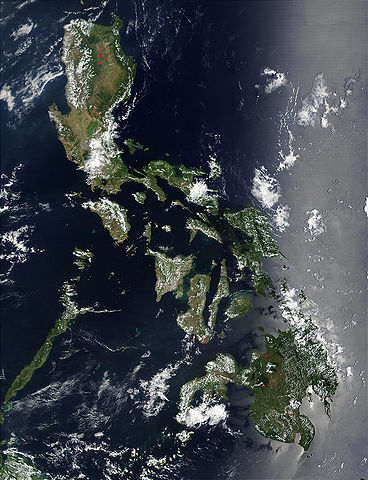
Credit: Jacques Descloitres, MODIS Land Rapid Response Team, NASA/GSFC
Red dots (or outlines in the high-resolution imagery) indicate MODIS9 detection of thermal anomalies throughout the Philippines on March 29, 2002. In most cases, the anomaly is a fire, for example, all the locations marked on the northernmost island, Luzon. However, south of center, on the southern tip of Negros, the thermal anomaly is likely volcanic activity, and the red dot left of center of the main part of Mindanao (lower right) marks the location of a volcano called Mount Ragang.
http://visibleearth.nasa.gov/view_rec.php?id=2656
| 이 파일은 NASA에서 제작하였으므로 퍼블릭 도메인입니다. NASA의 저작권 정책에 따르면 NASA의 자료는 명시하지 않는 이상 저작권의 보호를 받지 않습니다. (Template:PD-USGov, 또는 NASA 저작권 정책 문서, JPL 그림 사용 정책을 참고하세요.) | ||
 |
주의사항:
|
파일 역사
날짜/시간 링크를 클릭하면 해당 시간의 파일을 볼 수 있습니다.
| 날짜/시간 | 섬네일 | 크기 | 사용자 | 설명 | |
|---|---|---|---|---|---|
| 현재 | 2005년 10월 26일 (수) 06:55 | | 1,150 × 1,500 (417 KB) | Brian0918 | Credit: Jacques Descloitres, MODIS Land Rapid Response Team, NASA/GSFC Red dots (or outlines in the high-resolution imagery) indicate MODIS9 detection of thermal anomalies throughout the Philippines on March 29, 2002. In most cases, the anomaly is a fire |
이 파일을 사용하는 문서
다음 문서 1개가 이 파일을 사용하고 있습니다:
이 파일을 사용하고 있는 모든 위키의 문서 목록
다음 위키에서 이 파일을 사용하고 있습니다:
- af.wikipedia.org에서 이 파일을 사용하고 있는 문서 목록
- ar.wikipedia.org에서 이 파일을 사용하고 있는 문서 목록
- ast.wikipedia.org에서 이 파일을 사용하고 있는 문서 목록
- de.wikipedia.org에서 이 파일을 사용하고 있는 문서 목록
- en.wikipedia.org에서 이 파일을 사용하고 있는 문서 목록
- es.wikipedia.org에서 이 파일을 사용하고 있는 문서 목록
- es.wiktionary.org에서 이 파일을 사용하고 있는 문서 목록
- fr.wikipedia.org에서 이 파일을 사용하고 있는 문서 목록
- hr.wikipedia.org에서 이 파일을 사용하고 있는 문서 목록
- ilo.wikipedia.org에서 이 파일을 사용하고 있는 문서 목록
- it.wikipedia.org에서 이 파일을 사용하고 있는 문서 목록
- km.wikipedia.org에서 이 파일을 사용하고 있는 문서 목록
- nl.wikipedia.org에서 이 파일을 사용하고 있는 문서 목록
- pl.wikipedia.org에서 이 파일을 사용하고 있는 문서 목록
- pl.wikinews.org에서 이 파일을 사용하고 있는 문서 목록
- pt.wikipedia.org에서 이 파일을 사용하고 있는 문서 목록
- sh.wikipedia.org에서 이 파일을 사용하고 있는 문서 목록
- sq.wikipedia.org에서 이 파일을 사용하고 있는 문서 목록
- tl.wikipedia.org에서 이 파일을 사용하고 있는 문서 목록
- uk.wikipedia.org에서 이 파일을 사용하고 있는 문서 목록