
파일:Pan-European corridors.svg

SVG 파일의 PNG 형식의 미리보기 크기: 392 × 486 픽셀. 다른 해상도: 193 × 240 픽셀 | 387 × 480 픽셀 | 619 × 768 픽셀 | 826 × 1,024 픽셀 | 1,652 × 2,048 픽셀
원본 파일 (SVG 파일, 실제 크기 392 × 486 픽셀, 파일 크기: 561 KB)
파일 설명
| 설명 |
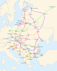
English: Map of the ten Pan-European transport corridors. |
| 날짜 | (UTC) |
| 출처 | |
| 저자 |
|
| 다른 버전 |
|
| SVG 발전 |


라이선스
이 파일은 크리에이티브 커먼즈 저작자표시-동일조건변경허락 3.0 Unported 라이선스로 배포됩니다.
- 이용자는 다음의 권리를 갖습니다:
- 공유 및 이용 – 저작물의 복제, 배포, 전시, 공연 및 공중송신
- 재창작 – 저작물의 개작, 수정, 2차적저작물 창작
- 다음과 같은 조건을 따라야 합니다:
- 저작자표시 – 적절한 저작자 표시를 제공하고, 라이센스에 대한 링크를 제공하고, 변경사항이 있는지를 표시해야 합니다. 당신은 합리적인 방식으로 표시할 수 있지만, 어떤 방식으로든 사용권 허가자가 당신 또는 당신의 사용을 지지하는 방식으로 표시할 수 없습니다.
- 동일조건변경허락 – 만약 당신이 이 저작물을 리믹스 또는 변형하거나 이 저작물을 기반으로 제작하는 경우, 당신은 당신의 기여물을 원저작물과 동일하거나 호환 가능한 라이선스에 따라 배포하여야 합니다.
기존 올리기 기록
This image is a derivative work of the following images:
- File:Blank_map_of_Europe_-_Atelier_graphique_colors.svg licensed with Cc-by-sa-2.5,2.0,1.0, Cc-by-sa-2.5,2.0,1.0/en, GFDL, GFDL/en
- 2008-09-23T18:46:08Z Antigoni 841x731 (498781 Bytes) Montenegro update
- 2007-09-16T15:08:27Z Historicair 841x731 (495651 Bytes)
- 2007-09-13T16:36:42Z Historicair 841x731 (495370 Bytes) {{Information |Description={{fr|Carte vierge de l'Europe, couleurs Atelier Graphique}} {{en|Blank map of Europe with Atelier graphique colors}} |Source=[[:Image:Europe countries.svg]] by [[User:Tintazul|Tintazul]] |Date=13/09
- File:Paneuropetransport.png licensed with PD-self, PD-self/en
- 2007-10-18T08:05:36Z Hoshie 773x942 (45202 Bytes) added Montenegro. Under same lic. as before.
- 2006-12-12T23:11:56Z Albinfo 773x942 (37476 Bytes) Fixed several errors and updated corrections in the original file - sorry for all the misleadings
- 2006-12-05T20:06:34Z Geo-Loge 773x941 (33896 Bytes) Ostrava => Brno, Ostrava added, Wroclaw and Krakow added
- 2006-06-24T17:12:35Z Joy 773x941 (28882 Bytes) Fixed confusion between Lviv and Uzhorod.
- 2005-12-30T22:42:00Z Albinfo 773x941 (37167 Bytes) The ten Pan-European transport corridors. Created by [[User:Albinfo]] using [[User:wiki-vr]]'s [[:Image:Europe_blank_map.png|blank map]].
Uploaded with derivativeFX
파일 역사
날짜/시간 링크를 클릭하면 해당 시간의 파일을 볼 수 있습니다.
| 날짜/시간 | 섬네일 | 크기 | 사용자 | 설명 | |
|---|---|---|---|---|---|
| 현재 | 2018년 2월 26일 (월) 06:16 | | 392 × 486 (561 KB) | Nameless23 | Fixed the spelling of Kaliningrad and Nizhny Novgorod. |
| 2009년 11월 4일 (수) 08:55 |  | 392 × 486 (561 KB) | Joy | {{Information |Description={{en|Map of the ten Pan-European transport corridors.}} |Source=*File:Pan-European_corridors.svg |Date=2009-11-03 23:54 (UTC) |Author=*File:Pan-European_corridors.svg: *[[:File:Blank_map_of_Europe_-_Atelier_graphique | |
| 2009년 2월 4일 (수) 08:46 |  | 392 × 486 (554 KB) | Honza.havlicek | {{Information |Description={{en|Map of the ten Pan-European transport corridors.}} |Source=*File:Blank_map_of_Europe_-_Atelier_graphique_colors.svg *File:Paneuropetransport.png |Date=2009-02-03 23:39 (UTC) |Author=*[[:File:Blank_map_of_Europe_ |
이 파일을 사용하는 문서
다음 문서 1개가 이 파일을 사용하고 있습니다:
이 파일을 사용하고 있는 모든 위키의 문서 목록
다음 위키에서 이 파일을 사용하고 있습니다:
- ar.wikipedia.org에서 이 파일을 사용하고 있는 문서 목록
- bg.wikipedia.org에서 이 파일을 사용하고 있는 문서 목록
- bs.wikipedia.org에서 이 파일을 사용하고 있는 문서 목록
- en.wikipedia.org에서 이 파일을 사용하고 있는 문서 목록
- fr.wikipedia.org에서 이 파일을 사용하고 있는 문서 목록
- he.wikipedia.org에서 이 파일을 사용하고 있는 문서 목록
- hr.wikipedia.org에서 이 파일을 사용하고 있는 문서 목록
- hu.wikipedia.org에서 이 파일을 사용하고 있는 문서 목록
- id.wikipedia.org에서 이 파일을 사용하고 있는 문서 목록
- it.wikipedia.org에서 이 파일을 사용하고 있는 문서 목록
- ja.wikipedia.org에서 이 파일을 사용하고 있는 문서 목록
- nl.wikipedia.org에서 이 파일을 사용하고 있는 문서 목록
- no.wikipedia.org에서 이 파일을 사용하고 있는 문서 목록
- pl.wikipedia.org에서 이 파일을 사용하고 있는 문서 목록
- ro.wikipedia.org에서 이 파일을 사용하고 있는 문서 목록
- ru.wikipedia.org에서 이 파일을 사용하고 있는 문서 목록
- sk.wikipedia.org에서 이 파일을 사용하고 있는 문서 목록
- sl.wikipedia.org에서 이 파일을 사용하고 있는 문서 목록
- sq.wikipedia.org에서 이 파일을 사용하고 있는 문서 목록
- uk.wikipedia.org에서 이 파일을 사용하고 있는 문서 목록
- www.wikidata.org에서 이 파일을 사용하고 있는 문서 목록