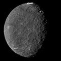
파일:PIA00040 Umbrielx2.47.jpg

미리 보기 크기: 600 × 600 픽셀 다른 해상도: 240 × 240 픽셀 | 620 × 620 픽셀
원본 파일 (620 × 620 픽셀, 파일 크기: 66 KB, MIME 종류: image/jpeg)
파일 역사
날짜/시간 링크를 클릭하면 해당 시간의 파일을 볼 수 있습니다.
| 날짜/시간 | 섬네일 | 크기 | 사용자 | 설명 | |
|---|---|---|---|---|---|
| 현재 | 2022년 12월 2일 (금) 08:36 |  | 620 × 620 (66 KB) | Nrco0e | This is inappropriate enhancing of real data. AI upscaling or whatever enhancing process you use to bring out inordinate amounts of (likely fictitious) detail should not be used on real astronomical imagery, and is not in the educational scope of Commons and Wikipedia. Reverted to version as of 07:23, 25 September 2018 (UTC) |
| 2022년 10월 1일 (토) 03:27 |  | 616 × 616 (95 KB) | Italyoz484 | m | |
| 2022년 10월 1일 (토) 03:26 |  | 616 × 616 (100 KB) | Italyoz484 | Grayscale removed | |
| 2018년 9월 25일 (화) 16:23 |  | 620 × 620 (66 KB) | PlanetUser | Frame | |
| 2015년 11월 19일 (목) 17:52 |  | 586 × 586 (94 KB) | PlanetUser | Cropped 7 % horizontally and 7 % vertically using CropTool with precise mode. | |
| 2011년 4월 3일 (일) 15:25 |  | 628 × 628 (95 KB) | WolfmanSF | A bit more cropping | |
| 2011년 4월 3일 (일) 15:05 |  | 660 × 660 (96 KB) | WolfmanSF | Further cropping | |
| 2011년 4월 3일 (일) 14:50 |  | 740 × 740 (98 KB) | WolfmanSF | {{Information |Description ={{en|1=The southern hemisphere of Umbriel displays heavy cratering in this Voyager 2 image, taken Jan. 24, 1986, from a distance of 557,000 kilometers (346,000 miles). This frame, taken through the clear-filter of Voyager's |
이 파일을 사용하는 문서
다음 문서 6개가 이 파일을 사용하고 있습니다:
이 파일을 사용하고 있는 모든 위키의 문서 목록
다음 위키에서 이 파일을 사용하고 있습니다:
- af.wikipedia.org에서 이 파일을 사용하고 있는 문서 목록
- an.wikipedia.org에서 이 파일을 사용하고 있는 문서 목록
- ar.wikipedia.org에서 이 파일을 사용하고 있는 문서 목록
- ary.wikipedia.org에서 이 파일을 사용하고 있는 문서 목록
- arz.wikipedia.org에서 이 파일을 사용하고 있는 문서 목록
- ast.wikipedia.org에서 이 파일을 사용하고 있는 문서 목록
- as.wikipedia.org에서 이 파일을 사용하고 있는 문서 목록
- azb.wikipedia.org에서 이 파일을 사용하고 있는 문서 목록
- be.wikipedia.org에서 이 파일을 사용하고 있는 문서 목록
- bh.wikipedia.org에서 이 파일을 사용하고 있는 문서 목록
- bn.wikibooks.org에서 이 파일을 사용하고 있는 문서 목록
- ca.wikipedia.org에서 이 파일을 사용하고 있는 문서 목록
- ceb.wikipedia.org에서 이 파일을 사용하고 있는 문서 목록
- ckb.wikipedia.org에서 이 파일을 사용하고 있는 문서 목록
- el.wikipedia.org에서 이 파일을 사용하고 있는 문서 목록
- en.wikipedia.org에서 이 파일을 사용하고 있는 문서 목록
- Umbriel (moon)
- Voyager 2
- Icy moon
- Timeline of discovery of Solar System planets and their moons
- List of Solar System objects by size
- Moons of Uranus
- Naming of moons
- List of natural satellites
- Portal:Astronomy/Featured
- List of gravitationally rounded objects of the Solar System
- User:Ignitus/Sandbox
- User:Kwamikagami/sandbox
- Planetary-mass moon
- User talk:Ruslik0/Archive 8
- Wikipedia:Today's featured article/April 2011
- Wikipedia:Today's featured article/April 3, 2011
- Wikipedia:Main Page history/2011 April 3
- Portal:Astronomy/Featured/5
- User talk:71.8.121.8/Pictures of the Day
이 파일의 더 많은 사용 내역을 봅니다.


