
파일:ORD Airport Diagram.svg

SVG 파일의 PNG 형식의 미리보기 크기: 390 × 599 픽셀. 다른 해상도: 156 × 240 픽셀 | 313 × 480 픽셀 | 500 × 768 픽셀 | 667 × 1,024 픽셀 | 1,334 × 2,048 픽셀 | 484 × 743 픽셀
원본 파일 (SVG 파일, 실제 크기 484 × 743 픽셀, 파일 크기: 3.46 MB)
파일 설명
| 설명 |
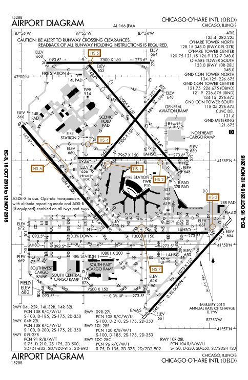
English: FAA Airport Diagram of O'Hare International Airport. |
| 날짜 | |
| 출처 |
FAA Airport Diagrams; note that these change every 28 days. Taken from PDF on FAA site and converted to SVG using en:Wikipedia:How to draw SVG circuits using Xcircuit. |
| 저자 | Produced by the National Aeronautical Charting Office (NACO), a department of the United States en:Federal Aviation Administration. |
| 카메라 위치 | | 이 지역의 다른 사진을 보기: OpenStreetMap |
|---|
W3C-validity not checked.
라이선스
This image or file is a work of a Federal Aviation Administration employee, taken or made as part of that person's official duties. As a work of the U.S. federal government, the image is in the public domain in the United States.
|
 |
파일 역사
날짜/시간 링크를 클릭하면 해당 시간의 파일을 볼 수 있습니다.
| 날짜/시간 | 섬네일 | 크기 | 사용자 | 설명 | |
|---|---|---|---|---|---|
| 현재 | 2015년 10월 16일 (금) 06:27 | | 484 × 743 (3.46 MB) | BorgHunter | New diagram with 10R/28L |
| 2014년 11월 8일 (토) 23:36 |  | 484 × 743 (1.63 MB) | BorgHunter | Updated diagram includes runway 28C | |
| 2013년 5월 2일 (목) 23:02 |  | 378 × 547 (1.62 MB) | Grendelkhan | SVG version of FAA's PDF diagram. |
이 파일을 사용하는 문서
다음 문서 1개가 이 파일을 사용하고 있습니다:
이 파일을 사용하고 있는 모든 위키의 문서 목록
다음 위키에서 이 파일을 사용하고 있습니다:
- ar.wikipedia.org에서 이 파일을 사용하고 있는 문서 목록
- de.wikipedia.org에서 이 파일을 사용하고 있는 문서 목록
- en.wikipedia.org에서 이 파일을 사용하고 있는 문서 목록
- eo.wikipedia.org에서 이 파일을 사용하고 있는 문서 목록
- fr.wikipedia.org에서 이 파일을 사용하고 있는 문서 목록
- hi.wikipedia.org에서 이 파일을 사용하고 있는 문서 목록
- it.wikipedia.org에서 이 파일을 사용하고 있는 문서 목록
- ja.wikipedia.org에서 이 파일을 사용하고 있는 문서 목록
- pl.wikipedia.org에서 이 파일을 사용하고 있는 문서 목록
- ru.wikipedia.org에서 이 파일을 사용하고 있는 문서 목록
- sk.wikipedia.org에서 이 파일을 사용하고 있는 문서 목록
- sl.wikipedia.org에서 이 파일을 사용하고 있는 문서 목록
- th.wikipedia.org에서 이 파일을 사용하고 있는 문서 목록
- www.wikidata.org에서 이 파일을 사용하고 있는 문서 목록