
파일:North Yorkshire UK location map (1974-2023).svg

SVG 파일의 PNG 형식의 미리보기 크기: 800 × 582 픽셀. 다른 해상도: 320 × 233 픽셀 | 640 × 466 픽셀 | 1,024 × 745 픽셀 | 1,280 × 931 픽셀 | 2,560 × 1,863 픽셀 | 1,425 × 1,037 픽셀
원본 파일 (SVG 파일, 실제 크기 1,425 × 1,037 픽셀, 파일 크기: 3.22 MB)
.svg?uselang=ko)
| 설명 |
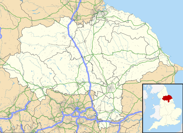
Map of North Yorkshire, UK with the following information shown:
Equirectangular map projection on WGS 84 datum, with N/S stretched 170% Geographic limits:
|
| 날짜 | |
| 출처 |
|
| 저자 | Nilfanion, created using Ordnance Survey data |
| 저작권 (이 파일을 인용하기) |
이 파일은 크리에이티브 커먼즈 저작자표시-동일조건변경허락 3.0 Unported 라이선스로 배포됩니다. 저작자표시: Contains Ordnance Survey data © Crown copyright and database right
|
| 다른 버전 | File:North Yorkshire UK district map (blank).svg - Blank map |
.svg)
파일 역사
날짜/시간 링크를 클릭하면 해당 시간의 파일을 볼 수 있습니다.
| 날짜/시간 | 섬네일 | 크기 | 사용자 | 설명 | |
|---|---|---|---|---|---|
| 현재 | 2018년 4월 2일 (월) 05:34 | | 1,425 × 1,037 (3.22 MB) | Nilfanion | Update to A1 -> A1(M), other tweaks |
| 2010년 9월 27일 (월) 04:07 |  | 1,425 × 1,037 (3.17 MB) | Nilfanion | {{Information |Description=Map of North Yorkshire, UK with the following information shown: *Administrative borders *Coastline, lakes and rivers *Roads and railways *Urban areas Equirectangular map projection on WGS 84 datum, with N |
이 파일을 사용하는 문서
다음 문서 1개가 이 파일을 사용하고 있습니다:
이 파일을 사용하고 있는 모든 위키의 문서 목록
다음 위키에서 이 파일을 사용하고 있습니다:
- ar.wikipedia.org에서 이 파일을 사용하고 있는 문서 목록
- bg.wikipedia.org에서 이 파일을 사용하고 있는 문서 목록
- ceb.wikipedia.org에서 이 파일을 사용하고 있는 문서 목록
- da.wikipedia.org에서 이 파일을 사용하고 있는 문서 목록
- en.wikipedia.org에서 이 파일을 사용하고 있는 문서 목록
- es.wikipedia.org에서 이 파일을 사용하고 있는 문서 목록
- York
- Castillo de Howard
- Scarborough
- Ripon
- Middlesbrough
- RAF Fylingdales
- Catedral de York
- Museo de Yorkshire
- Stainforth (Yorkshire del Norte)
- Harrogate
- Plantilla:Mapa de localización de Yorkshire del Norte
- Fulford (Yorkshire del Norte)
- Tunstall (Yorkshire del Norte)
- Abadía de Whitby
- Barlby
- Appletreewick
- Skipton
- Selby
- Northallerton
- Glaisdale
- Cross Hills
- Colburn (Yorkshire del Norte)
- Ampleforth
- Alne
- Cononley
- Cowling
- Appleton Roebuck
- Darley
- Alanbrooke Barracks
- Monk Fryston
- Helperby
- High Bentham
- Hemingbrough
- Austwick
- Embsay
- East Cowton
- Easingwold
- Eggborough
- Escrick
- Bagby
- Hensall
- Hinderwell
- Sheriff Hutton
- Shipton (Yorkshire del Norte)
이 파일의 더 많은 사용 내역을 봅니다.
.svg)
.svg)