
파일:Noahsworld map.png

미리 보기 크기: 402 × 599 픽셀 다른 해상도: 161 × 240 픽셀 | 322 × 480 픽셀
원본 파일 (800 × 1,192 픽셀, 파일 크기: 337 KB, MIME 종류: image/png)
| 설명 |
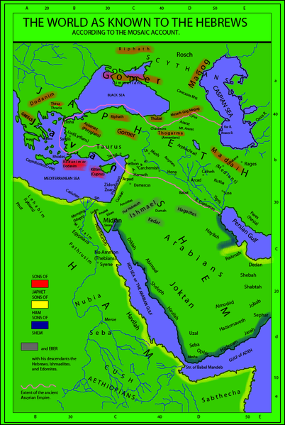
English: The world as known to the Hebrews. A map from "Historical Textbook and Atlas of Biblical Geography (1854)" by Lyman Coleman |
||||||||||||||
| 날짜 | |||||||||||||||
| 출처 |
|
||||||||||||||
| 저자 |
|
||||||||||||||
| 저작권 (이 파일을 인용하기) |
|
||||||||||||||
| 다른 버전 |
This map derives from a 1854 map   |
||||||||||||||
_(14793127233)_(cropped).jpg)
파일 역사
날짜/시간 링크를 클릭하면 해당 시간의 파일을 볼 수 있습니다.
| 날짜/시간 | 섬네일 | 크기 | 사용자 | 설명 | |
|---|---|---|---|---|---|
| 현재 | 2010년 2월 20일 (토) 05:18 | | 800 × 1,192 (337 KB) | Megistias | Added, Zidon, Zoar, Arpad, Aram, Arphachsad, Mash, Carchemish, Calneh, (Armenians) parentheses in Medians. Ludim, Amalek, Edom, Midian and Sinim. Kaspian, Kur R., |
| 2010년 2월 19일 (금) 23:40 |  | 800 × 1,192 (331 KB) | Megistias | {{Information |Description={{en|The World as known to the Hebrews. A map from Historical Textbook and Atlas of Biblical Geography (1854) by Coleman}} |Source= *map from Historical Textbook and Atlas of Biblical Geography (1854) by Coleman *Historical Orig |
이 파일을 사용하는 문서
다음 문서 1개가 이 파일을 사용하고 있습니다:
이 파일을 사용하고 있는 모든 위키의 문서 목록
다음 위키에서 이 파일을 사용하고 있습니다:
- bo.wikipedia.org에서 이 파일을 사용하고 있는 문서 목록
- en.wikipedia.org에서 이 파일을 사용하고 있는 문서 목록