
파일:Mecklenburg-Vorpommern Map Districts Border Mecklenburg Western Pomerania - Landkreise Grenzen Karte MV MeckPomm.svg

SVG 파일의 PNG 형식의 미리보기 크기: 800 × 549 픽셀. 다른 해상도: 320 × 220 픽셀 | 640 × 439 픽셀 | 1,024 × 703 픽셀 | 1,280 × 879 픽셀 | 2,560 × 1,757 픽셀 | 1,129 × 775 픽셀
원본 파일 (SVG 파일, 실제 크기 1,129 × 775 픽셀, 파일 크기: 759 KB)
파일 설명
| 설명 |
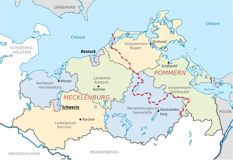
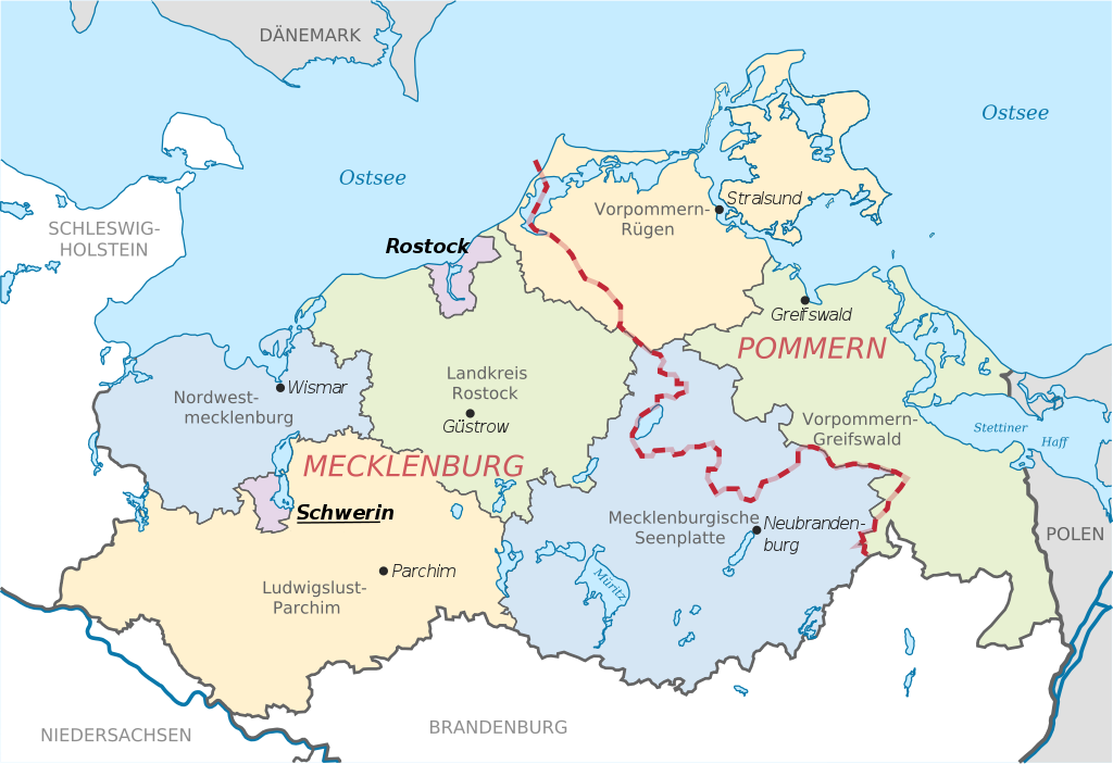
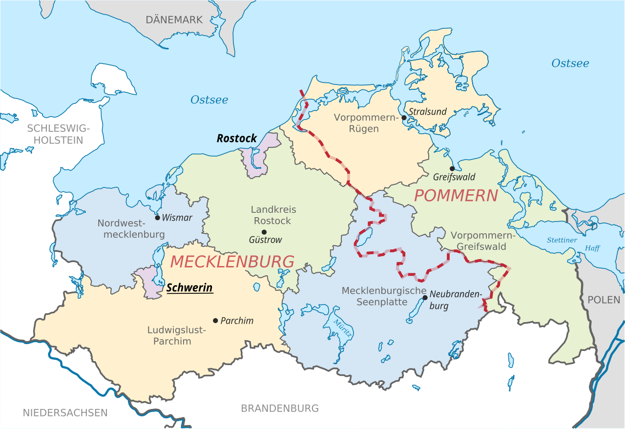
English: Locator map of counties and their seats in Mecklenburg-Vorpommern, Germany after county reorganization 2011. The red-white line indicates the former border between the state of Mecklenburg and the Prussian province of Pommerania.
Deutsch: Karte mit Lage der Landkreise und Kreisstädte in Mecklenburg-Vorpommern, Deutschland nach der Kreisgebietsreform 2011. Eingezeichnet ist auch die Grenze zwischen dem früheren Staat Mecklenburg und der preußischen Provinz Pommern. |
| 날짜 | |
| 출처 | File:Mecklenburg-Vorpommern districts 2011 colored labeled Meck-Pomm-border.svg |
| 저자 | TUBS |
| 다른 버전 |
|


라이선스
| 이 작품은 저작자인 TUBS에 의해 퍼블릭 도메인으로 공개된 작품입니다. 이 공개 선언은 전 세계적으로 유효합니다. 만약 저작권의 포기가 법률적으로 가능하지 않은 경우, |
파일 역사
날짜/시간 링크를 클릭하면 해당 시간의 파일을 볼 수 있습니다.
| 날짜/시간 | 섬네일 | 크기 | 사용자 | 설명 | |
|---|---|---|---|---|---|
| 현재 | 2014년 6월 16일 (월) 20:51 | | 1,129 × 775 (759 KB) | Horst-schlaemma | {{Information |Description ={{en|1=Locator map of counties and their seats in Mecklenburg-Vorpommern, Germany after county reorganization 2011. The red-white line indicates the former borders of the his... |
이 파일을 사용하는 문서
다음 문서 1개가 이 파일을 사용하고 있습니다:
이 파일을 사용하고 있는 모든 위키의 문서 목록
다음 위키에서 이 파일을 사용하고 있습니다:
- af.wikipedia.org에서 이 파일을 사용하고 있는 문서 목록
- als.wikipedia.org에서 이 파일을 사용하고 있는 문서 목록
- an.wikipedia.org에서 이 파일을 사용하고 있는 문서 목록
- ast.wikipedia.org에서 이 파일을 사용하고 있는 문서 목록
- ay.wikipedia.org에서 이 파일을 사용하고 있는 문서 목록
- az.wikipedia.org에서 이 파일을 사용하고 있는 문서 목록
- ba.wikipedia.org에서 이 파일을 사용하고 있는 문서 목록
- be-tarask.wikipedia.org에서 이 파일을 사용하고 있는 문서 목록
- bg.wikipedia.org에서 이 파일을 사용하고 있는 문서 목록
- br.wikipedia.org에서 이 파일을 사용하고 있는 문서 목록
- ca.wikipedia.org에서 이 파일을 사용하고 있는 문서 목록
- csb.wikipedia.org에서 이 파일을 사용하고 있는 문서 목록
- cs.wikipedia.org에서 이 파일을 사용하고 있는 문서 목록
- cy.wikipedia.org에서 이 파일을 사용하고 있는 문서 목록
- de.wikipedia.org에서 이 파일을 사용하고 있는 문서 목록
- de.wikivoyage.org에서 이 파일을 사용하고 있는 문서 목록
- dsb.wikipedia.org에서 이 파일을 사용하고 있는 문서 목록
- en.wikipedia.org에서 이 파일을 사용하고 있는 문서 목록
- eo.wikipedia.org에서 이 파일을 사용하고 있는 문서 목록
- es.wikipedia.org에서 이 파일을 사용하고 있는 문서 목록
- et.wikipedia.org에서 이 파일을 사용하고 있는 문서 목록
- eu.wikipedia.org에서 이 파일을 사용하고 있는 문서 목록
- fi.wikipedia.org에서 이 파일을 사용하고 있는 문서 목록
- frr.wikipedia.org에서 이 파일을 사용하고 있는 문서 목록
- fr.wikipedia.org에서 이 파일을 사용하고 있는 문서 목록
- fy.wikipedia.org에서 이 파일을 사용하고 있는 문서 목록
- ga.wikipedia.org에서 이 파일을 사용하고 있는 문서 목록
- gd.wikipedia.org에서 이 파일을 사용하고 있는 문서 목록
- gl.wikipedia.org에서 이 파일을 사용하고 있는 문서 목록
- gn.wikipedia.org에서 이 파일을 사용하고 있는 문서 목록
- gv.wikipedia.org에서 이 파일을 사용하고 있는 문서 목록
- he.wikipedia.org에서 이 파일을 사용하고 있는 문서 목록
- hr.wikipedia.org에서 이 파일을 사용하고 있는 문서 목록
- hsb.wikipedia.org에서 이 파일을 사용하고 있는 문서 목록
- hu.wikipedia.org에서 이 파일을 사용하고 있는 문서 목록
- hu.wiktionary.org에서 이 파일을 사용하고 있는 문서 목록
- ia.wikipedia.org에서 이 파일을 사용하고 있는 문서 목록
- id.wikipedia.org에서 이 파일을 사용하고 있는 문서 목록
이 파일의 더 많은 사용 내역을 봅니다.