파일:Mars Map.JPG

문서 내용이 다른 언어로는 지원되지 않습니다.
위키백과, 우리 모두의 백과사전.

원본 파일(2,180 × 1,244 픽셀, 파일 크기: 2.33 MB, MIME 종류: image/jpeg)

파일 설명

설명
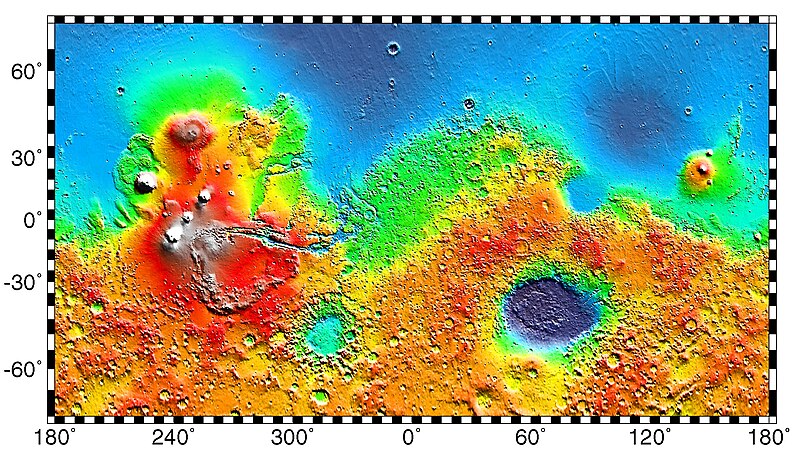
English: PIA02031: Maps of Mars Global Topography - Maps of Mars' global topography. The projections are Mercator to 70° latitude and stereographic at the poles with the south pole at left and north pole at right. Note the elevation difference between the northern and southern hemispheres. The Tharsis volcano-tectonic province is centered near the equator in the longitude range 220° E to 300° E and contains the vast east-west trending Valles Marineris canyon system and several major volcanic shields including Olympus Mons (18° N, 225° E), Alba Patera (42° N, 252° E), Ascraeus Mons (12° N, 248° E), Pavonis Mons (0°, 247° E), and Arsia Mons (9° S, 239° E). Regions and structures discussed in the text include Solis Planum (25° S, 270° E), Lunae Planum (10° N, 290° E), and Claritas Fossae (30° S, 255° E). Major impact basins include Hellas (45° S, 70° E), Argyre (50° S, 320° E), Isidis (12° N, 88° E), and Utopia (45° N, 110° E). This analysis uses an areocentric coordinate convention with east longitude positive.

Color coding on this map of the planet Mars indicates relative elevations based on data from the Mars Orbiter Laser Altimeter on NASA's Mars Global Surveyor. Red is higher elevation (up to +8 km and higher); yellow is 0 km; blue is lower elevation (down to -8 km). In longitude, the map extends from 70 degrees (north) to minus 70 degrees (south). The east-west axis is labeled at the bottom in degrees of east longitude, with the zero meridian at the center.

Data was produced by the Mars Global Surveyor's MOLA instrument

  • Producer ID: P50409 MRPS95009
Português: Mapa de Marte.
Русский: Карта Марса.
날짜 (released)
출처 http://photojournal.jpl.nasa.gov/catalog/PIA02031 (image link)
저자 NASA/JPL/GSFC
저작권
(이 파일을 인용하기)
https://www.jpl.nasa.gov/imagepolicy/
다른 버전

Related Templates:

Related Images:

This image or video was catalogued by Jet Propulsion Laboratory of the United States National Aeronautics and Space Administration (NASA) under Photo ID: PIA02031.

This tag does not indicate the copyright status of the attached work. A normal copyright tag is still required. See Commons:Licensing.
Other languages:

라이선스

Public domain 이 파일은 NASA에서 제작하였으므로 퍼블릭 도메인입니다. NASA의 저작권 정책에 따르면 NASA의 자료는 명시하지 않는 이상 저작권의 보호를 받지 않습니다. (Template:PD-USGov, 또는 NASA 저작권 정책 문서, JPL 그림 사용 정책을 참고하세요.)
주의사항:

기존 올리기 기록

The original description page was here. All following user names refer to en.wikipedia.
  • 2012-10-26 05:43 Kelvin Case 613×350× (142399 bytes) {{Information |Description= {{en|Map of mars.}} {{pt|Mapa de Marte.}} http://photojournal.jpl.nasa.gov/catalog/PIA02031 PIA02031: Maps of Mars Global Topography Target Name:Mars Is a satellite of:Sol (our sun) Mission: Mars Global Surveyor (MGS) ...

설명

이 파일이 나타내는 바에 대한 한 줄 설명을 추가합니다

이 파일에 묘사된 항목

다음을 묘사함

파일 역사

날짜/시간 링크를 클릭하면 해당 시간의 파일을 볼 수 있습니다.

날짜/시간섬네일크기사용자설명
현재2019년 5월 4일 (토) 11:572019년 5월 4일 (토) 11:57 판의 섬네일2,180 × 1,244 (2.33 MB)HuntsterFull resolution from NASA/JPL.
2014년 5월 6일 (화) 18:232014년 5월 6일 (화) 18:23 판의 섬네일613 × 350 (139 KB)Wikiuser13Transferred from en.wikipedia

이 파일을 사용하고 있는 모든 위키의 문서 목록

다음 위키에서 이 파일을 사용하고 있습니다:

이 파일의 더 많은 사용 내역을 봅니다.

메타데이터