
파일:Map of Serbia (municipalities).PNG
미리 보기 크기: 426 × 599 픽셀 다른 해상도: 171 × 240 픽셀 | 341 × 480 픽셀 | 976 × 1,372 픽셀
원본 파일 (976 × 1,372 픽셀, 파일 크기: 946 KB, MIME 종류: image/png)
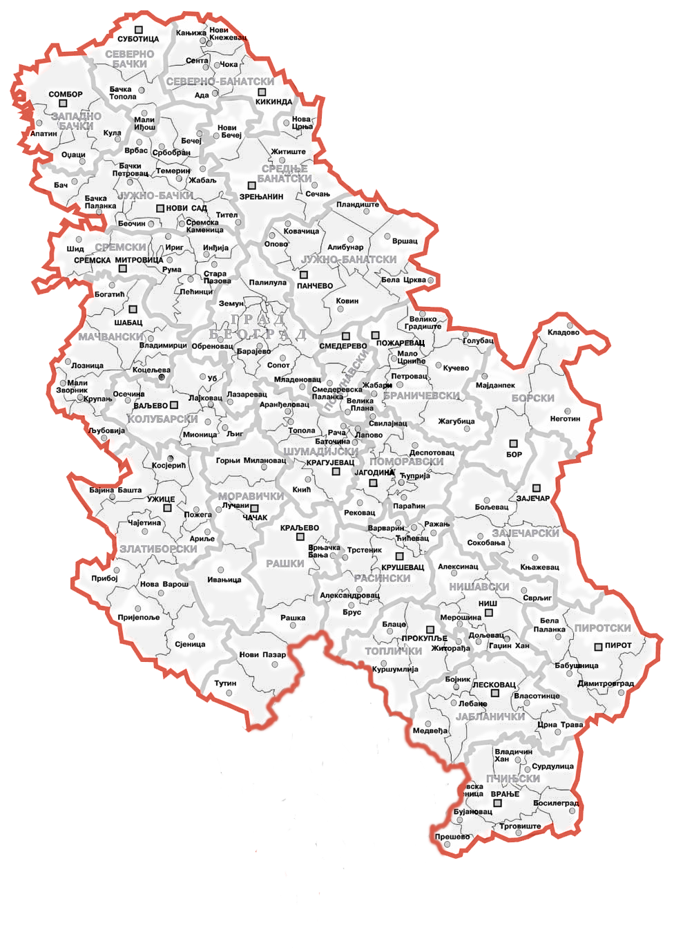
| 설명 | This map shows Serbian municipalities after Kosovo declared independence in 2008 | ||
| 날짜 | |||
| 출처 | Administrative map of Serbia on the Serbian Wikipedia | ||
| 저자 | Bože pravde added the towns, villages and names of municipalities | ||
| 저작권 (이 파일을 인용하기) |
|
||
| 다른 버전 |
|
.png)
.PNG?uselang=ko)
파일 역사
날짜/시간 링크를 클릭하면 해당 시간의 파일을 볼 수 있습니다.
.PNG&dir=prev)
.PNG&offset=20131016071409)
.PNG&offset=&limit=20)
.PNG&offset=&limit=50)
.PNG&offset=&limit=100)
.PNG&offset=&limit=250)
.PNG&offset=&limit=500)
| 날짜/시간 | 섬네일 | 크기 | 사용자 | 설명 | |
|---|---|---|---|---|---|
| 현재 | 2020년 1월 26일 (일) 18:29 | | 976 × 1,372 (946 KB) | Denniss | Reverted to version as of 11:53, 15 January 2014 (UTC) - nationalist POV |
| 2020년 1월 26일 (일) 17:11 |  | 976 × 1,372 (1.04 MB) | Sadko | Reverted to version as of 10:55, 15 January 2014 (UTC) per NPOV and the fact that this is a disputed aread and NOT a UN member state. Views of editor's country of origin are not relevant in this matter, and we should go per NPOV. | |
| 2014년 1월 15일 (수) 20:53 |  | 976 × 1,372 (946 KB) | Denniss | Reverted to version as of 13:17, 3 December 2013 | |
| 2014년 1월 15일 (수) 19:55 |  | 976 × 1,372 (1.04 MB) | Milicevic01 | Reverted to version as of 12:12, 3 December 2013 | |
| 2013년 12월 3일 (화) 22:17 |  | 976 × 1,372 (946 KB) | Denniss | Reverted to version as of 15:38, 2 December 2013 | |
| 2013년 12월 3일 (화) 21:12 |  | 976 × 1,372 (1.04 MB) | Nikola Smolenski | Reverted to version as of 15:06, 2 December 2013 | |
| 2013년 12월 3일 (화) 00:38 |  | 976 × 1,372 (946 KB) | Bobrayner | Back to the consensus version. Welcome to 2013! | |
| 2013년 12월 3일 (화) 00:06 |  | 976 × 1,372 (1.04 MB) | Nikola Smolenski | Reverted to version as of 00:28, 16 October 2013: By laws of Serbia, these are still municipalities of Serbia | |
| 2013년 11월 30일 (토) 17:20 |  | 976 × 1,372 (946 KB) | Denniss | Reverted to version as of 07:14, 16 October 2013 | |
| 2013년 10월 16일 (수) 16:14 |  | 976 × 1,372 (946 KB) | No More Cats | updating to reflect 2008 borders, per File talk:Continental-Europe-map.png |
이 파일을 사용하는 문서
이 파일을 사용하는 문서가 없습니다.
.PNG)