
파일:Map of Israel, neighbours and occupied territories.svg

원본 파일 (SVG 파일, 실제 크기 559 × 721 픽셀, 파일 크기: 650 KB)
파일 설명
| 설명 |
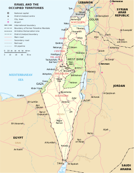
English: Map of the Middle East showing Israel, Egypt, Saudi Arabia, Jordan, Syria and Lebanon including Gaza, Golan Heights and West Bank.
العربية: خريطة دولة إسرائيل والأراضي الفلسطينية التي تشمل الضفة الغربية وقطاع غزة والجولان السوري المحتل. |
| 날짜 | |
| 출처 | SVG extracted and edited from PDF |
| 저자 | un.org |
| 다른 버전 | македонски |
| SVG 발전 |
라이선스
| This image is a map derived from a United Nations map.
Unless stated otherwise, UN maps are to be considered in the public domain. This applies worldwide. UN maps are, in principle, open source material and you can use them in your work or for making your own map. UN requests however that you delete the UN name, logo and reference number upon any modification to the map. Content of your map will be your responsibility. You can state in your publication, if you wish, something like: based on UN map … (map name, map number, revision number and date). See: Geospatial Information Section. And: Geospatial, location data for a better world. |
 |
| 나는 이 작품의 저작권자로서, 이 작품을 퍼블릭 도메인으로 모두에게 공개합니다. 이 공개 선언은 전 세계적으로 유효합니다. 만약 저작권의 포기가 법률적으로 가능하지 않은 경우, 나는 이 작품을 법적으로 허용되는 한도 내에서 누구나 자유롭게 어떤 목적으로도 제한없이 사용할 수 있도록 허용합니다. |
파일 역사
날짜/시간 링크를 클릭하면 해당 시간의 파일을 볼 수 있습니다.
| 날짜/시간 | 섬네일 | 크기 | 사용자 | 설명 | |
|---|---|---|---|---|---|
| 현재 | 2023년 10월 8일 (일) 01:07 | | 559 × 721 (650 KB) | LametinoWiki | File uploaded using svgtranslate tool (https://svgtranslate.toolforge.org/). Added translation for it. |
| 2023년 10월 8일 (일) 01:07 |  | 559 × 721 (650 KB) | LametinoWiki | File uploaded using svgtranslate tool (https://svgtranslate.toolforge.org/). Added translation for it. | |
| 2022년 12월 27일 (화) 10:49 |  | 559 × 721 (596 KB) | Wikijahnn | File uploaded using svgtranslate tool (https://svgtranslate.toolforge.org/). Added translation for ca. | |
| 2022년 12월 27일 (화) 10:46 |  | 559 × 721 (596 KB) | Wikijahnn | File uploaded using svgtranslate tool (https://svgtranslate.toolforge.org/). Added translation for ca. | |
| 2018년 5월 6일 (일) 02:09 |  | 559 × 721 (540 KB) | FrankieF | Reverted to version as of 23:22, 5 March 2018 (UTC). Replaces a bad and blurred map without distance meter to a crisp and clear map. | |
| 2018년 3월 11일 (일) 03:47 |  | 559 × 721 (285 KB) | Eric's son | The last version is outdated and factually incorrect. Reverted to version as of 21:50, 26 February 2018 (UTC) | |
| 2018년 3월 6일 (화) 08:22 |  | 559 × 721 (540 KB) | Nableezy | Reverted to version as of 16:20, 12 December 2011 (UTC) make a different map, dont replace every other with this one | |
| 2018년 2월 27일 (화) 06:50 |  | 559 × 721 (285 KB) | Eric's son | small graphic fixes | |
| 2018년 2월 20일 (화) 07:24 |  | 559 × 721 (259 KB) | Eric's son | Adding relevant updates (evacuated UN zones), clear colored borders explained in legend. | |
| 2011년 12월 13일 (화) 01:20 |  | 559 × 721 (540 KB) | Ch1902 | =={{int:filedesc}}== {{Information |Description={{en|1=Map of the Middle East showing Israel, Egypt, Saudi Arabia, Jordan, Syria and Lebanon including Gaza, Golan Heights and West Bank.}} |Source=SVG extracted and edited from [http://www.un.org/Depts/Car |
이 파일을 사용하는 문서
다음 문서 1개가 이 파일을 사용하고 있습니다:
이 파일을 사용하고 있는 모든 위키의 문서 목록
다음 위키에서 이 파일을 사용하고 있습니다:
- ary.wikipedia.org에서 이 파일을 사용하고 있는 문서 목록
- azb.wikipedia.org에서 이 파일을 사용하고 있는 문서 목록
- bxr.wikipedia.org에서 이 파일을 사용하고 있는 문서 목록
- ca.wikipedia.org에서 이 파일을 사용하고 있는 문서 목록
- da.wikipedia.org에서 이 파일을 사용하고 있는 문서 목록
- en.wikipedia.org에서 이 파일을 사용하고 있는 문서 목록
- ga.wikipedia.org에서 이 파일을 사용하고 있는 문서 목록
- gl.wikipedia.org에서 이 파일을 사용하고 있는 문서 목록
- hy.wikipedia.org에서 이 파일을 사용하고 있는 문서 목록
- it.wikipedia.org에서 이 파일을 사용하고 있는 문서 목록
- kn.wikipedia.org에서 이 파일을 사용하고 있는 문서 목록
- nl.wikipedia.org에서 이 파일을 사용하고 있는 문서 목록
- pap.wikipedia.org에서 이 파일을 사용하고 있는 문서 목록
- pnb.wikipedia.org에서 이 파일을 사용하고 있는 문서 목록
- ru.wikipedia.org에서 이 파일을 사용하고 있는 문서 목록
- sr.wikipedia.org에서 이 파일을 사용하고 있는 문서 목록
- sv.wikipedia.org에서 이 파일을 사용하고 있는 문서 목록
- www.wikidata.org에서 이 파일을 사용하고 있는 문서 목록