
파일:Mali Gao.png
최대 해상도입니다.
Mali_Gao.png (449 × 443 픽셀, 파일 크기: 5 KB, MIME 종류: image/png)
파일 설명
| 설명 |
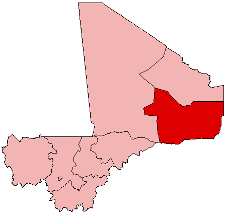
English: Map of Mali showing Gao Region; created with the GIMP. Made by User:Acntx. |
| 날짜 | 2005년 7월 31일 (원본 올리기 일시) |
| 출처 | 자작 |
| 저자 | 영어 위키백과의 Acntx |
라이선스
| 이 파일은 크리에이티브 커먼즈 저작자표시-동일조건변경허락 3.0 Unported 라이선스로 배포됩니다. 면책 조항이 적용됩니다. | ||
| 저작자표시: 영어 위키백과의 Acntx | ||
| ||
| 이 라이선스 틀은 GFDL 라이선스 변경의 일부로 이 파일에 추가되었습니다. |

|
GNU 자유 문서 사용 허가서 1.2판 또는 자유 소프트웨어 재단에서 발행한 이후 판의 규정에 따라 본 문서를 복제하거나 개작 및 배포할 수 있습니다. 본 문서에는 변경 불가 부분이 없으며, 앞 표지 구절과 뒷 표지 구절도 없습니다. 본 사용 허가서의 전체 내용은 GNU 자유 문서 사용 허가서 부분에 포함되어 있습니다. 면책 조항이 적용됩니다. |
기존 올리기 기록
The original description page was here. All following user names refer to en.wikipedia.
- 2005-07-31 21:18 Acntx 449×443 (5341 bytes)
파일 역사
날짜/시간 링크를 클릭하면 해당 시간의 파일을 볼 수 있습니다.
| 날짜/시간 | 섬네일 | 크기 | 사용자 | 설명 | |
|---|---|---|---|---|---|
| 현재 | 2012년 7월 13일 (금) 04:56 | | 449 × 443 (5 KB) | MGA73bot2 | {{BotMoveToCommons|en.wikipedia|year={{subst:CURRENTYEAR}}|month={{subst:CURRENTMONTHNAME}}|day={{subst:CURRENTDAY}}}} == {{int:filedesc}} == {{Information |description={{en|1=Map of Mali showing Gao Region; created with the GIMP. Made by [[:en:User:A... |
이 파일을 사용하는 문서
이 파일을 사용하는 문서가 없습니다.
이 파일을 사용하고 있는 모든 위키의 문서 목록
다음 위키에서 이 파일을 사용하고 있습니다:
- en.wikipedia.org에서 이 파일을 사용하고 있는 문서 목록
- Gao
- Gao Region
- La Dune Rose
- Bakal, Gao Region
- Bamba, Gao Region
- Bourem
- Labbezenga
- Gao International Airport
- Ansongo
- Wikipedia:WikiProject Mali/Regional commune templates
- Template:Communes of the Gao Region
- Ansongo Cercle
- Bourem Cercle
- Gao Cercle
- Koïma
- Template:Gao-geo-stub
- Bara, Gao Region
- Ouattagouna
- Talataye
- Tessit
- Tin-Hama
- Temera, Gao Region
- Tarkint
- Taboye
- Bourra
- Anchawadi
- Gabero
- Gounzoureye
- N'Tillit
- Sony Aliber
- Tilemsi, Gao
- Djebock
- Haoussa Foulane
- Wabaria
- Forgo Sourhai
- Tine Aouker
- Tassiga
- Category:Populated places in Gao Region
- User:Cobblet/Watched pages
- simple.wikipedia.org에서 이 파일을 사용하고 있는 문서 목록
- uz.wikipedia.org에서 이 파일을 사용하고 있는 문서 목록
- www.wikidata.org에서 이 파일을 사용하고 있는 문서 목록
- zh.wikipedia.org에서 이 파일을 사용하고 있는 문서 목록
이 파일의 더 많은 사용 내역을 봅니다.