
파일:Maas memel etsch belt.svg

SVG 파일의 PNG 형식의 미리보기 크기: 650 × 600 픽셀. 다른 해상도: 260 × 240 픽셀 | 520 × 480 픽셀 | 832 × 768 픽셀 | 1,109 × 1,024 픽셀 | 2,219 × 2,048 픽셀 | 1,300 × 1,200 픽셀
원본 파일 (SVG 파일, 실제 크기 1,300 × 1,200 픽셀, 파일 크기: 608 KB)
파일 설명
Description - Beschreibung
| 설명 |
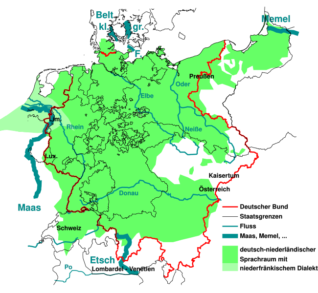
English: The German national anthem Deutschlandlied was written in 1841, giving four water bodies as borders of the German language Sprachraum of the time "Von der Maas bis an die Memel, von der Etsch bis an den Belt". This maps outlines them, and the border of the German Confederation of the time.
Deutsch: "Von der Maas bis an die Memel, von der Etsch bis an den Belt", die 4 "Grenzen" aus dem Deutschlandlied im geographisch-historischen Kontext von 1841:
Die Grenzen wurden der Karte auf der Seite Deutscher Bund entnommen und auf den Zustand 1841 vereinfacht. Die Sprachverteilung wurde stark vereinfacht aus einer Karte der Seite Deutsche Sprache entnommen und gibt den Zustand von 1910 wieder, der sich aber vermutlich nicht so stark von 1841 unterscheidet. Sie soll nur grobe Zusammenhänge zwischen damaliger Sprachverteilung zu den damaligen Grenzen aufzeigen. |
| 날짜 | |
| 출처 | like File:Map-DB-Frankfurt.svg from http://www.ieg-maps.uni-mainz.de, and: File:Deutscher Bund.png, File:Historisches deutsches Sprachgebiet.PNG, File:Continental West Germanic languages.png |
| 저자 | Mueck |
| 다른 버전 | |
| SVG 발전 |


.svg)
라이선스
나는 아래 작품의 저작권자로서, 이 저작물을 다음과 같은 라이선스로 배포합니다:

|
GNU 자유 문서 사용 허가서 1.2판 또는 자유 소프트웨어 재단에서 발행한 이후 판의 규정에 따라 본 문서를 복제하거나 개작 및 배포할 수 있습니다. 본 문서에는 변경 불가 부분이 없으며, 앞 표지 구절과 뒷 표지 구절도 없습니다. 본 사용 허가서의 전체 내용은 GNU 자유 문서 사용 허가서 부분에 포함되어 있습니다. |
이 파일은 크리에이티브 커먼즈 저작자표시 3.0 Unported 라이선스로 배포됩니다.
- 이용자는 다음의 권리를 갖습니다:
- 공유 및 이용 – 저작물의 복제, 배포, 전시, 공연 및 공중송신
- 재창작 – 저작물의 개작, 수정, 2차적저작물 창작
- 다음과 같은 조건을 따라야 합니다:
- 저작자표시 – 적절한 저작자 표시를 제공하고, 라이센스에 대한 링크를 제공하고, 변경사항이 있는지를 표시해야 합니다. 당신은 합리적인 방식으로 표시할 수 있지만, 어떤 방식으로든 사용권 허가자가 당신 또는 당신의 사용을 지지하는 방식으로 표시할 수 없습니다.
이 라이선스 중에서 목적에 맞는 것을 선택하여 사용할 수 있습니다.
파일 역사
날짜/시간 링크를 클릭하면 해당 시간의 파일을 볼 수 있습니다.
| 날짜/시간 | 섬네일 | 크기 | 사용자 | 설명 | |
|---|---|---|---|---|---|
| 현재 | 2023년 8월 11일 (금) 11:33 | | 1,300 × 1,200 (608 KB) | Amlz | Reverted to version as of 13:07, 30 May 2017 (UTC) to correct weird vector artifacts |
| 2017년 7월 22일 (토) 10:00 |  | 1,301 × 1,201 (652 KB) | AKAKIOS | Removed the Dutch speaking area and left only the Dutch/Low Frankish dialects in modern Germany. To add the Netherlands and Flanders to this map is inaccurate, both in its contemporary and historical context. | |
| 2017년 5월 30일 (화) 22:07 |  | 1,300 × 1,200 (608 KB) | Mueck | Reverted to version as of 19:16, 27 January 2011 (UTC) Indeed: Correctomundo~commonswiki produced bad quality, autotraced (or some other bad technic ...) and content: the "historic continuum" is just the interesting thing in this map ... | |
| 2014년 8월 12일 (화) 09:03 |  | 1,301 × 1,201 (652 KB) | Correctomundo~commonswiki | Fixed. | |
| 2014년 8월 12일 (화) 08:55 |  | 1,300 × 1,200 (608 KB) | Correctomundo~commonswiki | Same problem. | |
| 2014년 8월 12일 (화) 08:55 |  | 1,300 × 1,200 (608 KB) | Correctomundo~commonswiki | Same problem. | |
| 2014년 8월 12일 (화) 08:54 |  | 1,625 × 1,500 (241 KB) | Correctomundo~commonswiki | Color correction. | |
| 2014년 8월 12일 (화) 08:53 |  | 1,300 × 1,200 (608 KB) | Correctomundo~commonswiki | something went wrong with the colours | |
| 2014년 8월 12일 (화) 08:53 |  | 1,625 × 1,500 (57 KB) | Correctomundo~commonswiki | Removed Dutch and Standard Dutch influenced dialects. These are not German dialects, even though there historically was a continuum. | |
| 2011년 1월 28일 (금) 04:16 |  | 1,300 × 1,200 (608 KB) | NordNordWest | c |
이 파일을 사용하는 문서
다음 문서 1개가 이 파일을 사용하고 있습니다:
이 파일을 사용하고 있는 모든 위키의 문서 목록
다음 위키에서 이 파일을 사용하고 있습니다:
- az.wikipedia.org에서 이 파일을 사용하고 있는 문서 목록
- cs.wikipedia.org에서 이 파일을 사용하고 있는 문서 목록
- de.wikipedia.org에서 이 파일을 사용하고 있는 문서 목록
- en.wikipedia.org에서 이 파일을 사용하고 있는 문서 목록
- fi.wikipedia.org에서 이 파일을 사용하고 있는 문서 목록
- fr.wikipedia.org에서 이 파일을 사용하고 있는 문서 목록
- ka.wikipedia.org에서 이 파일을 사용하고 있는 문서 목록
- sr.wikipedia.org에서 이 파일을 사용하고 있는 문서 목록
- zh-yue.wikipedia.org에서 이 파일을 사용하고 있는 문서 목록
- zh.wikipedia.org에서 이 파일을 사용하고 있는 문서 목록