
파일:MBTA Commuter Rail and funding district map.svg

SVG 파일의 PNG 형식의 미리보기 크기: 800 × 489 픽셀. 다른 해상도: 320 × 196 픽셀 | 640 × 392 픽셀 | 1,024 × 626 픽셀 | 1,280 × 783 픽셀 | 2,560 × 1,566 픽셀 | 904 × 553 픽셀
원본 파일 (SVG 파일, 실제 크기 904 × 553 픽셀, 파일 크기: 2.37 MB)
파일 설명
| 설명 |
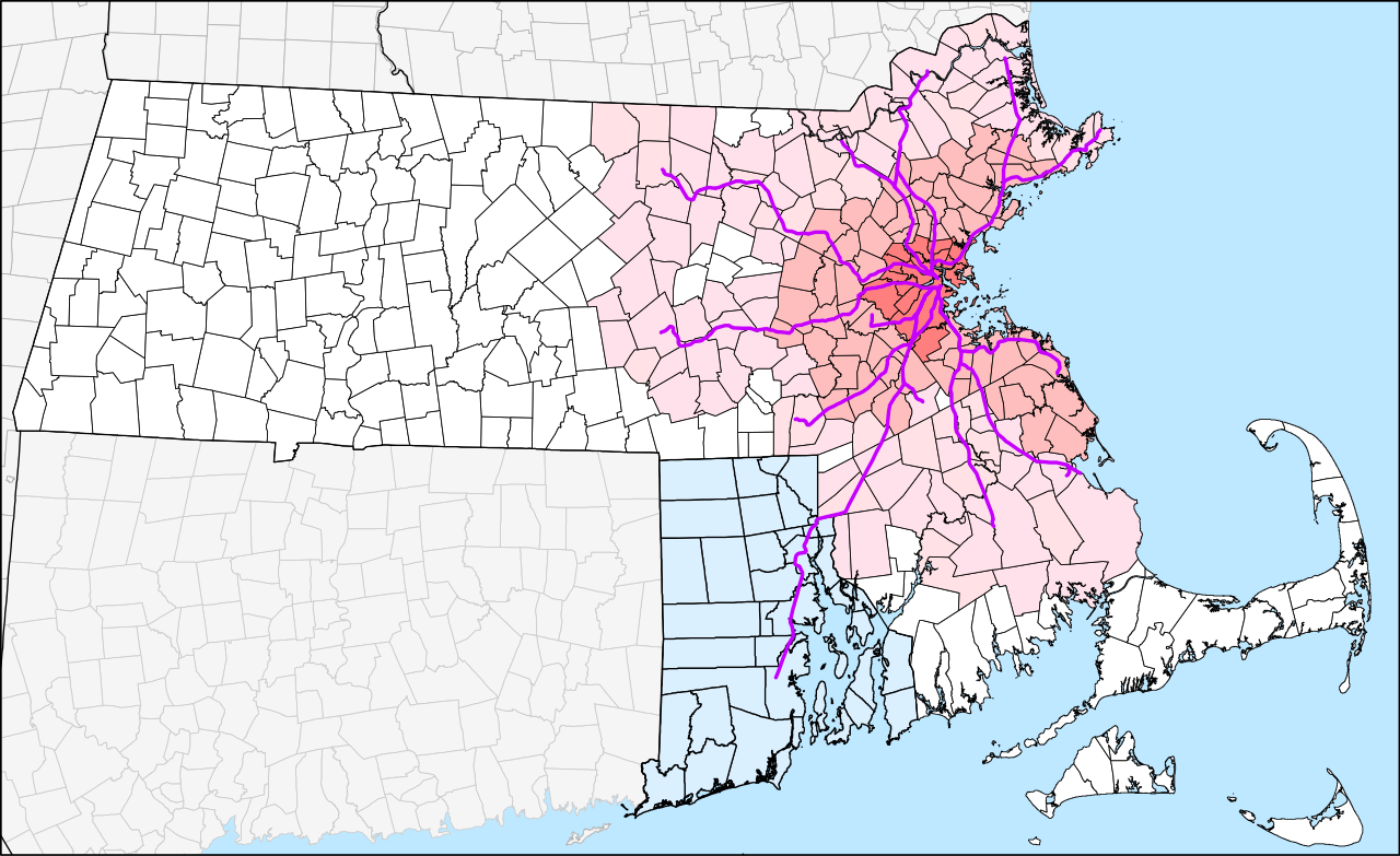
English: Geographic map of the MBTA Commuter Rail system and the MBTA funding district. The original 14-town MTA district is shown in darkest pink, the 78-town MBTA district established in 1964 in medium pink, and the 175-town "forward funding" district established in 1999 as light pink. White areas are not part of the MBTA district but still pay state sales taxes which are partially used to fund the MBTA.
Rhode Island, which is not part of the district but pays for service to 3 stations under the 1988 Pilgrim Partnership, is shown in light blue. |
| 날짜 | The map was originally uploaded on 29 March 2006. The latest version is accurate to the 23 April 2012 extension to Wickford Junction. |
| 출처 |
자작 by User:Pi.1415926535 |
| 저자 |
User:Pi.1415926535 (version 2) SPUI (version 1) |
| 다른 버전 |
이 파일은 다음으로 파생됨: |
| SVG 발전 |
라이선스
| 나는 이 작품의 저작권자로서, 이 작품을 퍼블릭 도메인으로 모두에게 공개합니다. 이 공개 선언은 전 세계적으로 유효합니다. 만약 저작권의 포기가 법률적으로 가능하지 않은 경우, 나는 이 작품을 법적으로 허용되는 한도 내에서 누구나 자유롭게 어떤 목적으로도 제한없이 사용할 수 있도록 허용합니다. |
파일 역사
날짜/시간 링크를 클릭하면 해당 시간의 파일을 볼 수 있습니다.
| 날짜/시간 | 섬네일 | 크기 | 사용자 | 설명 | |
|---|---|---|---|---|---|
| 현재 | 2014년 2월 21일 (금) 05:46 | | 904 × 553 (2.37 MB) | Pi.1415926535 | Slight zoom in |
| 2014년 2월 21일 (금) 05:30 |  | 961 × 556 (2.51 MB) | Pi.1415926535 | Version 2.0.0: New version from all-new datasets. Town outlines from MassGIS, state outlines from USGS, and rail lines from article's KML file. Adjacent states have been added; some minor errors remain. | |
| 2012년 8월 3일 (금) 14:04 |  | 8,248 × 5,248 (4.97 MB) | Pi.1415926535 | Grouping etc. No visual changes to map. | |
| 2012년 8월 3일 (금) 13:53 |  | 8,248 × 5,248 (4.97 MB) | Pi.1415926535 | Adding Rhode Island map from File:Providence Metro Area.svg | |
| 2012년 4월 23일 (월) 12:08 |  | 8,248 × 5,248 (4.92 MB) | Pi.1415926535 | Wickford Junction opens tomorrow! | |
| 2011년 7월 13일 (수) 13:21 |  | 8,248 × 5,248 (4.92 MB) | Pi.1415926535 | Updated with under-construction Wachusett and Wickford Junction extensions. Grouped segments into lines for easier modification. (See talk page). | |
| 2011년 5월 15일 (일) 08:39 |  | 8,248 × 5,248 (4.9 MB) | Pi.1415926535 | T.F. Green Extension and Greenbush Line are now open since the creation of the map. Also added Wildcat (Wilmington) Branch between Lowell and Haverhill lines; it is used for some rush-hour trains. A few bits were ungrouped for ease of modification. | |
| 2006년 3월 29일 (수) 19:56 |  | 8,248 × 5,248 (4.84 MB) | SPUI~commonswiki | {{spuimap}} MBTA district. Old MTA district darkest, then original MBTA district, then 1999 expansion. Commuter Rail lines in purple, planned lines thinner and dashed. Data source: [http://www.mass.gov/mgis/download.htm Office of Geographic and Environme |
이 파일을 사용하는 문서
다음 문서 1개가 이 파일을 사용하고 있습니다:
이 파일을 사용하고 있는 모든 위키의 문서 목록
다음 위키에서 이 파일을 사용하고 있습니다:
- de.wikipedia.org에서 이 파일을 사용하고 있는 문서 목록
- en.wikipedia.org에서 이 파일을 사용하고 있는 문서 목록
- id.wikipedia.org에서 이 파일을 사용하고 있는 문서 목록
- simple.wikipedia.org에서 이 파일을 사용하고 있는 문서 목록
- sr.wikipedia.org에서 이 파일을 사용하고 있는 문서 목록
- www.wikidata.org에서 이 파일을 사용하고 있는 문서 목록
- zh-yue.wikipedia.org에서 이 파일을 사용하고 있는 문서 목록
- zh.wikipedia.org에서 이 파일을 사용하고 있는 문서 목록