
파일:IrishSeaReliefMap.jpg
미리 보기 크기: 415 × 600 픽셀 다른 해상도: 166 × 240 픽셀 | 332 × 480 픽셀 | 531 × 768 픽셀 | 1,043 × 1,507 픽셀
원본 파일 (1,043 × 1,507 픽셀, 파일 크기: 2.15 MB, MIME 종류: image/jpeg)
파일 설명
| 설명 |
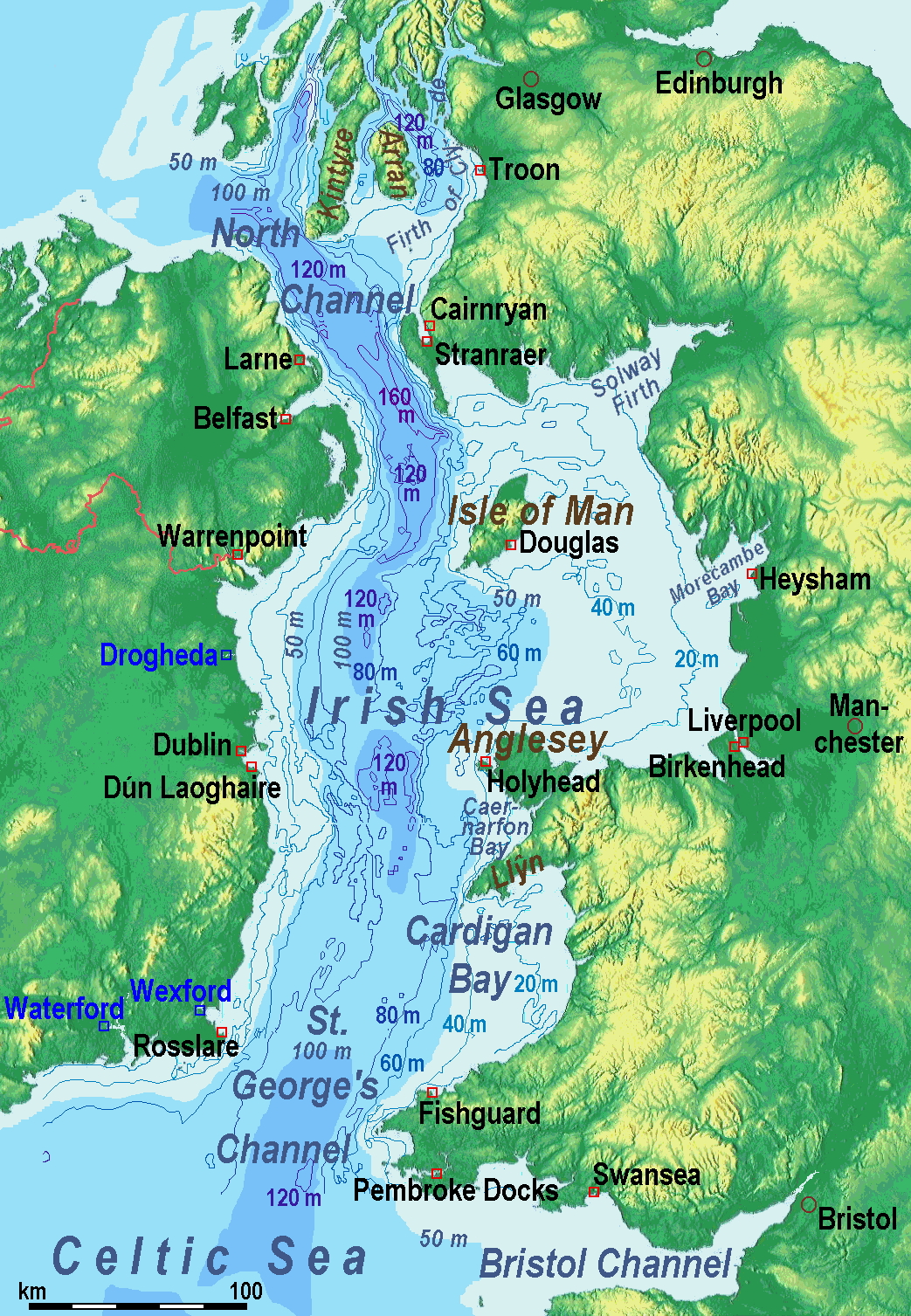
A map of the en:Irish Sea. Major ports shown with red marks. freight-only ports in blue. |
| 날짜 | old map 2005-08-03; new map 2014-05-11 |
| 출처 | old map: http://www.vindaloo.uklinux.net/jjg/code/tmutils.html-> new map: Maps for Free and 자작 |
| 저자 | old one Users SFC9394, Seabhcan on en.wikipedia, new one Ulamm (talk) 01:37, 11 May 2014 (UTC) |
| 저작권 (이 파일을 인용하기) |
old map: from http://www.vindaloo.uklinux.net/jjg/code/tmutils.html. Released to public domain by creator. |
| 다른 버전 |
History of the od map
Old map riginally from en.wikipedia; description page is (was) here
- 14:22, 20 March 2006 SFC9394 461×561 (85,860 bytes) (Corrected locations for Cairnryan & Stranraer)
- 10:56, 25 November 2005 Seabhcan 461×561 (73,292 bytes) (Removed the ports of Heysham and Fleetwood, to which en:User:Robdurbar took offence. )
- 16:23, 3 August 2005 Seabhcan 461×561 (95,162 bytes) (Added channel names)
- 15:50, 3 August 2005 Seabhcan 461×561 (93,219 bytes) (A map of the en:Irish Sea Major ports shown in red. freight only ports in blue. from [1]. Released to public domain by creator.)
Sources of information for the new map
- internal report Nr. 174 of the National Oceanography Centre (Liverpool)
- http://www.dcenr.gov.ie (Department of Communications, Energy and Natural Resources) -> IOSEA4Annex–Master–r02–Fiinal.pdf (Fourth Strategic Environmental Assessment for Oil and Gas ACtivity in Irelands Offshore Waters) -> figures 2.1 & 2.2a
라이선스
나는 아래 작품의 저작권자로서, 이 저작물을 다음과 같은 라이선스로 배포합니다:
이 파일은 크리에이티브 커먼즈 저작자표시-동일조건변경허락 3.0 Unported 라이선스로 배포됩니다.
- 이용자는 다음의 권리를 갖습니다:
- 공유 및 이용 – 저작물의 복제, 배포, 전시, 공연 및 공중송신
- 재창작 – 저작물의 개작, 수정, 2차적저작물 창작
- 다음과 같은 조건을 따라야 합니다:
- 저작자표시 – 적절한 저작자 표시를 제공하고, 라이센스에 대한 링크를 제공하고, 변경사항이 있는지를 표시해야 합니다. 당신은 합리적인 방식으로 표시할 수 있지만, 어떤 방식으로든 사용권 허가자가 당신 또는 당신의 사용을 지지하는 방식으로 표시할 수 없습니다.
- 동일조건변경허락 – 만약 당신이 이 저작물을 리믹스 또는 변형하거나 이 저작물을 기반으로 제작하는 경우, 당신은 당신의 기여물을 원저작물과 동일하거나 호환 가능한 라이선스에 따라 배포하여야 합니다.
(Uploaded using CommonsHelper or PushForCommons)
파일 역사
날짜/시간 링크를 클릭하면 해당 시간의 파일을 볼 수 있습니다.
| 날짜/시간 | 섬네일 | 크기 | 사용자 | 설명 | |
|---|---|---|---|---|---|
| 현재 | 2014년 5월 13일 (화) 20:42 | | 1,043 × 1,507 (2.15 MB) | Ulamm | optimized colour scale |
| 2014년 5월 12일 (월) 23:17 |  | 1,043 × 1,507 (1.87 MB) | Ulamm | more names, smaller letters | |
| 2014년 5월 11일 (일) 21:25 |  | 1,043 × 1,449 (1.73 MB) | Ulamm | depths and names of bays and inlets | |
| 2014년 5월 11일 (일) 19:56 |  | 1,043 × 1,449 (1.71 MB) | Ulamm | land colours lightened | |
| 2014년 5월 11일 (일) 11:22 |  | 1,043 × 1,449 (1.7 MB) | Ulamm | more ports | |
| 2014년 5월 11일 (일) 10:50 |  | 1,043 × 1,449 (1.69 MB) | Ulamm | completion outside the Irish Sea | |
| 2014년 5월 11일 (일) 10:39 |  | 1,043 × 1,449 (1.68 MB) | Ulamm | completely new map | |
| 2006년 11월 1일 (수) 18:01 |  | 461 × 561 (84 KB) | Korrigan | {{Information| |Description= A map of the en:Irish Sea Major ports shown in red. freight only ports in blue. |Source= |Date= |Author=Users SFC9394, Seabhcan on [http://en.wikipedia.org en.wikipedia] |Permiss |
이 파일을 사용하는 문서
이 파일을 사용하고 있는 모든 위키의 문서 목록
다음 위키에서 이 파일을 사용하고 있습니다:
- af.wikipedia.org에서 이 파일을 사용하고 있는 문서 목록
- an.wikipedia.org에서 이 파일을 사용하고 있는 문서 목록
- ast.wikipedia.org에서 이 파일을 사용하고 있는 문서 목록
- ba.wikipedia.org에서 이 파일을 사용하고 있는 문서 목록
- be.wikipedia.org에서 이 파일을 사용하고 있는 문서 목록
- bg.wikipedia.org에서 이 파일을 사용하고 있는 문서 목록
- bn.wikipedia.org에서 이 파일을 사용하고 있는 문서 목록
- br.wikipedia.org에서 이 파일을 사용하고 있는 문서 목록
- ca.wikipedia.org에서 이 파일을 사용하고 있는 문서 목록
- cs.wikipedia.org에서 이 파일을 사용하고 있는 문서 목록
- cv.wikipedia.org에서 이 파일을 사용하고 있는 문서 목록
- cy.wikipedia.org에서 이 파일을 사용하고 있는 문서 목록
- da.wikipedia.org에서 이 파일을 사용하고 있는 문서 목록
- el.wikipedia.org에서 이 파일을 사용하고 있는 문서 목록
- eo.wikipedia.org에서 이 파일을 사용하고 있는 문서 목록
- es.wikipedia.org에서 이 파일을 사용하고 있는 문서 목록
- eu.wikipedia.org에서 이 파일을 사용하고 있는 문서 목록
- fa.wikipedia.org에서 이 파일을 사용하고 있는 문서 목록
- fy.wikipedia.org에서 이 파일을 사용하고 있는 문서 목록
- gl.wikipedia.org에서 이 파일을 사용하고 있는 문서 목록
- gv.wikipedia.org에서 이 파일을 사용하고 있는 문서 목록
- he.wikipedia.org에서 이 파일을 사용하고 있는 문서 목록
- hu.wikipedia.org에서 이 파일을 사용하고 있는 문서 목록
- hu.wiktionary.org에서 이 파일을 사용하고 있는 문서 목록
- id.wikipedia.org에서 이 파일을 사용하고 있는 문서 목록
- is.wikipedia.org에서 이 파일을 사용하고 있는 문서 목록
- ka.wikipedia.org에서 이 파일을 사용하고 있는 문서 목록
- kk.wikipedia.org에서 이 파일을 사용하고 있는 문서 목록
- ku.wikipedia.org에서 이 파일을 사용하고 있는 문서 목록
- lmo.wikipedia.org에서 이 파일을 사용하고 있는 문서 목록
- lt.wikipedia.org에서 이 파일을 사용하고 있는 문서 목록
이 파일의 더 많은 사용 내역을 봅니다.