
파일:Indian states affected by July 2012 power cuts.svg

SVG 파일의 PNG 형식의 미리보기 크기: 530 × 599 픽셀. 다른 해상도: 212 × 240 픽셀 | 425 × 480 픽셀 | 680 × 768 픽셀 | 906 × 1,024 픽셀 | 1,812 × 2,048 픽셀 | 1,639 × 1,852 픽셀
원본 파일 (SVG 파일, 실제 크기 1,639 × 1,852 픽셀, 파일 크기: 302 KB)
파일 설명
| 설명 |
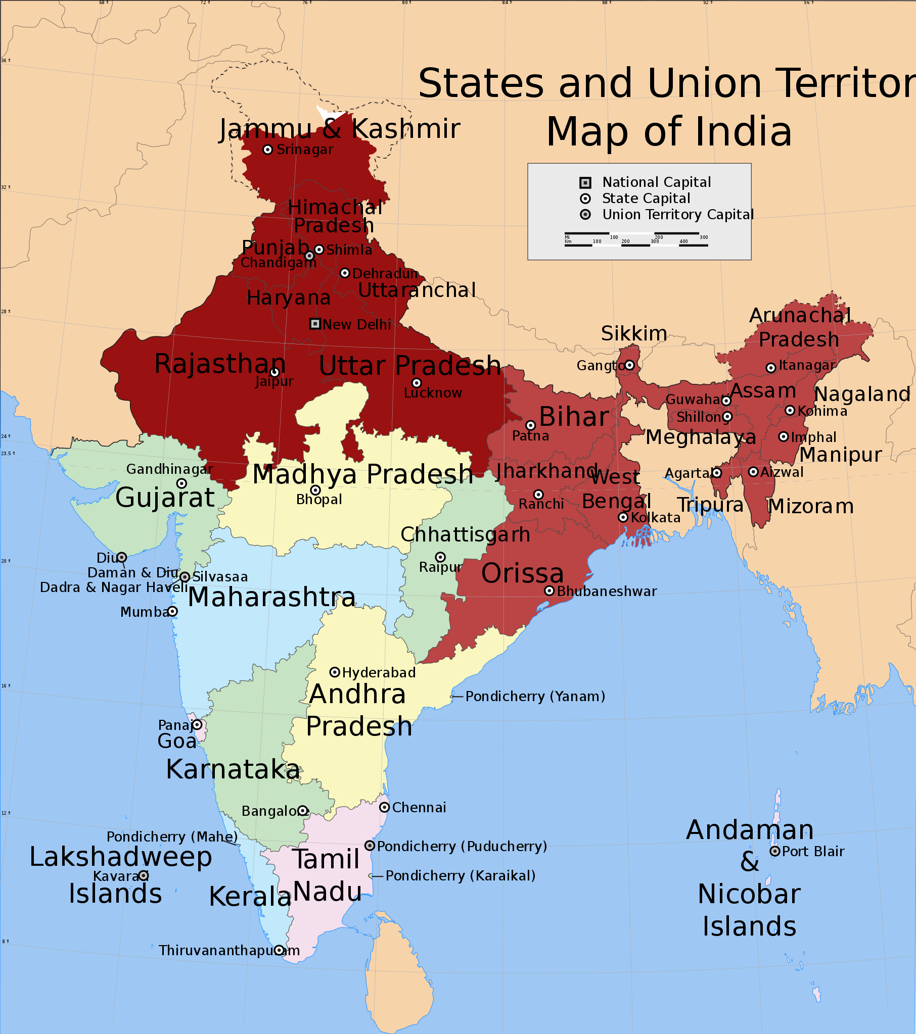
English: Shows in dark red the states listed at the time of creation: Jammu and Kashmir, Himachal Pradesh, Punjab, Haryana, Delhi, Rajasthan, Uttar Pradesh, Bihar, West Bengal, Orissa, Jharkhand, Sikkim, Assam, Meghalaya, Tripura, Nagaland, Manipur, Mizoram and Arunachal Pradesh.
Derived from India_states_and_union_territories_map.svg by changing the fill colour for those states. |
| 날짜 | Not known. Modified 2012년 7월 31일 |
| 출처 | File:India_states_and_union_territories_map.svg |
| 저자 | Whoever uploaded File:India_states_and_union_territories_map.svg to English Wikipedia |
| 저작권 (이 파일을 인용하기) |
http://en.wikipedia.org |
라이선스
이 파일은 크리에이티브 커먼즈 저작자표시-동일조건변경허락 1.0 일반 라이선스로 배포됩니다.
- 이용자는 다음의 권리를 갖습니다:
- 공유 및 이용 – 저작물의 복제, 배포, 전시, 공연 및 공중송신
- 재창작 – 저작물의 개작, 수정, 2차적저작물 창작
- 다음과 같은 조건을 따라야 합니다:
- 저작자표시 – 적절한 저작자 표시를 제공하고, 라이센스에 대한 링크를 제공하고, 변경사항이 있는지를 표시해야 합니다. 당신은 합리적인 방식으로 표시할 수 있지만, 어떤 방식으로든 사용권 허가자가 당신 또는 당신의 사용을 지지하는 방식으로 표시할 수 없습니다.
- 동일조건변경허락 – If you alter, transform, or build upon this work, you must distribute the resulting work under the same license as the original.
기존 올리기 기록
en.wikipedia에서 공용으로 옮겨왔습니다.
The original description page was here. All following user names refer to en.wikipedia.
- 2012-07-31 20:55 Maproom 1639×1852× (309753 bytes) Added Uttaranchal to affected area, removed Assam and states south and east of it.
- 2012-07-31 17:29 Maproom 1639×1852× (309753 bytes) Uploading a file from a free published source using [[Wikipedia:File_Upload_Wizard|File Upload Wizard]]
The original description page was here. All following user names refer to en.wikipedia.
- 2012-08-01 15:07 Maproom 1639×1852× (309753 bytes) altered the status of (Bihar, West Bengal, Jharkhand, Orissa, Chhattisgarh) to 2nd-day only.
- 2012-08-01 08:12 Maproom 1639×1852× (309753 bytes) re-added the north-eastern states, in a lighter colour
- 2012-08-01 08:09 Maproom 1639×1852× (309753 bytes) re-added the north-eastern states, in a lighter colour
- 2012-07-31 20:55 Maproom 1639×1852× (309753 bytes) Added Uttaranchal to affected area, removed Assam and states south and east of it.
- 2012-07-31 17:29 Maproom 1639×1852× (309753 bytes) Uploading a file from a free published source using [[Wikipedia:File_Upload_Wizard|File Upload Wizard]]
파일 역사
날짜/시간 링크를 클릭하면 해당 시간의 파일을 볼 수 있습니다.
| 날짜/시간 | 섬네일 | 크기 | 사용자 | 설명 | |
|---|---|---|---|---|---|
| 현재 | 2012년 8월 10일 (금) 00:17 | | 1,639 × 1,852 (302 KB) | Maproom | un-marked Chhattisgarh, in accordance with request at http://en.wikipedia.org/wiki/Wikipedia:WikiProject_Maps/Requested_and_orphan_maps |
| 2012년 8월 2일 (목) 02:34 |  | 1,639 × 1,852 (302 KB) | OgreBot | (BOT): Uploading old version of file from en.wikipedia; originally uploaded on 2012-08-01 15:07:18 by Maproom | |
| 2012년 8월 2일 (목) 02:33 |  | 1,639 × 1,852 (302 KB) | OgreBot | (BOT): Uploading old version of file from en.wikipedia; originally uploaded on 2012-08-01 08:09:17 by Maproom | |
| 2012년 8월 2일 (목) 02:33 |  | 1,639 × 1,852 (302 KB) | OgreBot | (BOT): Uploading old version of file from en.wikipedia; originally uploaded on 2012-07-31 17:29:42 by Maproom | |
| 2012년 8월 1일 (수) 13:36 |  | 1,639 × 1,852 (302 KB) | Makecat | {{Information |Description={{en|Shows in dark red the states listed at the time of creation: Jammu and Kashmir, Himachal Pradesh, Punjab, Haryana, Delhi, Rajasthan, Uttar Pradesh, Bihar, West Bengal, Orissa, Jharkhand, Sikkim, Assam, Meghalaya, Tripura... |
이 파일을 사용하는 문서
다음 문서 1개가 이 파일을 사용하고 있습니다:
이 파일을 사용하고 있는 모든 위키의 문서 목록
다음 위키에서 이 파일을 사용하고 있습니다:
- af.wikipedia.org에서 이 파일을 사용하고 있는 문서 목록
- ar.wikipedia.org에서 이 파일을 사용하고 있는 문서 목록
- en.wikipedia.org에서 이 파일을 사용하고 있는 문서 목록
- es.wikipedia.org에서 이 파일을 사용하고 있는 문서 목록
- fr.wikipedia.org에서 이 파일을 사용하고 있는 문서 목록
- he.wikipedia.org에서 이 파일을 사용하고 있는 문서 목록
- lv.wikipedia.org에서 이 파일을 사용하고 있는 문서 목록
- pt.wikipedia.org에서 이 파일을 사용하고 있는 문서 목록
- ru.wikipedia.org에서 이 파일을 사용하고 있는 문서 목록
- ta.wikipedia.org에서 이 파일을 사용하고 있는 문서 목록
- th.wikipedia.org에서 이 파일을 사용하고 있는 문서 목록
- vi.wikipedia.org에서 이 파일을 사용하고 있는 문서 목록
- zh.wikipedia.org에서 이 파일을 사용하고 있는 문서 목록