
파일:India in 1525 Joppen.jpg
미리 보기 크기: 411 × 599 픽셀 다른 해상도: 164 × 240 픽셀 | 329 × 480 픽셀 | 527 × 768 픽셀 | 1,251 × 1,824 픽셀
원본 파일 (1,251 × 1,824 픽셀, 파일 크기: 335 KB, MIME 종류: image/jpeg)
파일 설명
| 묘사 |
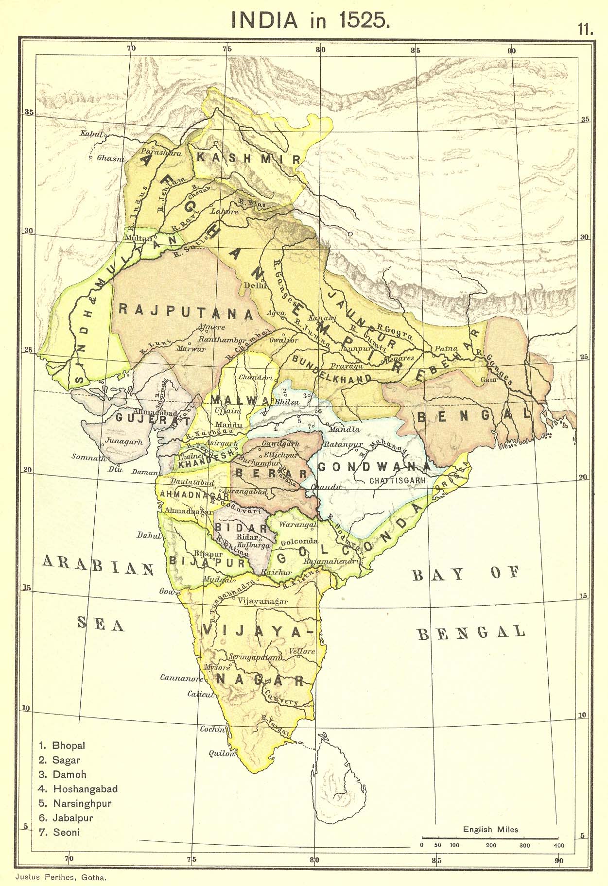
English: Map of India in 1525 |
|||||||||
| 날짜 | ||||||||||
| 출처 | "Historical Atlas of India," by Charles Joppen (London: Longmans, Green & Co., 1907) | |||||||||
| 창작자 |
Charles Joppen |
|||||||||
| 지리 정보 | ||||||||||
| 영역 상자 |
|
|||||||||
| 지리 참고 | ||||||||||
| 다른 버전 | 이 파일은 다음으로 파생됨: Mughals India 18th centur-cs.png | |||||||||
라이선스
This media file is in the public domain in the United States. This applies to U.S. works where the copyright has expired, often because its first publication occurred prior to January 1, 1929, and if not then due to lack of notice or renewal. See this page for further explanation.
|
 | |
 |
This image might not be in the public domain outside of the United States; this especially applies in the countries and areas that do not apply the rule of the shorter term for US works, such as Canada, Mainland China (not Hong Kong or Macao), Germany, Mexico, and Switzerland. The creator and year of publication are essential information and must be provided. See Wikipedia:Public domain and Wikipedia:Copyrights for more details.
|
파일 역사
날짜/시간 링크를 클릭하면 해당 시간의 파일을 볼 수 있습니다.
| 날짜/시간 | 섬네일 | 크기 | 사용자 | 설명 | |
|---|---|---|---|---|---|
| 현재 | 2010년 3월 7일 (일) 08:44 | | 1,251 × 1,824 (335 KB) | Abecedare | {{Information |Description={{en|1=Map of India in 1525}} |Source= "Historical Atlas of India," by Charles Joppen (London: Longmans, Green & Co., 1907) |Author=Charles Joppen |Date=1907 |Permission= |other_versions= }} |
이 파일을 사용하는 문서
이 파일을 사용하는 문서가 없습니다.
이 파일을 사용하고 있는 모든 위키의 문서 목록
다음 위키에서 이 파일을 사용하고 있습니다:
- ar.wikipedia.org에서 이 파일을 사용하고 있는 문서 목록
- azb.wikipedia.org에서 이 파일을 사용하고 있는 문서 목록
- az.wikipedia.org에서 이 파일을 사용하고 있는 문서 목록
- bn.wikipedia.org에서 이 파일을 사용하고 있는 문서 목록
- ca.wikipedia.org에서 이 파일을 사용하고 있는 문서 목록
- ce.wikipedia.org에서 이 파일을 사용하고 있는 문서 목록
- de.wikipedia.org에서 이 파일을 사용하고 있는 문서 목록
- en.wikipedia.org에서 이 파일을 사용하고 있는 문서 목록
- es.wikipedia.org에서 이 파일을 사용하고 있는 문서 목록
- fa.wikipedia.org에서 이 파일을 사용하고 있는 문서 목록
- fi.wikipedia.org에서 이 파일을 사용하고 있는 문서 목록
- fr.wikipedia.org에서 이 파일을 사용하고 있는 문서 목록
- gu.wikipedia.org에서 이 파일을 사용하고 있는 문서 목록
- hi.wikipedia.org에서 이 파일을 사용하고 있는 문서 목록
- hu.wikipedia.org에서 이 파일을 사용하고 있는 문서 목록
- hy.wikipedia.org에서 이 파일을 사용하고 있는 문서 목록
- it.wikipedia.org에서 이 파일을 사용하고 있는 문서 목록
- lt.wikipedia.org에서 이 파일을 사용하고 있는 문서 목록
- ml.wikipedia.org에서 이 파일을 사용하고 있는 문서 목록
- nl.wikipedia.org에서 이 파일을 사용하고 있는 문서 목록
- pa.wikipedia.org에서 이 파일을 사용하고 있는 문서 목록
- pnb.wikipedia.org에서 이 파일을 사용하고 있는 문서 목록
이 파일의 더 많은 사용 내역을 봅니다.