
파일:Hokushin-ron-Map.svg

SVG 파일의 PNG 형식의 미리보기 크기: 800 × 512 픽셀. 다른 해상도: 320 × 205 픽셀 | 640 × 409 픽셀 | 1,024 × 655 픽셀 | 1,280 × 819 픽셀 | 2,560 × 1,638 픽셀 | 1,038 × 664 픽셀
원본 파일 (SVG 파일, 실제 크기 1,038 × 664 픽셀, 파일 크기: 649 KB)
| 설명 |
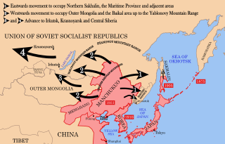
English: Strategic map of "Hoshukin-ron", the Japanese plans for a potential attack on the Soviet Union.
English: A map of the Imperial Powers of the Pacific, 1939-09-01. Dates shown indicate the approximate year that the various powers gain control of their possessions. Japanese control of territory in China was tenuous.
English: A Pacific-centered Mercator projection of the world with countries filled. Created in R using:
library(maps)
|
| 날짜 | (UTC) |
| 출처 | |
| 저자 |
| 이 그림은 수정된 그림으로, 원래 그림에서 디지털 변환이 이루어진 그림입니다. 수정 사항 : Redrawn as vector image. 원래의 그림 : Pacific Area - The Imperial Powers 1939 - Map.jpg:
|
이 파일은 크리에이티브 커먼즈 저작자표시-동일조건변경허락 3.0 Unported 라이선스로 배포됩니다.
- 이용자는 다음의 권리를 갖습니다:
- 공유 및 이용 – 저작물의 복제, 배포, 전시, 공연 및 공중송신
- 재창작 – 저작물의 개작, 수정, 2차적저작물 창작
- 다음과 같은 조건을 따라야 합니다:
- 저작자표시 – 적절한 저작자 표시를 제공하고, 라이센스에 대한 링크를 제공하고, 변경사항이 있는지를 표시해야 합니다. 당신은 합리적인 방식으로 표시할 수 있지만, 어떤 방식으로든 사용권 허가자가 당신 또는 당신의 사용을 지지하는 방식으로 표시할 수 없습니다.
- 동일조건변경허락 – 만약 당신이 이 저작물을 리믹스 또는 변형하거나 이 저작물을 기반으로 제작하는 경우, 당신은 당신의 기여물을 원저작물과 동일하거나 호환 가능한 라이선스에 따라 배포하여야 합니다.
기존 올리기 기록
This image is a derivative work of the following images:
- File:Hokushin-ron-Map.png licensed with Cc-by-sa-3.0, GFDL
- 2010-08-26T14:40:14Z Begoon 1013x615 (185183 Bytes) remove headline/tweak type
- 2010-01-13T18:41:06Z 36ophiuchi 1013x615 (248571 Bytes) Fixed some minor errors.
- 2010-01-11T23:12:35Z 36ophiuchi 1013x615 (246326 Bytes) {{Information |Description={{en|1=Strategic map of "Hoshukin-ron", the Japanese plans for a potential attack on the Soviet Union.}} |Source=*[[:File:Pacific_Area_-_The_Imperial_Powers_1939_-_Map.svg|]] |Date=2010-01-11 23:11
- File:Pacific_Area_-_The_Imperial_Powers_1939_-_Map.svg licensed with Cc-by-sa-3.0, GFDL
- 2010-08-27T15:13:24Z Splittist 1039x814 (4653684 Bytes) There's no need to create a new file. The map description shows that this map deviates from the one from which it originated: many borders were modified: e.x. East Timor, Mengjiang. It also welcomes changes based on better in
- 2010-08-27T10:11:31Z Kintetsubuffalo 1039x814 (4658296 Bytes) then you are welcome to create your own file, rather than editwarring
- 2010-08-27T06:54:08Z Splittist 1039x814 (4653684 Bytes) Well that map (not the govt, a military academy; and by no means are maps on the area consistent in borders) is wrong. Sheng Shicai, who pledged allegiance to China, controlled Xinjiang in 1939. Marking Xinjiang as separate i
- 2010-08-27T03:36:43Z Kintetsubuffalo 1039x814 (4658296 Bytes) the US government map this is based on shows it as separate
- 2010-08-27T01:26:43Z Splittist 1039x814 (4653684 Bytes) No reason for Xinjiang to have separate borders from China
- 2009-05-31T02:33:19Z Kmusser 1039x814 (4658296 Bytes) add macau, fix marianas, hainan spelling
- 2008-10-30T15:20:49Z Valentim 1039x814 (4703043 Bytes) Reverted to version as of 05:16, 22 September 2008. The international name is "Sea of Japan".
- 2008-09-24T07:42:22Z 쿠도군 1039x814 (4704268 Bytes) Reverted to version as of 07:53, 11 September 2008
- 2008-09-22T05:16:58Z Chris 73 1039x814 (4703043 Bytes) Reverted to version as of 02:54, 21 August 2008
- 2008-09-11T07:53:32Z 쿠도군 1039x814 (4704268 Bytes) new version.
- 2008-08-21T02:54:43Z Emok 1039x814 (4703043 Bytes) {{Information |Description= |Source= |Date= |Author= |Permission= |other_versions= }}
- 2008-08-21T02:44:29Z Emok 1039x814 (4702923 Bytes) {{Information |Description= |Source= |Date= |Author= |Permission= |other_versions= }}
- 2008-08-08T01:16:33Z Emok 1039x814 (4678233 Bytes) {{Information |Description= |Source= |Date= |Author= |Permission= |other_versions= }}
- 2008-08-08T00:07:48Z Emok 1039x814 (4669659 Bytes) {{Information |Description= |Source= |Date= |Author= |Permission= |other_versions= }}
- 2008-08-07T05:03:23Z Emok 1039x814 (4669195 Bytes) {{Information |Description= |Source= |Date= |Author= |Permission= |other_versions= }}
- 2008-08-07T04:28:58Z Emok 1039x814 (4623405 Bytes) {{Information |Description= |Source= |Date= |Author= |Permission= |other_versions= }}
- 2008-08-07T04:02:57Z Emok 1039x814 (4602891 Bytes) {{Information |Description= |Source= |Date= |Author= |Permission= |other_versions= }}
- 2008-08-07T03:24:03Z Emok 1039x814 (4669511 Bytes) {{Information |Description= |Source= |Date= |Author= |Permission= |other_versions= }}
- 2008-08-04T16:59:39Z Emok 1039x814 (6442489 Bytes) {{Information |Description= |Source= |Date= |Author= |Permission= |other_versions= }}
- 2008-08-04T05:38:24Z Emok 1039x814 (6427678 Bytes) {{Information |Description= |Source= |Date= |Author= |Permission= |other_versions= }} [[Category:Imperialism]] [[Category:Oceania]]
- 2008-08-04T05:26:00Z Emok 104x82 (4765313 Bytes) {{Information |Description={{en|1=A map of the Imperial Powers of the Pacific, 1939-09-01. }} |Source=*[[:Image:World2Hires_filled_mercator.svg|]] |Date=2008-08-04 05:22 (UTC) |Author=*derivative work: ~~~ *[[:Image:World2Hir
- File:World2Hires_filled_mercator.svg licensed with Cc-by-sa-3.0, GFDL
- 2008-08-03T06:38:19Z Emok 220x171 (12002488 Bytes) {{Information |Description= |Source= |Date= |Author= |Permission= |other_versions= }} [[Category:Blank SVG maps of the world]]
- 2008-08-03T06:00:29Z Emok 520x519 (3064180 Bytes) {{Information |Description={{en|1=A Pacific-centered Mercator projection of the world with countries filled.}} |Source=Own work by uploader |Author=[[User:Emok|Emok]] |Date=2008-08-01 |Permission= |other_versions= }} {{Image
- File:Pacific_Area_-_The_Imperial_Powers_1939_-_Map.jpg licensed with PD-USGov-Military-Army
Uploaded with derivativeFX
파일 역사
날짜/시간 링크를 클릭하면 해당 시간의 파일을 볼 수 있습니다.
| 날짜/시간 | 섬네일 | 크기 | 사용자 | 설명 | |
|---|---|---|---|---|---|
| 현재 | 2012년 1월 16일 (월) 12:37 | | 1,038 × 664 (649 KB) | Quigley | Xinjiang wasn't separate from China |
| 2010년 8월 29일 (일) 14:40 |  | 1,038 × 664 (653 KB) | Begoon | emphasise relevant font weights | |
| 2010년 8월 28일 (토) 19:04 |  | 1,038 × 664 (628 KB) | Begoon | you'd think a mountain range would be big enough not to miss - fixed font for last one... | |
| 2010년 8월 28일 (토) 19:00 |  | 1,038 × 664 (626 KB) | Begoon | font weight for Mountain ranges/Pt Arthur | |
| 2010년 8월 28일 (토) 18:43 |  | 1,038 × 664 (619 KB) | Begoon | {{Information |Description={{en|1=Strategic map of "Hoshukin-ron", the Japanese plans for a potential attack on the Soviet Union.}} {{en|1=A map of the Imperial Powers of the Pacific, 1939-09-01. Dates shown indicate the approximate year that the various |
이 파일을 사용하는 문서
다음 문서 1개가 이 파일을 사용하고 있습니다:
이 파일을 사용하고 있는 모든 위키의 문서 목록
다음 위키에서 이 파일을 사용하고 있습니다:
- azb.wikipedia.org에서 이 파일을 사용하고 있는 문서 목록
- az.wikipedia.org에서 이 파일을 사용하고 있는 문서 목록
- bg.wikipedia.org에서 이 파일을 사용하고 있는 문서 목록
- en.wikipedia.org에서 이 파일을 사용하고 있는 문서 목록
- es.wikipedia.org에서 이 파일을 사용하고 있는 문서 목록
- fa.wikipedia.org에서 이 파일을 사용하고 있는 문서 목록
- fr.wikipedia.org에서 이 파일을 사용하고 있는 문서 목록
- he.wikipedia.org에서 이 파일을 사용하고 있는 문서 목록
- id.wikipedia.org에서 이 파일을 사용하고 있는 문서 목록
- it.wikipedia.org에서 이 파일을 사용하고 있는 문서 목록
- ja.wikipedia.org에서 이 파일을 사용하고 있는 문서 목록
- mn.wikipedia.org에서 이 파일을 사용하고 있는 문서 목록
- ms.wikipedia.org에서 이 파일을 사용하고 있는 문서 목록
- no.wikipedia.org에서 이 파일을 사용하고 있는 문서 목록
- pt.wikipedia.org에서 이 파일을 사용하고 있는 문서 목록
- ru.wikipedia.org에서 이 파일을 사용하고 있는 문서 목록
- uk.wikipedia.org에서 이 파일을 사용하고 있는 문서 목록
- www.wikidata.org에서 이 파일을 사용하고 있는 문서 목록
- zh.wikipedia.org에서 이 파일을 사용하고 있는 문서 목록